• Vintage High Res Pictures Discussion

  • Discussion relating to commuter rail, light rail, and subway operations of the MBTA.
Discussion relating to commuter rail, light rail, and subway operations of the MBTA.

Moderators: sery2831, CRail

  by dieciduej
 
BostonUrbEx wrote:One question: where is "Lotus Place"?
Is was the a carhouse next to Arborway, I believe it closed in 1985 or 86. Arborway was originally the bus garage.

JoeD
  by Leo Sullivan
 
The identity of the car with the load of ties makes a nice advanced grade quiz question.
Also, where did it come from.
(I know but, I cheated)
LS
  by Gerry6309
 
dieciduej wrote:
BostonUrbEx wrote:One question: where is "Lotus Place"?
Is was the a carhouse next to Arborway, I believe it closed in 1985 or 86. Arborway was originally the bus garage.

JoeD
Lotus Place is the original name of Brookley Road.

The original carouse name was Forest Hills.

It was changed to Arborway after the Transfer Station opened there in 1923, to avoid confusion with the elevated station.

The MTA referred to the Carhouse as Lotus Place to avoid confusion with the Bus Garage, though the official name remained Arborway.

Similar situations:

Park St. Carhouse and Dorchester Bus Garage

Salem St. Carhouse and Fellsway Garage

Charlestown Neck Carhouse and Charlestown Garage

The Carhouse and Garage at Allston were not open simultaneously, so both were known as Allston.
  by TrainManTy
 
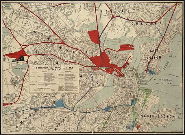
This isn't a picture, but an 1899 map of railroad terminal facilities in Boston. I found it extremely helpful for understanding where the various railroads ran in the city, and the history of some of the defunct routes I've stumbled across.

http://i.imgur.com/XQLYNTm.jpg
  by jaymac
 
Thanks!
  by MBTA3247
 
TrainManTy wrote:This isn't a picture, but an 1899 map of railroad terminal facilities in Boston. I found it extremely helpful for understanding where the various railroads ran in the city, and the history of some of the defunct routes I've stumbled across.

http://i.imgur.com/XQLYNTm.jpg
That map is just recent enough that it doesn't show many of the original passenger terminals. South Station had just opened, replacing the separate terminals of the Boston & Providence (located in the unusually large blocks just north of Back Bay), the Boston & Albany (located in the blue-shaded block next to South Station), the Old Colony and the New York & New England (located at the south and north ends of South Station's site).

On the north side of town, the first North Station had been built a few years earlier on the site of the (side by side) Boston & Lowell and Eastern RR stations, and site of the original B&M station by Haymarket Square had been redeveloped into a subway portal. The full consolidation of the north side terminal facilities into what we would recognize as Boston Engine Terminal and North Station was still a quarter century in the future, of course.
  by Palmer5RR
 
TrainManTy wrote:This isn't a picture, but an 1899 map of railroad terminal facilities in Boston. I found it extremely helpful for understanding where the various railroads ran in the city, and the history of some of the defunct routes I've stumbled across.
Very interesting. The map shows a rail line that goes all the way down Atlantic Ave from South Station to North Station and covers all the wharfs. I can't make out the name of the RR. It must have been ripped a long time ago. I started going to Boston regularly in the late 1970s and I do not remember see any traces of the track.
  by Cosmo
 
That was the Union Freight RR. It ended operations in the early '70's.
Frank Kyper's "The Railroad That Came Out A Night" cover it well.
  by The EGE
 
I found three different versions of that map; all were freely available from the BPL as public domain, and I've added them to Commons as well. They are labeled as 1893, 1899, and 1902, spanning the consolidation of railroads into South Station and North Union Station as well as major corporate moves.

1893: BPL, Commons
Image

1899: BPL, Commons
Image

1902: BPL, Commons
Image
  by BandA
 
Amazing. 1893 Shows Cove Street, proposed embankment, and the unbuilt fill area in East Cambridge! 21 years since the Great Boston Fire, Boston was a city on the move, and by move I mean by rail.
  by Adams_Umass_Boston
 
  by Adams_Umass_Boston
 
  by Adams_Umass_Boston
 
  • 1
  • 34
  • 35
  • 36
  • 37
  • 38
  • 43