Railroad Forums 

  • Railroads around Columbia, NJ

  • Pertaining to all railroading subjects, past and present, in New Jersey
Pertaining to all railroading subjects, past and present, in New Jersey

Moderator: David

 #189801  by Charlie7
 
Could anyone clarify the historic lines around Columbia? I know that the NYS&W row was used for Rt. 46. When was this done? Where did the Lehigh & New England branch off and where did it cross the Delaware? And where did the NYS&W connect?

 #189836  by Scrap The U34CH
 
This is a complicated one.
You can get a good idea of some of it here:
http://www.gingerb.com/index.html

The NYSnW came in past Columbia lake which you can see from 80W right before the truck stop. If you are on 46W right before the ramp to 80E you can look into the woods on the right of 46 and see a cut stone bridge over the end of the lake. This is the SnW. You can also see a rock cut further down into Columbia right in the area where the garbage trucks are parked. This is right across 46 from the DLnW old road bridge over the river.

The LNE came across in the area where 80 turns and runs right next to the river near the truck stop and the 80\46\94 interchanges. One of the bridge abutments is still on the Jersey side. The LNE then went off north of 94 for a mile or so before crossing 94 and heading to Hainesburgh Jct.

Do you have Google Earth?? If so, Let me know and I can give you the numbers to punch in to see this stuff.
 #189935  by pumpers
 
There were a a few lines...

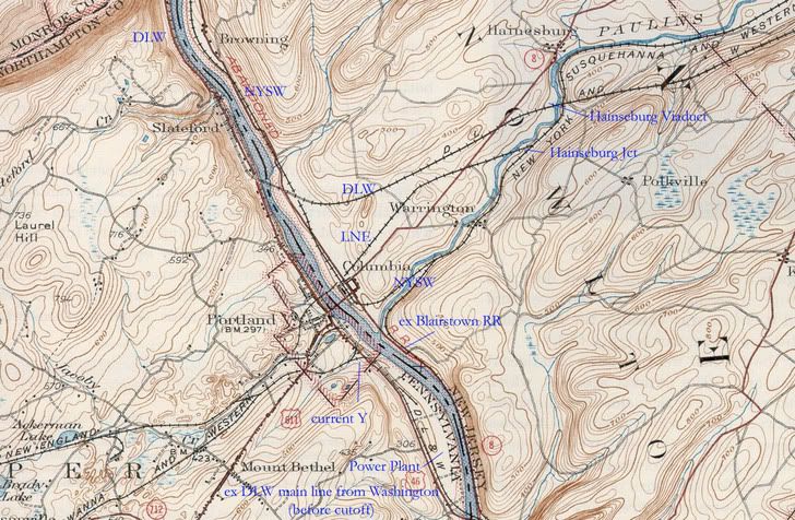
Coming east from the Blairstown area, mostly on the south/east side
of the Paulins Kill was the NYSW mainline. About a mile East of
COlumbia it forked. The north branch was the Lehigh and New England (LNE) mainline, which stayed on the north side of the Paulins Kill and went
right through COlubmia and over the Delaware to Portland.
Look at http://www.terraserver-usa.com/image.as ... ia%7cnj%7c and nearby --- the dotted purple line is the one we are talking about.
To the east of this junction the LNE used the NYSW mainline for some distance into NJ

East of the the junction I mentioned above, the NYSW mainline continued on the south of the Paulins Kill. CLoser to the Delaware River it forked again, with the mainline curving north along the Delaware, going back
across the Paulins KIill, and under the LNE in Columbia itself. THis
went north along the Delaware R and somewhere just north of the
Highway 80 bridget across the delaware R the NYSW crossed, going to Stroudsburg/Gravel
Place, where it connected with the WIlkes-Barre and Eastern, to get
to the Scranton/WIlkesbarre coal area. THis part along the river
north of COlumbia was mostly wiped out by 80, I think, but I don't
know details like the earlier poster.

The south fork of the second fork went south along the Delaware to a
place called "Delaware, about 1/2 way between COlumbia dn Mununka
CHunk. It ened there. I don't see the place on the terraserver map I listed above, it must have been just north of Ramseyburg on the map.
Part of this section is what is now covered by 46, I think (especially
north of the DLW bridge south of columbia up to the Paulins Kill).

Related to all this, at Manunka CHunk, the old DLW main came in to
the riverside coming north through tunnels. It then ran north, past the
town of Delaware, and then over the Delaware R on the bridge I just mentioned. The Portland PA power plant is right by this bridge now, I think trains
on the PA side sometimes back onto the bridge when switching, but
nothing in NJ is used (or even left!)
ALso, the Penn RR Bel-Del branch came north
along the river from the south, and ended at Manunka CHunk when
they connected with the DLW (maybe they went as far as this town
Delaware??).

The DLW "cutoff" track and famous viaduct were just north of Columbia,
of course, but not connected to any lowly NYSW track. THey crossed
east of columbia a few miles.

A good view of the NYSW track is ta
http://www.historical.maptech.com/quad. ... &series=15
CLick on 1942 Northeast quad.

Hope I got most of it right, JS
 #189948  by henry6
 
Tabers' Lackawanna histories have good maps and explanations as does the Railroadians' histories of the WB&E and NYS&W.

 #190019  by Charlie7
 
Do you have Google Earth?? If so, Let me know and I can give you the numbers to punch in to see this stuff.

I don't have google earth yet (mac user) Thanks for the replies.

 #190998  by Diamond_D
 
ok, hope this works, here's some notes on the great map pumpers linked to. check below for some google map links I remember walking this all a few years ago with a group, I think it was the NJ Midland Historical Society?

In Columbia itself there are remnants of the old ROWs, such as a swath of asphalt on a concrete road which is over an old NYSW street crossing, but I can't remember any specifics.

Image


In this view of Portland, if you look at the baseball field, you can see the old LNE ROW going pretty much north/south. to the north, it curves to the right and would have crossed the Delaware right after the south end of the string of cars on the ex-DLW. to the south it curved left and on to north bangor. The rest of Portland is easy to correlate with the map abolve if you've been or move the map around on google.

http://maps.google.com/maps?q=columbia, ... &t=h&hl=en


Here is a shot of Delaware, on the top left is the bridge south of the portland power plant, the ex-DLW main (pre cutoff). that curves by "old US 46" and then parallels 46, and the ROW is visible when you drive along there. the ex-Blairstown RR connected to the DLW here in the very old days.

http://maps.google.com/maps?q=columbia, ... &t=h&hl=en


And finally, here is a shot of the old NYSW bridge, north of where 80 crosses the river. 80 is on the ROW for a while, but if you get off on old mine road, you can hike a the final NJ portion, and see the old bridge abutments.

http://maps.google.com/maps?q=columbia, ... &t=h&hl=en

Hope this is of some help, I really love this history of this area.

 #191030  by njmidland
 
That US Topo map has a piece of track I never knew of before connecting the DL&W and L&NE. I knew of the connection between the two out at Mt. Bethel. But the topo shows another line swinging off the L&NE main just outside of Portland and following the old Rt. 611 (before the new toll bridge was built) into Portland, then swinging onto the DL&W towards the yard. When did this get pulled out? Was there interchange between the two at Portland? I was always under the impression that there was very little interchange and that it was done at Bangor Jct. or Nazareth.

 #191098  by Lackawanna484
 
Nice catch on the Portland PA connection.

If I had to guess, I'd bet the L&NE had rights at the (original) coal fired power plant. It looks like access would be set up to facilitate that move
 #191167  by henry6
 
May 7, 1955...I was only 12 but I remeber a Railroadians trip out of Hoboken up to Maybrook via the Sussex branch and up the L&HR and back via the Erie Pine Island branch, L&NE to Portland. Most of us got off at the L&NE station and walked down to the DL&W station while the train was taken furthe west on the L&NE then backed down the west leg of the wye to the DL&W station for boarding. So that connection pointed out had to be used. Unfortunately the train backed up to Slateford Jct and went east on the Cut Off rather than the Old Road. It was better than great anyway!!!1

 #191309  by choess
 
According to Kulp's history of the L&NE, this interchange connection with the Bangor & Portland Ry. was opened August 28, 1900 and was known as the "Keller Connection". Sanborn fire insurance maps show that it served the Luther Keller lime kilns and quarry. The little pond to the south on the map is probably the flooded quarry.