Does anybody know how many trains is NS running on the Southern Tier line between Binghamton and Buffalo?We will be camping in Letchworth Park this weekend, and would like to catch some action on the trestle. Thanks in advance.
Railroad Forums
NS at Letchworth Gorge on the Southern Tier Line
- Pertaining to all railroading subjects, past and present, in New York State.
Moderator: Otto Vondrak
dellacwes wrote:Does anybody know how many trains is NS running on the Southern Tier line between Binghamton and Buffalo?We will be camping in Letchworth Park this weekend, and would like to catch some action on the trestle. Thanks in advance.Generally most action on the Tier will happen at night (morning). However, the schedules can and do get delayed by up to several hours. With most (if not all) coal running to the WNYP, less to see on the bridge.
Who knows? You might get lucky- especially around daybreak and sunset.
ToM H>
Be sure to leave your camera at home. That will guarantee that trains will cross the trestle in daylight. Always worked for me.
-otto-
-otto-
----------------------------------------------
Moderator: New York State Railfan :: New York Central :: Toy Trains
NYW&B Fan Site :: A Magazine I Read Often :: A Museum I Volunteer At
Moderator: New York State Railfan :: New York Central :: Toy Trains
NYW&B Fan Site :: A Magazine I Read Often :: A Museum I Volunteer At

I camped there the week of Aug 2. The main tent campground is miles from the bridge. I needed excuses to hike or picnic near the bridge. Eastbounds came by
around 4:30PM on Tuesday and 3PM on Friday. Whereas this is close to the beginning of the run, I get the impression the train is scheduled to leave Buffalo in the afternoon.
I only heard the Tuesday train and the Friday train was a CP. Saw it close up from the trail that goes under the tracks.
around 4:30PM on Tuesday and 3PM on Friday. Whereas this is close to the beginning of the run, I get the impression the train is scheduled to leave Buffalo in the afternoon.
I only heard the Tuesday train and the Friday train was a CP. Saw it close up from the trail that goes under the tracks.
By the way, that "trail that goes under the tracks" happens to be the ROW of the Pennsylvania RR Rochester branch!
and before that, it was the Genesee Canal..
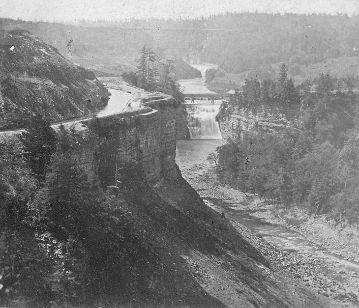
the bridge is visable at the top of this photo, a little lost in the haze in the distance, but you can make it out..
check out the canal hugging the side of the gorge!
the actual canal bed is still visable alongside the side of the trail just north of the "slide area"..
http://www.letchworthparkhistory.com/ip4.jpg
here are a bunch more fabulous photos!
http://www.letchworthparkhistory.com/lpa37.html
http://www.letchworthparkhistory.com/lpa24.html
http://www.letchworthparkhistory.com/lpa37.html
http://www.letchworthparkhistory.com/lpa86.html
and the entire photo collection:
http://www.letchworthparkhistory.com/Photo_Index.html
Scot
and before that, it was the Genesee Canal..
the bridge is visable at the top of this photo, a little lost in the haze in the distance, but you can make it out..
check out the canal hugging the side of the gorge!
the actual canal bed is still visable alongside the side of the trail just north of the "slide area"..
http://www.letchworthparkhistory.com/ip4.jpg
here are a bunch more fabulous photos!
http://www.letchworthparkhistory.com/lpa37.html
http://www.letchworthparkhistory.com/lpa24.html
http://www.letchworthparkhistory.com/lpa37.html
http://www.letchworthparkhistory.com/lpa86.html
and the entire photo collection:
http://www.letchworthparkhistory.com/Photo_Index.html
Scot

Thanks everyone for the information. Also, thanks for the tip, Otto, but the camera is a must since part of the reason we are there is to attend a wedding on Saturday. Scot the pictures are great! I will assume that the Genese Valley Canal/ PRR right of way is accessable from the parking area off Rte. 436 between Nunda and Portageville? Sounds like a good day trip!
dellacwes wrote:Thanks everyone for the information. Also, thanks for the tip, Otto, but the camera is a must since part of the reason we are there is to attend a wedding on Saturday. Scot the pictures are great! I will assume that the Genese Valley Canal/ PRR right of way is accessable from the parking area off Rte. 436 between Nunda and Portageville? Sounds like a good day trip!yes, that parking lot, right next to the old canal locks, is a great place to get on the trail..
but only if you have a mountain bike..its a bit of a walk on foot.
if you are on foot, you can access the trail much closer to the RR bridge by driving into the park entrance on the east side of the river.
on a bike, its a great ride!
park at the canal locks, and you can ride into the middle of the park..
all of a sudden the gorge is right there!
and the actual canal "ditch" is very visable in spots..
then you have to walk your bike through the "slide area"..
then you come back to the trail, and can ride out under the RR bridge..
Scot
Looking at those pic's, sort of got me lost. Is the canal on the west side or east side of the river? If west, is it the road that basically hugs the river, or the walking path? Been to Letchworth plenty of times, but not in like 10 years.
If NS replaces the bridge, will it be in the same spot, or span another part of the river? If they left the old bridge, convert it for walking and the view. Even if they tear it down and replace it, they should add a lane on the bridge for walkers and viewers with some sort of barrier fencing away from the tracks. People always go on the bridge
If NS replaces the bridge, will it be in the same spot, or span another part of the river? If they left the old bridge, convert it for walking and the view. Even if they tear it down and replace it, they should add a lane on the bridge for walkers and viewers with some sort of barrier fencing away from the tracks. People always go on the bridge
the canal was on the *east* side of the river..
the photos that show the canal on the left side of the photo, with the bridge in the background, are looking south..
the main, more developed side of the park, with the Glen Iris Inn and all that, is the west side of the river, opposite bank from the canal.
the canal came first, then the PRR built its Rochester branch along the canal path after the canal was abandoned, and today the PRR ROW is a walking/biking trail.
(Genesee Valley Greenway - http://www.fogvg.org/)
the East side of the park is not nearly as developed as the west side, btu there is a road you can drive into on the east side of the park to access the walking/biking trail.
walking on the bridge has *always* been illegal, but people have been doing it for well over 100 years anyway..
I have heard that NS is cracking down on it, at least more than Conrail did,
lots of new "no trespassing" signs are up..
I wouldnt recommend it..you CAN technically be arrested if you are caught!
If they do build a new bridge, its supposed to be slightly south of the existing bridge..
there is no way the railroad would ever allow an actual pedestrian walkway! not in our modern "sue everyone you can" society..
Scot
Scot