Railroad Forums 

  • Looking for track maps

  • General discussion of passenger rail systems not otherwise covered in the specific forums in this category, including high speed rail.
General discussion of passenger rail systems not otherwise covered in the specific forums in this category, including high speed rail.

Moderators: mtuandrew, gprimr1

 #1418359  by ALR997
 
Hello community,

first of all I should tell that English is not my native language. I am from Germany and as you will see in my writing my English is improvable ;-)

Actually I signed in to ask you for something I coudn't find on the internet: track maps (I hope you understand what I mean, it's about a map where exactly is shown where how many tracks are on a route).

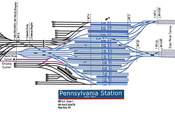
I found some parts of some stations (e.g. http://i1250.photobucket.com/albums/hh5 ... ra/NYP.jpg this one from New York Penn Station) in your forum, so I thought it's best just to ask if you know if I could find those anywhere listed on a website for other stations.

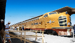
For now I am espacially interested in the Eastcoast, in detail the NYC-metropolitan area.

Last but not least: I hope I wrote this into the right forum. I'm new so if there is any problem please just say :-)

Best regards,
Lucas
 #1418376  by John_Perkowski
 
I'd suggest starting with USGS topographic maps. There's a lot of history as you go through their historical files.

https://viewer.nationalmap.gov/basic/?b ... Map%20View" onclick="window.open(this.href);return false;

I've drilled through Chicago in particular. There's a tremendous difference between the map in the 40s, especially in the area of La Salle St and Dearborn stations, and the map today.
 #1418575  by JayBee
 
I don't know of anything for the US like the Quail Track Diagrams for the United Kingdom. Some Employee Timetables(ETTs) have simple track diagrams and some don't. They are also much harder to obtain than they were in the past. Most of the companies now watch auction sites like E-Bay and have the auctions taken down as they claim the ETTs are for employee use only and belong to the company.
 #1418865  by Literalman
 
If you search in the DC - Maryland - Virginia Area Passenger Rail forum I think you can find track maps for the Washington, DC, Metro system.

And I couldn't find it just now, but somebody has produced a track map of New Jersey Transit.

And I think that the Northeast Corridor Future website has detailed track maps of the current Washington-Boston mainline.
 #1420639  by CP-4070
 
Where are you from in Germany?
New York metropolitan area is a huge thing if you include the freight and passenger operators out to the north, east and west. Also which era are you looking for?
 #1420660  by ExCon90
 
It appears that what you need is something like the Quail maps of Britain, or Schweers + Wall, and unfortunately we have nothing like that in the U. S. I wish we did.
 #1420710  by andrewjw
 
We used to have Richard E. Green's maps for several urban areas in the Northeast US, including NJT-SEPTA, MNRR, NYC (NJT-LIRR-MNRR), NEC in MD, and NEC in RI/CT. However these were taken down when he was hired several years ago and sold the rights to the maps to his employer, and they have not been legitimately available since.

That snippet you linked was created by someone taking a screenshot of one tiny piece of the NYC map.
 #1422689  by ALR997
 
CP-4070 wrote:Where are you from in Germany?
New York metropolitan area is a huge thing if you include the freight and passenger operators out to the north, east and west. Also which era are you looking for?
Hi CP-4070,

I am from near Essen but actually I am studying in Lower Saxony (a small University in south of Brunswick).

In general I am interested in track maps of anywhere in the US, but especially the main hubs as Penn Station and Grand Central Terminal in Manhattan or - a little more south DC Union Station.
Furthermore the mainlines as Northeast Corridor are interesting.

But, to make it a little more specific: thanks to Google Earth I can see the approximate location and number of tracks on the most routes. Problem are underground routes and stations, where you cannot see the course of the tracks (and so we have again Penn Station and GCT).

I found some very nice maps of New York Subway to start with, but I was curios if there are comparable maps of the real railway ;-)
 #1422690  by ALR997
 
Hi together,

I was a little distracted in february but I read your answers and wanted to thank you for your helpful tips :-)

Best regards
 #1449957  by GirlOnTheTrain
 
The maps there are not updated. You're better off getting a copy of Peter Dougherty's track map book (he did the maps on there) because he updates them yearly. You can go here for that: http://nyctrackbook.com/.

I have a physical copy of the 2016 version autographed by both the author and one of the contributors. It's a great book.