Railroad Forums 

  • Hampton Roads/Norfolk/Newport News NE Regional Service

  • Discussion related to Amtrak also known as the National Railroad Passenger Corp.
Discussion related to Amtrak also known as the National Railroad Passenger Corp.

Moderators: GirlOnTheTrain, mtuandrew, Tadman

 #1403965  by mtuandrew
 
Alright, so here's my best guess on the tunnels. For our purposes, I'm assuming that each tunnel will be 24' tall outside diameter, to allow 14.5' cars (I don't know the height from rail to ceiling - I'm assuming a 24' bore based on a RR.net conversation that gives the North River Tunnel boring shield's diameter as 23.5'.

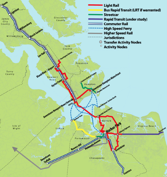
Naval Station Norfolk to Hampton: the main navigation channel (Norfolk Harbor Entrance Reach) has a depth of no less than 52.6 feet at mean lower low water (MLLW), but the depth over tunnel is no less than 59 feet. For our purposes, let's say a hypothetical railroad tunnel needs to stay no less than 65 feet under the surface at MLLW while in the main channel. Its path also crosses the Willoughby Channel appx halfway between Sewells Point and Rip Rap, but since that channel is only maintained to 10 feet we can assume the tunnel will pass under it easily.

The main navigation channel spans about 7500 feet, but we only need to maintain a 65' depth for 6000 feet before the channel walls begin to rise. For a hypothetical 2.5% grade and a station whose top is buried (say) 10' under Maryland Ave and Hampton Blvd, that puts us at about 2400' slope. Call it 3000' to be certain, and to include vertical and horizontal curvature. On the eastern side, we have about 4000' between Rip Rap and Sewells Point in which to gain those 55'. On the western, there's only 2000' between the tunnel portal island and mainland, so this tunnel's portal would have to be considerably inland.

That puts us at 4000' + 6000' + 3000' = 13,000', or about a 2.5 mile tunnel between Norfolk Naval Station and downtown Hampton. You might be able to reduce that somewhat if you don't try to use the existing tunnel portal islands, and tunnel under the navigation canal earlier.
 #1403969  by Ryand-Smith
 
They will never allow a tunnel to cross underneath the naval base. As it is now, all of your rail proposals are well, obsolete for 3 reasons. Reason one is the 3rd bridge tunnel. This will connect via the extended 564, via a highway corridor, to a tunnel. This tunnel, which will connect to craney island waste storage and infil storage will enable trucks to bypass the older hRBT. In 2030, when the HBRT receives more tubes, we should be maxed for capacity. The only commuter routes that make sense are a land and small water route from Norfolk to Portsmouth and then ending in downtown chesepeake. A heavy rail route would best be served by a trans James river rail bridge with a lift for destroyer movements up, connecting the Amtrak and CSX corridor to Norfolk instead of an exotic tunnel.
 #1403974  by mtuandrew
 
Ryand-Smith wrote:They will never allow a tunnel to cross underneath the naval base. As it is now, all of your rail proposals are well, obsolete for 3 reasons. Reason one is the 3rd bridge tunnel. This will connect via the extended 564, via a highway corridor, to a tunnel. This tunnel, which will connect to craney island waste storage and infil storage will enable trucks to bypass the older hRBT. In 2030, when the HBRT receives more tubes, we should be maxed for capacity.[/url]
I have my doubts about the Navy too, but was throwing it out as an option since it would also allow their sailors much easier access to base.
Ryand-Smith wrote:The only commuter routes that make sense are a land and small water route from Norfolk to Portsmouth and then ending in downtown chesepeake. A heavy rail route would best be served by a trans James river rail bridge with a lift for destroyer movements up, connecting the Amtrak and CSX corridor to Norfolk instead of an exotic tunnel.
I'm not sure I follow about the "land and small water route." Do you mean LRT and ferries?

Also, Trans-James from where to where - NPN to expanded Craneys? That doesn't get people into Norfolk proper, unless you include rail in the Third Crossing tunnel.
 #1404024  by Ryand-Smith
 
This route would go using the existing CSX tracks, cross the James river at a point, go through Isle of Right, and connect to the Norfolk Amtrak corridor. It would be expensive but much cheaper than building tunnels, since a bridge is cheaper than tunneling. The commuter route would be an expanded tide crossing the Elizabeth River at a point, going through Portsmouth to Chesapeake.
 #1404045  by Arlington
 
I'm going to drop this VaDRPT map in here, which is excerpted from the public meeting boards from while the TIDE was under construction and before Bland Blvd was chosen for Amtrak (in this plan, Oyster Point is the bus hub), and even before the new NFK station became "a thing".

Even though it has evolved since then, it has the bones of fairly good plan. Note that:
- "Bland Boulevard" is the new auto-centric / suburban transit center that seems to be going ahead (and I agree with critics that it is poorly located as "transit", since it leaves downtown NPN even worse served)
- Oyster Point is about halfway between the new Bland station and the current Amshack
- The current Amshack is located near the dotted border between Newport News and Hampton and where US 17 crosses the James (as a thin grey cross-James line)
- The future "Downtown" station is shown
- "Harbor Park" is the NFK Amtrak location.
Image
 #1404050  by deathtopumpkins
 
Wow, I never expected this to trigger this much discussion!

Arlington, that is the map I was alluding to with my previous post mentioning a tunnel connecting to proposed commuter rail on both ends. I always have a hard time finding that map again so I didn't bother trying to include it previously.

mtuandrew, thank you very much for doing the math on tunnel length. I think a 2.5 mile tunnel would be perfectly feasible to ventilate for diesels (with the hope of eventual electrification, at least for regional service). And while I'd like to include a Phoebus stop for any hypothetical regional service, downtown Hampton is still far enough inland that the tunnel would have time to surface before then.

Ryand-Smith, I think they would allow a tunnel underneath the base. Staying underneath Maryland Ave would mean it doesn't pass directly under any sensitive area. Also, bear in mind that I-564, Hampton Blvd, and Admiral Taussig Blvd all pass through the base with no restrictions whatsoever - and I-564 even passes directly underneath a runway! Someone could do a lot more damage from a box truck on 564 than they could do on board a train underneath Maryland Ave. I'm curious where the rest of your logic is coming from - the Third Crossing is still hypothetical, and probably not going anywhere, because it doesn't really help the HRBT. It might not have in the early 90s when it opened, but today the MMMBT has congestion issues itself, and is far enough out of the way that I don't think connecting to it from 564 via Craney Island would help the HRBT much, if at all. We really need more capacity on the Peninsula side. Also, note that the Third Crossing would also require tunneling underneath the base, which you say the Navy would never allow. Moving along, where are you pulling 2030 from? I think at this point it will be much later than 2030 before anything is done for the HRBT. I'm also not sure what you mean by a "land and small water route".
And your proposal for a bridge across the James would NEVER fly with the Navy. That's why the HRBT and MMMBT exist in the first place - the Navy vetoed any proposals to build a bridge over concerns that blowing up the bridge would block the harbor, trapping much of the Atlantic fleet. That's not likely to change. And building said bridge between Newport News and Isle of Wight County would be a mistake because it would be very far out of the way, and the river is very wide at that point. Plus unless you went all the way down to Suffolk, you'd also have to cross the Nansemond River.
 #1404051  by Arlington
 
Here's another "old study" map. This one showed using an alignment along US 17 to cross the James (presumably a bridge)
Image

While the source is Va DRPT, I'm fnding these on www.virginiaplaces.org
 #1404061  by Ryand-Smith
 
I am on base right now, and am confused. The reason why the cheap option, the high bridge between Hampton and Norfolk will never be a thing is because it traps the fleet. There can be bridges built over the James, because well.. nothing critical navy wise is caught there (the only upstream naval base is on the other side at Yorktown at the naval weapons base and that is where the 17 bridge is a swing span.)

Also, the third crossing (I can see the site where they are proposing building it and I talked to the VDOt people is on non navy property. It is on a small strip that seperates the base from the port, which was one of the of details that would enable the navy to not veto the current proposals.

(Also the MMBRT has congestion for at most 4 hours a day, while the HBRT is approaching 12 hours of congestion. There is a reason why alternative A, the "build more HBRT" is getting pushed as the local alternative, the HBRT is more limiting than the MMBRT. The traffic studies will push more traffic into the underultized northbound MMBRT, (because the vast majority of traffic is yard workers going to cheaper Suffolk/Chesapeake/Virginia beach when the first yard shift lets out, the third crossing would relieve workers from Norfolk and the base who live on the peninsula.)

All of this data is from the public study they released and I went to about the alternatives for traffic study VDOT did. The limiting factors for Atlantic fleet are the HBRT and the Chesapeake bridge tunnel, which is why those are well.. bridge tunnels. Barges go up the James river and the MMBRT is a bridge tunnel because the Newport News shipyards are tre limiting factor for that side of the peninsula.


Edit, Arlington literally posted exactly my proposed map. Thanks!
 #1404064  by Station Aficionado
 
A bridge paralleling the current James River Bridge (Rte. 17) would require 15-20 miles of new ROW south of the river to reach NS at or west of Suffolk, or else building another bridge across the Nansemond and then acquiring ROW through a much more built up area to reach NS at Bowers Hill. Also, I believe there are wetlands on the south shore. I am clearly no railroad engineer, but it looks to me like it would require a heck of a (probably very slow speed) curve on the north side of the river to connect to CSX, not to mention acquisition costs for the bridge approach. As for bridge height, there is the ghost fleet up the James (although I'm not sure how many ships are there now). And are we sure that it is only barges that go up to the piers at Hopewell and Richmond? Given all of that, I'm not at all sure that the bridge has the cost advantage that you assume.
 #1404134  by electricron
 
Arlington wrote:Here's another "old study" map. This one showed using an alignment along US 17 to cross the James (presumably a bridge)

While the source is Va DRPT, I'm fnding these on www.virginiaplaces.org
Interesting proposal for a FRA compliant railroad connection between Newport News and Norfolk, using as much of the existing freight railroad right-of-ways as possible, making it as cheap as possible to implement. Except the existing arrangement, using two different railroad corridor from Richmond is already implemented. No new costs at all, except for maintain what is already in place.
Implementing this proposal doesn't improve long distance, or NEC regional train passengers services at all. It only improves services for local Norfolk to Newport News passengers, which probably will be better served with light rail trains.
 #1404190  by deathtopumpkins
 
My comment about the Navy not allowing a bridge was for across the harbor, not farther upstream. I even said it was for the exact same reason you just said - trapping the fleet. They would allow one farther upstream (as evidenced by the JRB). However, as I pointed out, a new rail bridge parallel to the JRB would be VERY long, and require lengthy ROW acquisition on the south side. Also, note that the JRB is a lift bridge, not a swing span.

As for the Third Crossing route being south of the base - I assume the option they're proceeding with is the one following the NIT rail line then, branching off of 564? That would cross under Pier 3 of NIT rather than the base. I'll admit I haven't followed planning as closely since I moved away from Hampton Roads a few years ago, but last I heard they were still studying alternatives.

Finally, I apologize if this comes across as petty, but it bothers me: the relevant crossings are the Hampton Roads Bridge-Tunnel (HRBT), the Monitor-Merrimac Memorial Bridge-Tunnel (MMMBT) and Chesapeake Bay Bridge-Tunnel (CBBT).
 #1404191  by deathtopumpkins
 
electricron wrote: Interesting proposal for a FRA compliant railroad connection between Newport News and Norfolk, using as much of the existing freight railroad right-of-ways as possible, making it as cheap as possible to implement. Except the existing arrangement, using two different railroad corridor from Richmond is already implemented. No new costs at all, except for maintain what is already in place.
Implementing this proposal doesn't improve long distance, or NEC regional train passengers services at all. It only improves services for local Norfolk to Newport News passengers, which probably will be better served with light rail trains.
I would argue that it does improve regional train service significantly, by allowing Amtrak to serve BOTH NPN and NFK with EACH train, rather than splitting them. Instead of 3 NPN trains and 1 NFK train, you'd get 4 trains stopping at both. More frequencies almost always translate to more ridership. It would also allow Amtrak to eliminate the Thruway buses from NPN.

As I've said before, it does also improve service for local passengers if a regional commuter service (tying into the VADRPT proposed lines on either side) is overlaid onto it as well, but it's not exclusive. A cross-harbor heavy rail service improves BOTH Amtrak and local/regional service, and I think would do wonders for the Hampton Roads economy.
 #1404210  by mtuandrew
 
Connor: hard to justify a cross-harbor rail tunnel for 4x/day, or even 16x/day if we add commuter rail. Until we surpass (say) 30x/day, fast ferries become a far better option, with fast LRT in the future. I kind of grudgingly like the VaDRPT plan (assuming we have more than 4 frequencies), since it catches Suffolk too. Our proposals don't do that, except for commuter rail or rapid transit which we haven't discussed.
 #1404214  by Station Aficionado
 
From a purely intercity/Amtrak perspective, Ron's point is well taken. There is only so much money available for intercity rail in Virginia. A bridge or tunnel to bring Amtrak from Newport News to Norfolk would be way down on the priority list. Between what exists now and already planned improvements (IIRC, the state wants 3x to Newport News and 3x (or is it 6x) to Norfolk. Since those trains all go on to DC and New York, the incremental improvement from direct NPN-Norfolk service would be minimal (only additional city pairs would be Norfolk-NPN and Norfolk-Williamsburg, while losing Norfolk-Petersburg). And the current trains are already well patronized. There simply is a not a significant benefit to justify the cost for intercity trains. Another instance, I think, where we shouldn't try to make the perfect the enemy of the good.
  • 1
  • 42
  • 43
  • 44
  • 45
  • 46
  • 49