Railroad Forums 

  • When Did They Go Fron Dble Track To Single?

  • Discussion of the past and present operations of the Long Island Rail Road.
Discussion of the past and present operations of the Long Island Rail Road.

Moderator: Liquidcamphor

 #320699  by One of One-Sixty
 
I was doing some research and notice that the LIRR out to Patchogue was actually doubled tracked, and then in at some point it was only doubled tracked from River Ave to Potter Ave. It was still like this in 1958 and then some time between that time and 1999 it was cut back completely to a Single track except for tehh siding and run-around.

When did the LIRR decide to cut back from double track to single in this area? ANd why?

 #320763  by Dave Keller
 
The LIRR was NEVER double tracked beyond east of Sayville ("Y" interlocking).

And "Y" interlocking cabin and block station was manned until 1939 when a spring switch was installed and the block signal controlled from distant "PD" tower.

And the "double track" you see through the depot area of "old Patchogue" wasn't "double track" but sidings.

The one south of the main started just west of River Avenue, and was called the "Ringhouse siding". It continued to just west of Railroad Ave. where it came back into the main again.

The one north of the main (still in place with "new Patchogue" - post 1963) started just on the east side of the bridge over the Patchogue River and extended to just west of Potter Ave. That was called the "North Siding" or "Schoolhouse Track."

Where did you find this false information about double tracking?

Dave

 #320795  by One of One-Sixty
 
it came from a Lirr site that I stumbled across while trying to find a nice section of the LIRR to make a model of.

 #321070  by Dave Keller
 
Beware what you read on the internet.

If you want to know the truth about a topic, always go to someone you know who is reputable.

This is the MAIN reason why I put all sorts of data on my website and why I try to answer ALL the questions I'm able . . . . . so mis-information, rumor and hearsay doesn't one day become "truth."

Dave

 #321075  by Noel Weaver
 
Dave Keller wrote:Beware what you read on the internet.

If you want to know the truth about a topic, always go to someone you know who is reputable.

This is the MAIN reason why I put all sorts of data on my website and why I try to answer ALL the questions I'm able . . . . . so mis-information, rumor and hearsay doesn't one day become "truth."

Dave
This is a very good point that I fully agree with. One more thing, be wary
of what you read in books too, they can be good but they can also be
full of errors. Some people take as "gospel" what they read in a book but
sometimes it is all wrong.
Noel Weaver

 #322301  by Dave Keller
 
Wikipedia is filled with data that is provided by people who send in said data.

It is not researched data.

Therefore, it should not be taken as true.

These are the same kind of people who argue with me about a topic I've researched and studied for 40+ years . . . . but they think they're right.

I like to tell them: "Hey, buddy! Go read a friggin' book once in a while!"

After all . . . I wasn't born this smart! ;-)

DK

 #324718  by nyandw
 
One of One-Sixty:

Noel and Dave are spot on:

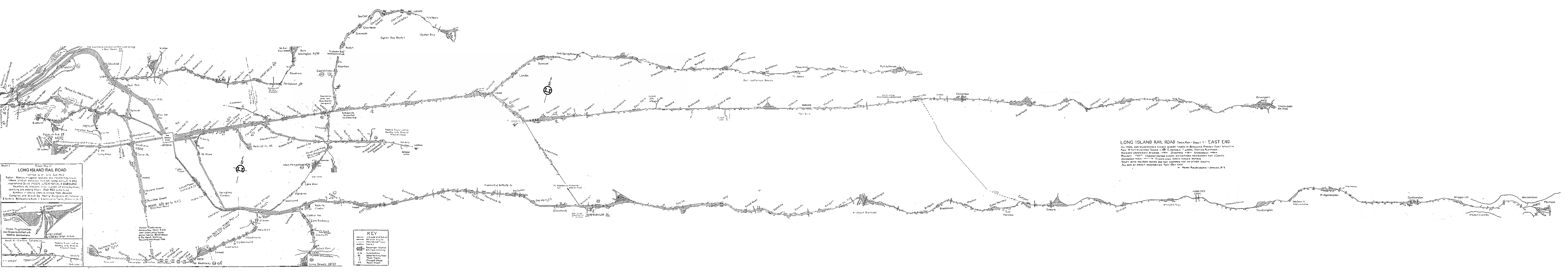
http://www.trainsarefun.com/lirr/images ... nd1952.gif shows end of double track after Sayville. This hand drawn map was walked and is very accurate as it matches other sources; topo maps, LIRR blueprints, Emery maps, LIRR instruction books, etc.

Dave Keller: "....Wikipedia is filled with data that is provided by people who send in said data..." and he is correct that it has much false/unverified data. In the data processing business and insurance business we tell all our staff to ignore/be very skeptical, etc.

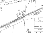
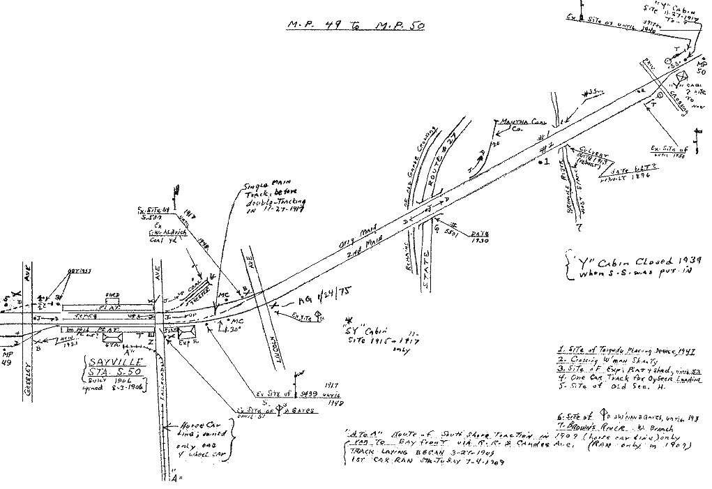
http://www.trainsarefun.com/lirr/sayvil ... P49-50.jpg
here at MP50 you can see the double track go single.

LIRR c. 1950 map show the single main line turning into two tracks (Ringhouse siding) as Keller indicated.

http://www.trainsarefun.com/lirr/patcho ... 201958.jpg
Patchogue MP53 indicates single track into the double track Patchogue yard.

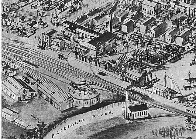
http://www.trainsarefun.com/lirr/patcho ... lyards.jpg The popular panorama map of the time c. 1904-06 show a single track. They are very accurately drawn. My ex-Patchogue house had the correct windows, porch and shed on the map exact.

One of One-Sixty:

Your trying to find a nice section of the LIRR to make a model of. Drop me an email and I'll have a chat with you. :-D

I wrote a magazine article about Oyster Bay: http://www.trainsarefun.com/lirr/oyster ... irrob2.htm

I have an LIRR modeling site; http://www.trainsarefun.com/modeling/modelingmain.htm

Patchogue is fabulous with all its industry, turntable, roundhouse, etc. I have an article to do in the future...

The Bay Ridge Branch has interesting possibilities.

And several fellows are doing the Bushwick section:
http://www.trainsarefun.com/lirr/bushwick/bushwick.htm
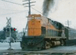
 #330178  by bingdude
 
What's misleading about this is the double-track wide bridge over one of the streets in Bayport (I've forgotten which).

After seeing that, one could make an incorrect assumption.

 #330191  by Dave Keller
 
There were numerous bridges on the LIRR's system that were double track width, to carry the passing siding over a main cross street.

The trestle at Medford over Rt. 112 had two tracks to accomodate the passing siding there as well.

Dave

 #330248  by bat@grumman
 
I believe the bridge over Deer Park Ave. carries a siding as well. -Pat

 #330278  by GP38
 
bingdude wrote:What's misleading about this is the double-track wide bridge over one of the streets in Bayport (I've forgotten which).

After seeing that, one could make an incorrect assumption.
You are thinking of the Blue Point AVenue bridge in Blue Point, where the old Blue Point station used to be. It's double tracked because there used to be a freight siding in the old station, just like most stations had freight/passing sidings in them. Bayport also had a double track in the station for a siding too. Medford's Route 112 bridge is also double wide.

Unfortunately, some people see these old freight and passing sidings and incorrectly just assume that these sidings or remnants of these sidings are evidence of what was once a second running track. On the Montauk Branch the double track never went further than it ends right now, between Sayville and Bayport.

 #330322  by nyandw
 
GP38 wrote:
bingdude wrote:What's misleading about this is the double-track wide bridge over one of the streets in Bayport (I've forgotten which). After seeing that, one could make an incorrect assumption.
GP38 is sure right!
Image
http://www.trainsarefun.com/lirr/images ... nd1952.gif


is a very accurate map showing single track in the area with sidings for example.

Here's the Sanborn for 1938 Bayport as "GP38" indicates:
Image
http://www.trainsarefun.com/maps/bayport1938.gif


Best,