• A mystery B&M photo, c.1918

  • Discussion relating to the pre-1983 B&M and MEC railroads. For current operations, please see the Pan Am Railways Forum.
Discussion relating to the pre-1983 B&M and MEC railroads. For current operations, please see the Pan Am Railways Forum.

Moderator: MEC407

  by BigLou80
 
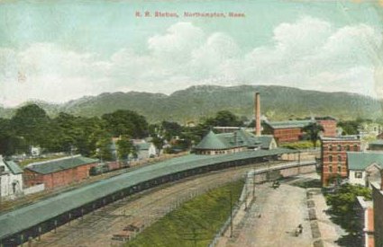
Leo Sullivan wrote: The picture of train 25 was taken at the farthest corner of the station, completely obscured in
the 1909 picture. The chimney might be behind the highest part of the roof. It might also have
been built in 1910. I did Google street level and Hawley St. is as completely re developed as
any I've seen so, no help there. I believe the picture was taken at Northampton because I
can't find anyplace else that fits as well but, admit, final proof is lacking, without a site
visit or local knowledge.
LS
Im going to have to disagree. I'm 99% (but not 100%) sure its not Northampton. To many large prominent buildings visible in the picture to assume they were all torn down when hawley street was "re developed" assuming it was ever developed during the time of the picture in question. There are two steeple esque things to the right of the photo and one to the left as well as the windowed cupola and mansard roofed building. There is no evidence of any of those structures in Northampton. I did however (where the 1% comes from) find a post card showing a similar building with a smoke stack to the south of the station where there is now a parking lot.
http://www.lightlink.com/sglap3/massach ... olpost.jpg

I also think the Mt in the picture is to small considering you would get the whole range not just one hill. My final vote against Northampton is the building density in the picture seems off for that part of Northampton even today. It looks more downtown then river plains. The current layout of hawley street seems to far away to work for that picture. But like I said im only 99% sure so I could be all wrong
  by Leo Sullivan
 
I must say that if we get this picture pinned down, it will be very definite.
I have to go through Northampton Friday and. will definitely spend a little time
looking at the scene and some archives.
As for Hawley St. Remember the picture is much closer than any of the postcards.
Hawley St. did have many factories and much factory housing and, seems to be rather
famous for fires and redevelopment. I suspect that very little of Hawley St. has
survived since 1920. Wiil report after my visit.
LS
  by BigLou80
 
TO the OP,
Did you ever look in to places where your father might have been traveling that year to give us a clue as to where the picture may be ?
  by BigLou80
 
Leo Sullivan wrote:I must say that if we get this picture pinned down, it will be very definite.
I have to go through Northampton Friday and. will definitely spend a little time
looking at the scene and some archives.
As for Hawley St. Remember the picture is much closer than any of the postcards.
Hawley St. did have many factories and much factory housing and, seems to be rather
famous for fires and redevelopment. I suspect that very little of Hawley St. has
survived since 1920. Wiil report after my visit.
LS
actually accoring to zillow a good part of hawley street and surrounding streets dates to the 1900 era, which is typical for this area. I drove down pearl street via rt5 north on monday and it didn't seem to fit but I didn't actually go in to the parking lot and look around. Snap some pictures from the parking lot looking due south and lets see it we can make a match

http://www.zillow.com/homedetails/61-Ha ... 3781_zpid/
  by jaymac
 
"Images of America: Northampton" (the italics function still doesn't) shows on p. 41 a photo of the Belding Brothers Silk Mill on Hawley Street, next to the not-yet separated ROW. The archictecture of the mill agrees in its particulars both with the original photo for this thread and with "The Central Mass," photo discussed somewhat later, and is the diagonal opposite, showing the front of the building. Hawley Street is still surfable on GEarth, and there are some now empty or redeveloped places that could have been the mill site.
A cursory web search yields many hits for Belding because they had a large number of facilities, but no immediately obvious history for the Northampton mill. The Depression caused lots of cut-backs, particularly in luxury materials like silk, and given the design with skylights and lack of any obvious firestops, if that building ever caught fire, it would have quickly collapsed.
  by Leo Sullivan
 
Jaymac has already posted about the silk mill so, that's not news but, I did
find two buildings that matched. I should have walked farther south so they
would line up the same but, here they are. The Cupola is very distinctive and,
I believe the brick building is the same with 90 years of alterations. the peaked roof,
in the original picture
is on a departed building behind. locals confirmed that there was much more
on Hawley St. before the war and told me about the silk mill.
You do not have the required permissions to view the files attached to this post.
  by BigLou80
 
Leo,
It very well could be I have been wrong before. Did you have any luck finding any of the steeples or the mansard roof building ?
  by Leo Sullivan
 
The mansard roof building is definitely gone and, I really looked for it all around in case I
was wrongly oriented. The higher hills are now behind trees but, they are visible through
the trees in one of the new pictures. There are lots of vacant lots on Hawley St. the second picture
shows new buildings where the big mill was. I didn't find out its' fate but, locals had
heard of it and said "yeah, that's it". Any place else in Northampton would have been easy,
The scene on the Pearl St. side is not much different from 1909 and, is in BigLou's linked
postcard with the mill in the background. I'm satisfied. I'd better be, I won't get back there for months.
You do not have the required permissions to view the files attached to this post.
  by brbrown99
 
I would have to say that it is Northampton.
The track curve is correct for a northbound train and older maps show at least 3 tracks at that location.
When looking at the larger picture that was attached later in the thread a couple of things stood out:
1. The shape of the mountain in the background matches Mt. Holyoke.
2. The building at far right (with the cupola) is a match for an existing building on Halwey St.

So based on that, I'd say the photographer is standing on the east side of where Spagetti Freddy's is today facing southeast towards Mt. Holyoke...
You do not have the required permissions to view the files attached to this post.
  by Eliphaz
 
I must say I am thrilled that you guys have taken such an interest in this question, and done the legwork to see it through!
My thanks especially to Mr. Sullivan. I am embarassed to say I go by Northampton on I-91 regularly on my commute to work, but I havent brought myself to stop and look at the station.

On further study of the scrapbook, I have come to believe the year is 1916, rather than 1918.
I have begun a photobucket album here http://s894.photobucket.com/albums/ac14 ... %20photos/
which I invite readers to peruse and comment on, though none are railroad related.
unfortunately photobucket has recently "upgraded" the software , so it is an infuriatingly slow process.
  by ferroequinarchaeologist
 
Things are getting bad when you have to quote yourself:

>>According to a 1916 Official Guide, Train 25 was a Fitchburg Division train, leaving Boston 3:40 am and arriving Troy, NY 11:05 am<<

Hmm. OK, let's say it's Northampton - the distinctive cupola is a strong argument. Can anybody explain what Train 25 - a Fitchburg Division train - is doing in Northampton?

PBM
  by BigLou80
 
ferroequinarchaeologist wrote:Things are getting bad when you have to quote yourself:

>>According to a 1916 Official Guide, Train 25 was a Fitchburg Division train, leaving Boston 3:40 am and arriving Troy, NY 11:05 am<<

Hmm. OK, let's say it's Northampton - the distinctive cupola is a strong argument. Can anybody explain what Train 25 - a Fitchburg Division train - is doing in Northampton?

PBM
The reality is we will never know unless some how another photo looking that way appears. The cuplola building is not all that distinctive. I can think of at least one other located in Brattleboro Vt.

What is missing from the new pictures is all of the steeples along with several other buildings. I guess we will never know
  by Leo Sullivan
 
I'm not going to deny that BigLou has grounds for doubt. i made a couple (at least)
of mistakes. I didn't know that each division had its' own train numbers so, Fitchburg Div. 25 and
C&P div 25 both existed (and went through Greenfield!!)
Conn river 25 arrived at Northampton at 1:48 pm so. probably never saw Fitchburg 25.
I also forgot that train numbers didn't stay put so, since we don't know the date we don't
know much (there is no #25 on the Conn. river in 1923 etc.) All the stuff that will or will not
answer the question is pretty interesting so, no trouble and, i learned a lot. Hope everyone else did too.
i suspect there are other pictures we haven't seen and, if anyone sees a good one, I hope they remember
this thread.
Good hunting
LS
PS- i do think it is Northampton but, no bets yet.
  by 3rdrail
 
Just a couple of thoughts. It's curious that a site which is pictured as large as this one is hasn't been positively identified by someone so far. Man-made structures change over time, but usually mountain's profiles don't. Would it be possible for somebody to get in back of the trees which apparently are covering up the range that exists now at this site and photograph the range so that it's profile may be compared with the original photograph's ? A striking similiarity in profile, even from a slightly different angle, would almost certainly positively identify this as being Northampton if indeed it is. Likewise, a shift in direction would point us in the right direction also, as it would give us reference from Northampton.

My second thought is that considering this unexplainable identification problem presently, could it's reason for elusiveness be the fact that it now sits in the midst of the water which comes out of our faucets ? Could this be a built up town flooded to build the Quabbin Reservoir, and could this be a Boston & Albany consist on the Athol Branch ?
  by eddiebehr
 
No it is not the Athol Branch of the B & A. Greenwich, Enfield, Dana and Prescott did not have any mammoth structures like those shown in photo or such a large amount of track in one spot. When much of Massachusetts was devoted to agricultural and logging pursuits, much of the land was cut over. Now that those endeavors are very minimal much of the land that was bare in 1915 is overgrown today. Back in 1915 virtually only public parks and better residential neighborhoods had trees and they were well manicured. Today there are State Parks and Reservations, town and city conservation lands and even some privately owned reservations. You would be hard pressed to try and make a case using the natural surroundings. You are better off looking at buildings and street layouts. I've lived in the same house since I was 3 (1947) and the wide open fields behind the house, which were once pasture were either developed or became town conservation land. The family photos of folks with the pasture behind them could not be recognized today except for my house and a large elm. The conservation land is right behind me and there are development houses (built 1955) 500 or so feet behind my house. The brush, maple, birch and some other types is so thick that only during winter can one spot the glimmer of a streetlight or house light beyond the conservation area. So using natural features is not a very good indicator of where you are. I ran the property records area of the Boston & Maine, 1973-85 and we had some old photos taken 1914-1915. Back then the brush on rights-of-way, even branches, was cut back to the property line which on many lines was either 33 or 41.25 feet back from either side of the centerline. Even mainlines today only get sporadic brush cutting, often in response to FRA orders. Find one of those H. W. Pontin photos taken of the Boston & Albany trains by the Leo Martin Golf Course or near Faneuil with the Perkins School in the background. Then go out in summer and compare today versus the mid-1930s or a few years later.