Railroad Forums 

  • 1970s Photos of Rochester

  • Pertaining to all railroading subjects, past and present, in New York State.
Pertaining to all railroading subjects, past and present, in New York State.

Moderator: Otto Vondrak

 #1357899  by Conrail6467
 
Hey guys, I am in need of a little help. I am trying to compile photos for my future layout (Still in Development) that models Rochester in the fall of '76. I will take any B&O, PC and Conrail photos between '75 and '77. Specifically, I need Charlotte photos and the Branch up to Beebe. I have no idea what it should even look like because I wasn't alive. Being 15 makes modeling 1976 a little bit difficult. Anything you can give me would be great. I appreciate it. I love how I can just lean on you guys when I'm in a pinch. That is what is so unique about the railfan community. - Josh
 #1357965  by brockwaythemusician
 
There is a group on Facebook called "railroad rambler" that is upstate NY based and has a bunch of pictures posted of the Rochester area but a little later than your era 1980-89. Penn Central in color volume 1 also has a few good pictures from the '70's including 2 or 3 from 1975-76.
 #1357979  by Conrail6467
 
Thanks for the recommendations. I have seen alot of
Good stuff from local railfans with slides posted from that era. Any Charlotte or mainline control point shots, especially the track layout and signals, would be extremely helpful. Trying to make the scene as of you were there at that time. Thanks!!
 #1357992  by Otto Vondrak
 
Conrail6467 wrote:Specifically, I need Charlotte photos and the Branch up to Beebe. I have no idea what it should even look like because I wasn't alive.
How large a layout are you constructing? What scenes are you modeling? What do you need photos of specifically? The scenes themselves haven't changed all that much. Plenty of photos of the Hojack swing bridge before it came down. You can walk the path where the rails were today and see the same scenes. Google Earth views should help you out, too.

-otto-
 #1358003  by Conrail6467
 
Otto Vondrak wrote:
Conrail6467 wrote:Specifically, I need Charlotte photos and the Branch up to Beebe. I have no idea what it should even look like because I wasn't alive.
How large a layout are you constructing? What scenes are you modeling? What do you need photos of specifically? The scenes themselves haven't changed all that much. Plenty of photos of the Hojack swing bridge before it came down. You can walk the path where the rails were today and see the same scenes. Google Earth views should help you out, too.

-otto-
Thanks Otto. The goal was to start from CP-373 and then model the Hojack east and west. When im older and feel like it, I hopefully will expand to the mainline and eventually from Newark to Batavia.
 #1358015  by BR&P
 
That sounds a bit over-ambitious, unless you happen to have a spare warehouse or unused airplane hanger to build in. Just getting from CP35 / CP373 to Charlotte would be a challenge. To add in the Hojack in both directions, plus the main line......unless you hit the Powerball, I think you need to scale back your objectives a bit. Just my 2 cents worth.
 #1358021  by charlie6017
 
Hi Josh,

I was going to ask you if and how you were thinking of planning the wyes at 373 and Otis (Falls Road/Charlotte Branch split) into
the layout? Were you thinking of modeling the far eastern end of the Falls Road branch, say from Lee Road or Mt. Read Blvd?

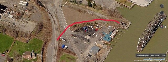
I did a bunch of screen captures of Birds-eye views of the areas you want to model and also show where the wye area was in
Charlotte for entry-way onto the old swing bridge. I'm glad the current birds-eye view still has that bridge in place for posterity.

Below is the area where the wye was in Charlotte. You can see where I crudely drew the curve where the east side of
the wye was.

Image
 #1358023  by Conrail6467
 
Thanks for the advice. Now thinking about it, I am probably going to stick to The Charlotte Branch and the Hojack east and west, and very possibly a little bit of Otis, the East Falls Road, and MAYBE the coal docks . More interesting to show the crudity of the line in that time, plus the infinite switching possibilities. From what I read and saw in that 71 study of it by PC it sounds like it was sprawling but it didn't get much attention. I appreciate the help with the drawing. Just a few questions: Where were these supposed Diamonds on the Charlotte Branch? (It would help to see more drawings), especially old maps. I am confused as to where the North and South yards are in Charlotte. I am so excited to get started but I don't know where to start. I really appreciate the help guys. Thanks

-Josh
 #1358047  by bwparker1
 
Conrail6467 wrote:Hey guys, I am in need of a little help. I am trying to compile photos for my future layout (Still in Development) that models Rochester in the fall of '76. I will take any B&O, PC and Conrail photos between '75 and '77. Specifically, I need Charlotte photos and the Branch up to Beebe. I have no idea what it should even look like because I wasn't alive. Being 15 makes modeling 1976 a little bit difficult. Anything you can give me would be great. I appreciate it. I love how I can just lean on you guys when I'm in a pinch. That is what is so unique about the railfan community. - Josh
Here!!! Best Rochester Photos ever that I have seen online.

https://www.flickr.com/photos/duncanric ... 736756336/" onclick="window.open(this.href);return false;
 #1358117  by ctclark1
 
charlie6017 wrote:Below is the area where the wye was in Charlotte. You can see where I crudely drew the curve where the east side of
the wye was.

Image
Josh, If you're trying to stick to true to reality, this was a crossover Y - to head to the swingbridge from the south you actually took the left alignment of the switch and crossed back over the other leg of the Y to get there, something I think was somewhat rare, and pretty unique in my opinion - it's actually something I'm trying to figure out how to incorporate into my fantasy layout in Trainz.

See here (Also happens to be a shot with the bridge closed...)

This site might actually come in handy for you to see the layout in the past as well... Good luck!
 #1358127  by lvrr325
 
1976 is going to be mostly PC power, patched and unpatched, primarily RS32s, RS11s, RS2/RS3's, with some EMD (GP7, GP9, GP30, GP35) and GE (B-boats) power and some EL/LV/RDG power scattered about, patched and unpatched. Same deal with cabooses, primarily ex-PC. There's a lot of pictures of Rochester-based locals out there to look at.
 #1358137  by Conrail6467
 
Thanks Alot guys. These references are gold. What kind of industry base were they looking at for the west? Ex. Hilton, Hamlin, Walker.. I know what the industries were on the East Hojack because I have the '71 study of the east hojack by Penn Central.
 #1358147  by charlie6017
 
Conrail6467 wrote:Thanks Alot guys. These references are gold. What kind of industry base were they looking at for the west? Ex. Hilton, Hamlin, Walker.. I know what the industries were on the East Hojack because I have the '71 study of the east hojack by Penn Central.
In that time period (1968-76), traffic was sparse but the "big" customer was in Hamlin with Duffy-Mott. If I remember
right, they closed in 1977 and that sealed the fate of that line. I don't believe any traffic existed in Hilton, Walker or
anywhere else between Hamlin and Charlotte at that time but I'll let others confirm.

A number of years back, I know the cold storage in Hilton (off Canning Street) was a good customer but I don't
know when they stopped receiving service. There also was a cold storage in Hamlin and off Collamer Road just
west of Hilton a long time ago. Depending on how much room you have to build, those buildings could be modeled
and maybe some "scarred land" where the tracks used to be? Just an idea.

Hope this helps! :-D

Charlie