Railroad Forums 

  • Charlestown/Everett Elevated Question

  • Discussion relating to commuter rail, light rail, and subway operations of the MBTA.
Discussion relating to commuter rail, light rail, and subway operations of the MBTA.

Moderators: sery2831, CRail

 #767386  by JohnK
 
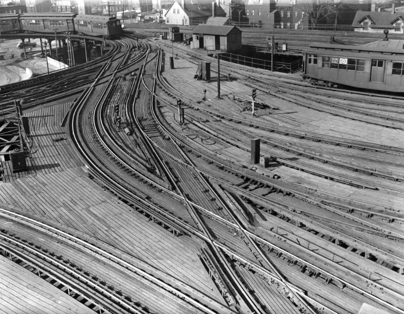
When an Everett-bound Orange Line train would leave the [old] Sullivan Square Station, it took a sharp right turn. I remember this turn, but, don't remember much of the details. (I rode the El regularly with my father in the 2 to 3 years before it closed. I was on the "last ride" in 1975; I was 3-1/2 years old on the last trip! I remember much of the route and have many memories my rides on it, but many details now escape me of the physical structure of the El......I am trying to reconcile my memory vs. existing photos that I can find). Some photos confuse me a little because they're "not what I remember".

My question: on the right turn coming out of Sullivan, did the route to Everett go through one corner of the shops? Or, had part of the original 1901 shops been removed to accomodate the line to Everett? The original 1901 shops (as seen in the book "When Boston Rode the El") look like they would have had to have a corner cut off of them, in order for the curve on the line to Everett to be able to pass by the shops.

Also, there was a stone incline for trolleys on Beacham Street. Trolleys took a right turn out of the south side of Sullivan, went over Beacham Street, and descended down to Beacham Street on a stone incline that was right up against the brick shop building. Was this incline present right through to 1975, and, were the tracks still on it?

Was anyone else here on the last ride from Everett? I was the 3-1/2 year old blonde kid with his father.

Thank you.

-John K.
 #767398  by dieciduej
 
As far as my memory the route to Everett did not go through the Beacham St. Shop but it did run through the Beacham St. Yard. The book "Streetcar Lines of the Hub" pg 150 shows a map of it.

I was ten back in '75. I do remember seeing a steeple cab locomotive coming up the incline and pulling into Sullivan Sq station. For my family Sullivan Sq was the last stop the on to the Elm St bus. Everett was for visits to the grandparents.

JoeD
 #767664  by dieciduej
 
JohnK wrote: Also, there was a stone incline for trolleys on Beacham Street. Trolleys took a right turn out of the south side of Sullivan, went over Beacham Street, and descended down to Beacham Street on a stone incline that was right up against the brick shop building. Was this incline present right through to 1975, and, were the tracks still on it?
-John K.
I found this photo at Dave's Rail Pix, http://www.davesrailpix.com/boston/htm/bos472.htm, which shows the incline. At a quick glance the white car next to the ramp is a '73 or '74 Chevy Impala station wagon. So my guess would be it made it to the end or close to it.

JoeD
 #767690  by JohnK
 
Wow, this is great, thanks so much.

When comparing this to the original 1901 shop photos I have seen, it is seen that substantial parts of the original shop were "chopped off" to make way for the yards above Beacham Street and the line to Everett. That is, the yards and the Everett mainline travel right through where parts of the shop used to be.

I wish it had lasted just a little longer so that I would have better memories of it. The line was a lot of fun.

Thank you.

Was anyone on this board on Everett's "last ride"?

-John K.
 #767906  by Leo Sullivan
 
Quite a large piece of the shops was demolished to make a reasonable curve for the Everett
extension as others have noted. The Beacham St. incline, was used by surface cars headed
for Everett and beyond. After the Everett extension was opened, it was no longer necessary
and was used by work cars. Often the work car, usually a box motor,which had trolley poles,
and a flat, would go to the
Arlington Ave. material yard to pick up rail etc. then up the incline into the one remaining
surface stub track, reverse, then cross over to the Rapid Transit and go to that night's work site.
The single track remaining on the ramp was used until the end of El service and possibly
for a while after as, any material removed by rail would have to go out that way,
The enclosed picture shows the north side, with the five surface tracks and the interchange with the El.
The right hand track remained to the end.
There were offices on the rest of the site where the other tracks had been and the rails, never removed, made the floor covering uneven.
LS
 #769099  by GreenLinetoBrooklyn
 
So this is semi-unrelated to the OP, but Ive been wondering this for a while and it definitely falls under the El category.

Where was the original Sullivan Square located and how was it oriented? From the nyctransit photos I can deduce that it was somewhere very close to the Schraftt Center, probably on its northern side with tracks coming from Main St to the ~west. That'd put the original station on top of Alford St, just outside the big roundabout.

However, that roundabout wasn't there back in the days of the original station was it? I used to work in the Schraftt Center and every day walking around the roundabout I wondered about the big cement walls coming off 99. Those couldn't be from the station, right? Does anyone know what they were? Are there any remnants of the old station left?

Anyways, cheers and thanks for the responses! pictures of course welcome (when aren't they?)!
 #769126  by dieciduej
 
Here is an image of a Google map with the approximate location of Sullivan Sq Station. I do not have my references with me to give a better representation.

JoeD
Attachments:
Approximate location of the old Sullivan Sq Station
Old Sullivan Sq Location.jpg (92.19 KiB) Viewed 8286 times
 #769140  by dieciduej
 
BostonUrbEx wrote:Wasn't that a MA-99 & I-93 connector ROW right where those parking lots are? Did the El run over or under it?
Where the parking lots are was the incline to the old Rutherford Ave. flyover, so you would bypass the Schrafft Circle, as I call it. The was beside it. Looking from the new Sullivan Sq the flyover was in front of the old Sullivan Sq. I do not remember it connecting into I-93. Remember the El went up Main St.

JoeD
 #769485  by JohnK
 
Thanks for the answers and comments.

There is phenomenal film of the ride from Everett to Sullivan HERE: http://www.youtube.com/watch?v=z4hEii13WGQ. Boy, does that bring back memories. It has never-to-be-seen again views of Rte. 99 "as seen from the El" by the Edison plant; coming into the Sullivan shops and seeing the older (1920s?) cars in storage, etc. etc. Fantastic. In the distance you can see the roof of the great terminal (Sullivan) coming at you.

As the train is curving to the left as it comes into the Sullivan Square's southbound platform, just after it leaves the curve and you can see the station coming at you, it (the "El") is directly over Main Street in Charlestown at this point. Today, there is a cinderblock building there, one story, with a couple garage doors, right on Main Street just north of where the terminal used to be and right across the street from the parking lots. Actually, it's between Beacham and Dorrance Streets. Where that building is, is where this El film was taken as the train curves into Sullivan. The building was there back then too.

After that you can see the Schraffts candy factory. The film ends as the train is going over the bridge over the Charles River near City Square on its way to Causeway Street.

Through others' comments, and by a further study of photos in my book and online (thanks for the photos and the links) I think I have the track layout figured out. Thanks for the help.
 #769556  by dieciduej
 
Here is a better representation of locations of the old Sullivan Sq station and Beacham St complex.

JoeD
Attachments:
Old Sullivan Sq Updated
Old Sullivan Sq.jpg (106.24 KiB) Viewed 8043 times
 #777551  by 3rdrail
 
Image
Last edited by 3rdrail on Tue Mar 02, 2010 3:52 am, edited 2 times in total.
 #777582  by CRail
 
Boy would I love to come barreling up those ramps into the station in a Type 3 or 4 back then. I just can't believe the infrastructure we had. It's sickening when you compare it to what we have now.

Why are the surface car stub tracks for Malden and Everett so long? Would they stack cars in there to send them all out in the rush?
 #1381888  by BostonUrbEx
 
From the City of Boston Archives on Flickr...

Boston Elevated Railway: Sullivan to Everett

https://www.flickr.com/photos/cityofbos ... 0787546075" onclick="window.open(this.href);return false;

There's many great shots I have never seen before, including one photograph of the Elevated's Mystic River drawbridge.