Railroad Forums 

  • Abandoned Siding-Vernon,NJ

  • Discussion of the L&HR and its predecessor the Warwick Valley Railroad for the period 1860-1976 at its inclusion with ConRail
Discussion of the L&HR and its predecessor the Warwick Valley Railroad for the period 1860-1976 at its inclusion with ConRail

Moderator: David

 #526777  by ap621
 
I have lived in Vernon almost all of my life, but only a few days ago I discovered an abandoned siding near the Place By the Tracks Deli (former L&HR station). It is across Vernon Crossing Road from the deli and behind the old concrete structure. I found that the rails go almost up to the road before disappearing under the dirt, and head towards the active line before disappearing under the dirt in the other direction. Does anybody know anything about this? (What was it for, when was it abandoned,etc.)

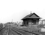
I did see that in an old picture of the station from the 60s or 70s on some website, that the crossing signal on one side of the tracks is far enough back to accomodate another track.

 #526967  by mainetrain
 
been wondering that too for years, thanks for bringing it up. Marty?

 #526982  by GOLDEN-ARM
 
Mods note: moved from Suzy forum to the LHR forum, for exposure.....

 #527033  by Paul Miller
 
The siding was originally for the creameries in the first half of the 1900's . Eventually, Valley Feed bought the property in the 1960's and used the siding for team track loading.

 #527311  by Marty Feldner
 
Yeah- like Paul said :-)

That was the Vernon team track, and I don't think it ever crossed the road. My guess is the rails are still there because they were too light (or old) to use for re-lay.

The current crossing was originally two tracks (hence the former crossing signal position). The current main, and a track between that and the passenger station, serving the station and the creamery across Vernon Crossing Road. That concrete foundation is the remains of the last of three creameries at that location. All three burned down, the last one in 1942.

If you don't have it, you might want to take a ride up to the Highland General Store, and pick up a copy of "Images of America: Vernon Township", by Ron Dupont (who also owns the store). (The Camera Haven store in your strip mall used to carry it also- don't know if they still do or not.)

 #527427  by nyswfan
 
What is that abandoned concrete structure?

I can only assume that the siding served that building.

 #527498  by Paul Miller
 
As Marty mentioned above, it's the foundation of the creamery.

 #527499  by Paul Miller
 
I have plenty of older shots in my book.

 #527502  by nyswfan
 
I have to modify my post from above about the concrete structure. I live in GGV, has anyone ever explored the Legends golf course grounds? There is a concrete structure next to the tracks, the golf course made it part of the sand trap at that hole. It appears as if the tracks were elevated at one time the way these cocrete supports are situated. Ill have to get down there and snap a pic of it....

 #527504  by Paul Miller
 
That's the remains of a coal trestle. The Bethlehem Quarry installed a power plant there across from its main works. The quarry is now also part of the golf course. The L&H delivered coal to the power plant.