OK, I just saw at http://www.bostonstreetcars.com/streetc ... oston.html" onclick="window.open(this.href);return false; a citation of 1909. However, it shows a photo of a car on this line in Stoneham in 1955, while others above say 1946 or 47 as an end date. Which one is it?
Railroad Forums
Old Rail Line Running Through Middlesex Fells Reservation
- Pertaining to all railroading subjects, past and present, in New England
Stoneham Line ended in 1946. The line from Sullivan to Elm Street lasted until 1955 under Boston Elevated and later MTA operation.
I've never been able to find a good, detail map of this line anywhere. I still don't know where it actually ended, once it left the Fells and went into Stoneham. I've read it went over to the zoo, and there may be some row evidence to support that, but I also read that it went up main street all the way to the stoneham branch where walgreens is now. The second option is what the maps i've seen tend to suggest, but they maps are so un-detailed that it's hard to judge based on them.
My YouTube Channel:
John's Train Videos
John's Train Videos

Streetcar Lines of the Hub has a nice map on page 142. It ran on Mystic Avenue out of Sullivan, on Fellsway and Fellsway West to around where 93 crosses over, then on a private right-of-way paralleling 28. At South Street, it joined Main Street and ran to Farm Hill station.

I had forgotten that one of the old bridges for that line is visible from Rt. 28, and therefore visible in Street View:
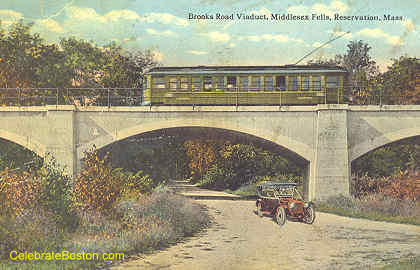
https://goo.gl/maps/W8TWyZ7TPLp Is the Brooks Road Viaduct still there??

It looks like the distance from it to Rt. 28 would be similar to the distance to the Sheepfold bridge...
https://goo.gl/maps/7D8QVe3QPzP2
but the old Brooks Road entrance is so overgrown you can't see anything from Street View:
https://goo.gl/maps/nxeiKcgdrmw
The only modern references to those bridges I could find are:
http://www.northshorenature.com/middlesex-fells-reservation/
https://goo.gl/maps/W8TWyZ7TPLp Is the Brooks Road Viaduct still there??
It looks like the distance from it to Rt. 28 would be similar to the distance to the Sheepfold bridge...
https://goo.gl/maps/7D8QVe3QPzP2
but the old Brooks Road entrance is so overgrown you can't see anything from Street View:
https://goo.gl/maps/nxeiKcgdrmw
The only modern references to those bridges I could find are:
http://www.northshorenature.com/middlesex-fells-reservation/
northshorenature.com wrote:The bridge which crosses above the Sheepsfold entrance is a former trolley bridge. Two other trolley bridges can be found in the Fells, one crossing Bear Hill Road and the other crossing a ravine west of Dark Hollow Pond.Was the Brooks Road Viaduct removed when I-93 was built?
The Blue Line is good for Lynn, and Lynn is good for the Blue Line.
My live MBTA real-time mapping apps:
https://sites.harvard.edu/~wuensch/T/subway-map.html
https://sites.harvard.edu/~wuensch/T/commuter-rail-map.html
My live MBTA real-time mapping apps:
https://sites.harvard.edu/~wuensch/T/subway-map.html
https://sites.harvard.edu/~wuensch/T/commuter-rail-map.html
There is not a single trace of that viaduct now. I assume it was removed for 93 construction. The right of way goes straight parallel to 28, then it just sort of ends, rolls down a hill to street level, into a large open space next to the highway and next to 28. You would never have known there was a train bridge there.
There are three still there. The one at the entrance to the shipfold that you linked to, another similar bridge deep in the woods, then the large trestle a little further along. In the winter (now) you can see half the trestle from 28 if you look in the right spot.
There are three still there. The one at the entrance to the shipfold that you linked to, another similar bridge deep in the woods, then the large trestle a little further along. In the winter (now) you can see half the trestle from 28 if you look in the right spot.
My YouTube Channel:
John's Train Videos
John's Train Videos
The Massachusetts state GIS group has the RoW in their rail layer as "GISDATA.TRAINS_ARC.4824", and it's viewable in their OLIVER tool.
I can't find a way to turn off the 3D trees in the web version of Google Earth, but if you use the real Earth app the other two bridges are really easy to spot because of the shadows they cast!!
This one is at 42.45744967538994,-71.1056615607615: ...and the other is at 42.45964876615285,-71.10439011309818:
The Blue Line is good for Lynn, and Lynn is good for the Blue Line.
My live MBTA real-time mapping apps:
https://sites.harvard.edu/~wuensch/T/subway-map.html
https://sites.harvard.edu/~wuensch/T/commuter-rail-map.html
My live MBTA real-time mapping apps:
https://sites.harvard.edu/~wuensch/T/subway-map.html
https://sites.harvard.edu/~wuensch/T/commuter-rail-map.html