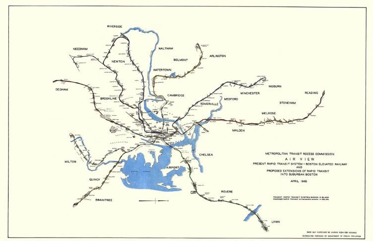
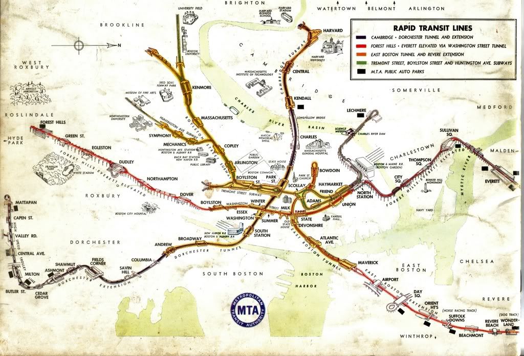
Well, here's a surprise, thanks to Leo Sullivan. This is a 1945 Metropolitan Transit Recess Commission (early MTA ?) map of proposed extensions of the rapid transit system. The Boston Elevated Railway Company was still running the system and the Metropolitan Transit Authority was two and four years away from taking over, legally and operationally, respectively. This is truely an amazing document as it shows the insight and vision that saw that this expansion might be possible, which in fact, actually did come to fruition decades later in many cases.
Of personal interest to myself was the fact that this map confirmed my earlier suspicions voiced on this forum, that it was my belief that plans had been made to extend southerly beyond Forest Hills on the Main Line. In fact, as I suggested, we can see that the tracks would have crossed the New Haven Railroad's Boston-Providence Main Line diagnolly, entering Roslindale Square and then running along the New Haven's Dedham Branch through West Roxbury into Dedham.
While Boston & Albany steam locomotives were hissing down the very same right-of-way, fourteen years before completion of the Highland Branch, they had it down precisely, with an added southerly jog into Needham Junction after Newton Highlands. Additionally, their Highland Branch connected with a loop that went through the Newtonville area, eventually entering the Pleasant Street Portal and entering the Central Subway System.
The Red Line goes to Arlington Heights via Watertown and Belmont, on it's west leg, and Braintree on it's east leg. Braintree would come to pass thirty-five years later !
In the news as I write this, a proposed extension beyond Lechmere goes not only through Somerville and Medford, but through Winchester as well, all the way to Woburn !
The northern leg of the Main Line goes way beyond it's current terminal area to Reading. It looks like the planners of 1945 envisioned the current Orange Line
plus, with either Everett maintained as a repair facility stub, or kept as a possible point of future expansion.
The East Boston/Revere Extension shows a ride along the old narrow gauge Boston, Revere Beach & Lynn right-of-way into Lynn, another proposed expansion as current today as back then.
I can't help but be in awe of the excellent system that this would have become, a system that appears to be at least double it's current size. Was this the MTA's vision of what was to come ? What here can you see as a "to be named" future extension ? It seems apparent that a good deal of construction making up this plan would be opposed on the grounds of "neighborhood blight" as well as other issues, but one can not help but to look at other larger systems and wonder why if it has been done elsewhere, it could not be done here. More subways than indicated, perhaps ? Well, anyway, if you see this map as the product of a big budgeted commissioned study twenty years from now, remember that the MTA did it in 1945 !
http://i203.photobucket.com/albums/aa26 ... TRCMap.jpg