Railroad Forums 

  • Meriden Branch, Waterbury

  • Discussion relating to the NH and its subsidiaries (NYW&B, Union Freight Railroad, Connecticut Company, steamship lines, etc.). up until its 1969 inclusion into the Penn Central merger. This forum is also for the discussion of efforts to preserve former New Haven equipment, artifacts and its history. You may also wish to visit www.nhrhta.org for more information.
Discussion relating to the NH and its subsidiaries (NYW&B, Union Freight Railroad, Connecticut Company, steamship lines, etc.). up until its 1969 inclusion into the Penn Central merger. This forum is also for the discussion of efforts to preserve former New Haven equipment, artifacts and its history. You may also wish to visit www.nhrhta.org for more information.
 #1376196  by YamaOfParadise
 
The intact segment of the line traversing that bridge is owned by the York Hill Quarry, kept for future use by them. It's also the namesake of Quarry Junction, since it was the only substantial purpose of the MW&CR outside of former industries in downtown Meriden.

Getting from the Springfield Line <-> Quarry Branch requires a direction reversal; certainly would be interesting to be moving heavy loads of stone from the quarry that way.
 #1376231  by Noel Weaver
 
I rode this trackage on a trip with one RDC set up by the late and great Ed. Kelly back in the mid 1950's, maybe 1956 or so. We used the connection at Quarry Junction and operated west to end of track at West Main Street then east as far as we could to Westfield.
Even at that time it was slow trackage but there was still business at both ends. More memories!!
Noel Weaver
 #1377265  by Engineer Spike
 
Before I84 got widened, it was easy to see parts of the line from the highway. I think that part of 84 was built on the rail bed.

One summer when I was in college, I was tending to my professor's house, while he was overseas for vacation. He lived in Prospect, close to Route 70. Somewhere near there there is a concrete railway arch bridge over a road. This is all near the four corners area where Wolcott, Prospect, Southington, and Cheshire meet. There was friend of Noel's and mine who took me on several abandoned rail line exploration trips. He said that a trolley line was also between Waterbury, and Cheshire. Does anyone know the area who knows the bridge described? Was it the steam line or trolley?

We also did the area near Westfield, where the Waterbury-Middletown line connected with Berlin-Middletown. What are the coordinates for Westfield?
 #1379568  by csor2010
 
Engineer Spike wrote:Does anyone know the area who knows the bridge described? Was it the steam line or trolley?
It was probably the trolley given the construction of the remaining bridges on the line. My understanding of the MW&CR is that it was built with many wooden trestles and few substantial structures. I'm guessing the one you saw is this one. This is a concrete arch but has stone facing applied; to my knowledge it is still there today. There were one or two others as well, but based on the old aerials they were gone as soon as the line closed.
We also did the area near Westfield, where the Waterbury-Middletown line connected with Berlin-Middletown. What are the coordinates for Westfield?
Approximately here, at 41.5997N 72.6953W.
 #1379643  by Allen Hazen
 
Brings back a memory. I ***think*** I found traces of the right of way of that same interurban trolley line back in the early 1970s. The Canal Line track crossed West Main Street, Cheshire (= Rt 68, I think) near the bottom of the hill a few hundred yards west of the center of Cheshire village. Walking up the C.L. right of way North from the road crossing I found-- perhaps a hundred yards north of West Main-- what looked very much like a railway embankment, much overgrown and with no visible traces of actual track. My guess is that at that point the trolley line was more or less parallel to West Main Street (so: roughly East-West), and that the trolley track went over the Canal Line track on a long-since disappeared wooden trestle.
 #1380995  by FLRailFan1
 
TomNelligan wrote:
Jeff Smith wrote:I believe there is a bridge remaining of this branch over the Hartford line. I think it was known as the Meriden, Waterbury & Connecticut River RR.
Yes, the bridge is still there at what the NH used to call Quarry Junction, along with some intact but extremely overgrown trackage (not used since the 1970s) that extended a couple miles to a quarry east of Meriden. That remnant crosses under the limited access stub of the Berlin Turnpike not far north of the I-691/I-91 junction, and it's visible from the highway overpass in the winter when there are no leaves.
There's also a rail trail crossing 691 not far from Meriden;
That's the former NH Canal Line, not the MW&CR.
If I'm not mistaken, the old MC&CR line in Meriden is intact because of the quarry.
 #1381042  by YamaOfParadise
 
FLRailFan1 wrote:If I'm not mistaken, the old MC&CR line in Meriden is intact because of the quarry.
Yes; they bought it from either the PC (or NH, leaning towards PC) to preserve it in case they ever wanted to ship by rail again.

And while from your earlier posts I can tell you know, but "intact" is a very gracious term to use... I'd say at least half of the line is completely untraversable even by foot. The swamp immediately west of the quarry has largely subsumed the RoW, and most of the forested segments are dense with brush and trees.

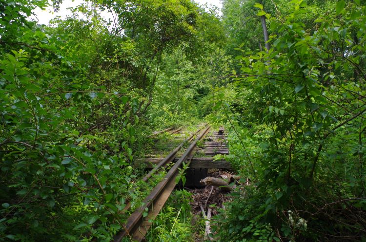
And speaking of the line being built of mostly wooden trestles as opposed to solid figures, one such of these structures is immediately east of the Wilbur Cross Parkway overpass, which is itself right next to the park at Baldwin Pond. Took this photo last summer... gives a pretty good idea of what kind of state the line is in.
Image
I've considered trying to walk the portion east of North Wall Street, towards the junction with the Center Street Branch (which from State ownership map York Hill also owns), where there should be a wooden trestle there at the junction, and to see what lies on the Meriden branch east of there. But I'm convinced you'd need a brush cutting tool to really be able to traverse it (at least starting from North Wall Street), and that's just for feasibility: it's still trespassing. And while I don't imagine York Hill particularly cares, it still looks mighty suspicious to the people's properties you'd be passing by (and who would probably consider it passing through), especially in a less-than-safe place like Meriden... which is also another point, is that the closer you get to Quarry Jct, the more dangerous it would (probably) be by virtue of the places you're around.

A small question I thought of writing this post, when was the last time the Center Street Branch was used? (Asking here since it's more of a spur of the Meriden Branch then a branch unto itself.) It has an underpass underneath I-691, so it had to be at least in the 60's; what was then built as part of a CT-66 freeway was built west of US-5 between 1966 and 1971.