the road bed is there at happy valley campground. you have to follow the nature trail to get to it. At one end of the roadbed it runs into a farmers pasture with a fence! At that fence is a partial of a bridge (no timbers, just cut stone). The other end is as clear as could be! But then it drops off like no tomarrow! you can follow it fo a while, but its very grown up! 
Railroad Forums
Unfinished Railroads of New York State
- Pertaining to all railroading subjects, past and present, in New York State.
Moderator: Otto Vondrak
Sounds like I need to get down there with a GPS receiver! It's only about two hours from my house.

yeah its been awhile since Ive been there. If I remember correctly they had one of those historical markers next to it. i wish that map finder was alittle better so i can figure where its at. Im going to look more into it here on the net. Good luck and let me know how u make out
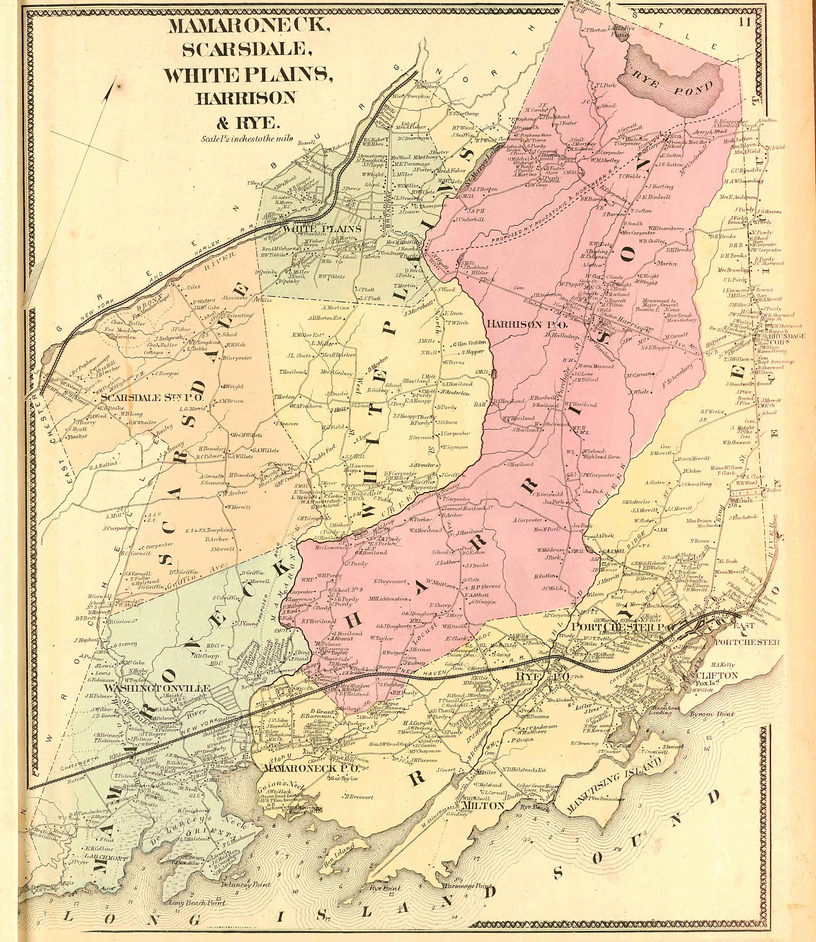
I didn't see the N.Y. Housatonic & Northern on your list -- or did I just miss it? This reportedly had graded 23 miles of a route between White Plains, NY and Danbury, CT. I understand some of this grading is in Westchester County north of White Plains. There was also a Southern Westchester, which was to extend the NYH&N south from White Plains to the Harlem River, and supposedly also did grading -- but nobody seems to know where.
there is 30 miles of track were former conrail went south heading to east river road in rush.
conrail6479 wrote:there is 30 miles of track were former conrail went south heading to east river road in rush.If track was laid I don't count it as unfinished. I guess that somewhere is a railroad on which they laid track but never ran an engine over it. I'd include that.
BaltOhio wrote:I didn't see the N.Y. Housatonic & Northern on your list -- or did I just miss it? This reportedly had graded 23 miles of a route between White Plains, NY and Danbury, CT. I understand some of this grading is in Westchester County north of White Plains.Any idea where it is? Any pointer to more information?
There was also a Southern Westchester, which was to extend the NYH&N south from White Plains to the Harlem River, and supposedly also did grading -- but nobody seems to know where.Yeah, it's harder to track down information on unfinished railroads.
RussNelson wrote:RussNelson. what i'm talking about is the old EL line. CSX recycling plant near Kodiack plant. That goes from the recycling plant and ends on the switch LA&L and it's CSX track but they don't run any trains on that track. This is near NYMT building.conrail6479 wrote:there is 30 miles of track were former conrail went south heading to east river road in rush.If track was laid I don't count it as unfinished. I guess that somewhere is a railroad on which they laid track but never ran an engine over it. I'd include that.
The NY, Housatonic and Northern did some work in Westchester and the Northwest corner of Greenwich CT. This work was mostly done in 1867-1868. Old maps of North Castle (NY) and Greenwich show the proposed route. You can still see the work today.
I was in the Chappaqua Library a week ago and looked at North Castle history. There was a picture of the Housatonic grading that had been done in Greenwich on Sterling Rd. (still a private road) I do not know why the company was working in the middle of the proposed line in CT, but it may have had something to do with preserving their CT charter.
If you do a Google map search for 760 Riversville RD and go to the "hybrid" map, you will see the remnants of the roadbed work to the west of Riversville Rd. This grading continues to Bedford Rd in Greenwich. (Part of the original Post Road from NYC to Bedford and north. What you see on the map is a fill and can be clearly seen today.
The line was to enter CT just north of the Westchester County Airport, cross Bedford Rd, Riversville Rd, Sterling Rd and then re-enter North Castle at Creemer Rd, just inside the NY State line. I believe this was to be the location of the Armonk Station. I do not know if a station was planned for North Greenwich.
Parts of the work were obliterated by the Tamarack Country Club.
Try this link. Click on the link then select JPEG. Then go click the upper left of the map to see the proposed route. You can click to enlarge for better detail.
http://magic.lib.uconn.edu/cgi-bin/MAGI ... s32.unkn.1
There is an 1868 North Castle map that shows the sections on either side of Greenwich. I have the map but will try to find a link.
Here is a link to the North Castle map from 1868. This shows the route of the NY, Housatonic and Northern:
http://www.davidrumsey.com/maps1557.html
Here is a link to the Bedford map from 1868. This is a somewhat different route than the NYW&B planned to take to Bedford some 50 years later. The NYW&B station was planned for Pound Ridge Rd. east of the center of Bedford. The NYW&B actually purchased land for that purpose and this is shown on maps of Bedford from the 1920s.
http://www.davidrumsey.com/maps1549.html
Here is a link to the Google map showing what remains of the grading in the north west corner of Greenwich just west of Riversville Rd:
(you have to click hybrid)
http://www.google.com/maps?q=760+Rivers ... p&ct=title
s4ny wrote:If you do a Google map search for 760 Riversville RD and go to the "hybrid" map, you will see the remnants of the roadbed work to the west of Riversville Rd. This grading continues to Bedford Rd in Greenwich.SPECULATION: Continue the lline of that grading past Bedford Rd. down to Cutler Rd.:
http://www.google.com/maps/ms?ie=UTF8&h ... 5186750fda
Do you think it might have gone that far?
Are there any remains beyond what I've drawn above?
Russ, e-mail me off-list. I have maps for the NYH&N and WN that may be of help to you.
-otto-
-otto-
----------------------------------------------
Moderator: New York State Railfan :: New York Central :: Toy Trains
NYW&B Fan Site :: A Magazine I Read Often :: A Museum I Volunteer At
Moderator: New York State Railfan :: New York Central :: Toy Trains
NYW&B Fan Site :: A Magazine I Read Often :: A Museum I Volunteer At

Re the Google Map from Russ: I think that is a continuation of the roadbed work.
This map shows the proposed line from White Plains to the CT state line.
http://www.westchesterarchives.com/CW/i ... resize.jpg
You can see the proposed line just south of the old Rye Lake. Purchase St. at its intersection with Old Lake St. may have been moved. The Friends Meeting House is still there, but may have been moved also because of either the expansion of Rye Lake for the Kensico Dam or the Westchester County Airport.
The Atlantic & Great Western graded and installed stone masonary work in Chautaugua Co.NY,never saw track laid.I do not know what town or towns it ran thru. I believe the route would have brought it thru Catt. Co. across Catt. Creek into Erie Co. West of Springville and north to Buffalo.
Bob
Bob
s4ny wrote:You can see the proposed line just south of the old Rye Lake.Are you sure that isn't the NYWB?
http://rutlandtrail.org/gmap.cgi?nywb-e ... n.ny.track