Hello,
Im new here, have been searching quite a bit on somthing I find very interesting, the Carlton Hill Station on the Erie Main Line.
Im very familiar with the Rutherford train station. Ive been pulling down all the old maps I could grab from Wikipedia, etc., trying to fully understand the way the rails used to go and got aligned.
See, my familiarity has always been that the train came from Hoboken (I get that from Rutherford it originally went to Jersey City, but changed to Hoboken after the E-L merger), and then just past the station, curved and went off towards Suffern. These days that is known as the Bergen County Line.
There was always a curiosity in my mind, which I only learned enough about over the last few days, as to why though NJT curved off, there was a rail line (that sometimes saw freight) that stayed straight and ended at the Passaic River.
I get it, kind of. This was the Erie Main line originally. It went off to Passaic, then Paterson, Ridgewood, onward.
The original D,L&W line is what NJT also calls the "main line", but it was the DLW main line.
So the main line and Bergen line services now on NJT are really a combination of what was the Erie Main line and the DLW main line, right?
But what Im failing to see is the way things were before all the alignments.
If I assume that this NJT map is geographically accurate:
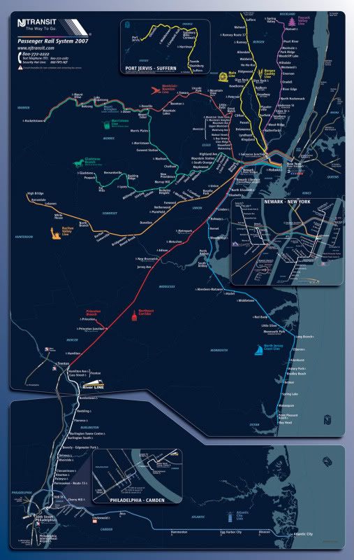
then my take away is that the ORIGINAL Erie railroad would be drawn if one was to essentially straight-line connect from Jersey City through Patterson (which actually connects through Rutherford and falls straight along the trackage that NJT shows from just past the curves by seacaucus junction to the curve just past Rutherford.
So it would look like this:
Is that accurate?
The thing that confuses me though, is the description from Wiki on Carlton Hill. "After the merge on October 17, 1960, between the Delaware, Lackawanna and Western and the Erie, the city officials in Passaic once again brought back the possibility of removing the tracks through Main Street, Passaic. This time, the newly formed Erie–Lackawanna went forward with it, beginning the process to move its main line onto the former Boonton Branch and Newark Branch through Lyndhurst, Passaic and Clifton."
http://en.wikipedia.org/wiki/Carlton_Hi ... station%29
However, if we look at maps of the Erie and the DLW railroads, it appears to me that the Boonton Branch was actually the DLW main line that went through Kingston, Lyndhurst, etc.
But this conflicts. The train line that goes through Rutherford is the Bergen line, not the DLW Main Line that would have gone through Lyndhurst and Boonton.
So what am I missing? It seems to me that:
At some point, Erie lines were shifted from Jersey City to Hoboken, OK, I get that.
Carlton Hill Station was EOTL when the lines through Passaic got shut down.
Rutherford station was always a station stop regardless of track alignment at the Passaic River.
So, that said, was the "curve" in the track that aligns the Erie Railroad through Rutherford as it is currently shown on the NJT maps (Through Garfield to Glen Rock, before going on to Suffern) put in after the closure of the Passaic River bridge, which forced Carlton hill to be end of the line?
Or was there yet another line that always split in Rutherford, past station square, which was an alternate to the Erie Main Line that passed through Passaic? That is the intent of this long-winded first post, to understand what the Erie stations truly were (tough to grasp off of Wiki), and how they were set up through Rutherford, given that the Erie Main Line always went up to Suffern, and the claims of Wiki that traffic was diverted to the Boonton line could not be accurate, since that was a different DLW line that still to this day has distinct trackage that DOES NOT go through Rutherford Station.
Phew. Hope that is understandable. Would love to hear any insight that anyone might have. I hope to grab some pictures of what is left of the Carlton Hill Station ruins this weekend.
Thanks!
Im new here, have been searching quite a bit on somthing I find very interesting, the Carlton Hill Station on the Erie Main Line.
Im very familiar with the Rutherford train station. Ive been pulling down all the old maps I could grab from Wikipedia, etc., trying to fully understand the way the rails used to go and got aligned.
See, my familiarity has always been that the train came from Hoboken (I get that from Rutherford it originally went to Jersey City, but changed to Hoboken after the E-L merger), and then just past the station, curved and went off towards Suffern. These days that is known as the Bergen County Line.
There was always a curiosity in my mind, which I only learned enough about over the last few days, as to why though NJT curved off, there was a rail line (that sometimes saw freight) that stayed straight and ended at the Passaic River.
I get it, kind of. This was the Erie Main line originally. It went off to Passaic, then Paterson, Ridgewood, onward.
The original D,L&W line is what NJT also calls the "main line", but it was the DLW main line.
So the main line and Bergen line services now on NJT are really a combination of what was the Erie Main line and the DLW main line, right?
But what Im failing to see is the way things were before all the alignments.
If I assume that this NJT map is geographically accurate:
then my take away is that the ORIGINAL Erie railroad would be drawn if one was to essentially straight-line connect from Jersey City through Patterson (which actually connects through Rutherford and falls straight along the trackage that NJT shows from just past the curves by seacaucus junction to the curve just past Rutherford.
So it would look like this:
Is that accurate?
The thing that confuses me though, is the description from Wiki on Carlton Hill. "After the merge on October 17, 1960, between the Delaware, Lackawanna and Western and the Erie, the city officials in Passaic once again brought back the possibility of removing the tracks through Main Street, Passaic. This time, the newly formed Erie–Lackawanna went forward with it, beginning the process to move its main line onto the former Boonton Branch and Newark Branch through Lyndhurst, Passaic and Clifton."
http://en.wikipedia.org/wiki/Carlton_Hi ... station%29
However, if we look at maps of the Erie and the DLW railroads, it appears to me that the Boonton Branch was actually the DLW main line that went through Kingston, Lyndhurst, etc.
But this conflicts. The train line that goes through Rutherford is the Bergen line, not the DLW Main Line that would have gone through Lyndhurst and Boonton.
So what am I missing? It seems to me that:
At some point, Erie lines were shifted from Jersey City to Hoboken, OK, I get that.
Carlton Hill Station was EOTL when the lines through Passaic got shut down.
Rutherford station was always a station stop regardless of track alignment at the Passaic River.
So, that said, was the "curve" in the track that aligns the Erie Railroad through Rutherford as it is currently shown on the NJT maps (Through Garfield to Glen Rock, before going on to Suffern) put in after the closure of the Passaic River bridge, which forced Carlton hill to be end of the line?
Or was there yet another line that always split in Rutherford, past station square, which was an alternate to the Erie Main Line that passed through Passaic? That is the intent of this long-winded first post, to understand what the Erie stations truly were (tough to grasp off of Wiki), and how they were set up through Rutherford, given that the Erie Main Line always went up to Suffern, and the claims of Wiki that traffic was diverted to the Boonton line could not be accurate, since that was a different DLW line that still to this day has distinct trackage that DOES NOT go through Rutherford Station.
Phew. Hope that is understandable. Would love to hear any insight that anyone might have. I hope to grab some pictures of what is left of the Carlton Hill Station ruins this weekend.
Thanks!