• The Get Philly Moving Plan

  • Discussion relating to Southeastern Pennsylvania Transportation Authority (Philadelphia Metro Area). Official web site can be found here: www.septa.com. Also including discussion related to the PATCO Speedline rapid transit operated by Delaware River Port Authority. Official web site can be found here: http://www.ridepatco.org/.
Discussion relating to Southeastern Pennsylvania Transportation Authority (Philadelphia Metro Area). Official web site can be found here: www.septa.com. Also including discussion related to the PATCO Speedline rapid transit operated by Delaware River Port Authority. Official web site can be found here: http://www.ridepatco.org/.

Moderator: AlexC

  by Phil O.
 
Hello All,

I've been browsing here for a little while, but this is my first post. I also thought it would be one of the best places to get feedback on a personal project I've been working on - The Get Philly Moving Plan.

Some of you may be familiar with Damien Goodmon's "Get L.A. Moving" Plan (which can be seen at http://glam.fminus.com/). I've studied it in the past and thought that Philly could equally benefit from a system that strong.

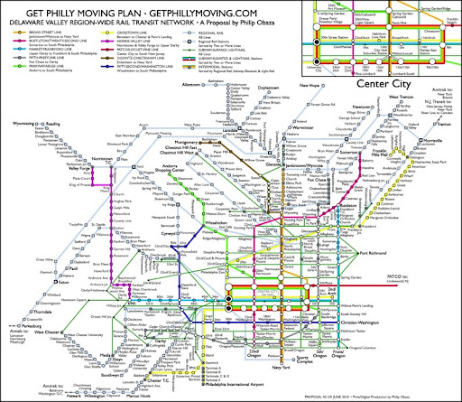
Below is the map I've come up with for the plan. It combines several previously proposed extensions, some speculated on various message boards, and of course, my own contributions. The colored lines are intended as subway/elevated heavy rail lines, the smaller green lines are trolleys, and the rest is commuter rail. I'm working on getting it copyrighted so that I may turn the proposal into a website, but any feedback or suggestions you guys might have would be greatly appreciated, as it's still a document in some transition. Thanks!

Higher-res version here - http://lh5.ggpht.com/_nFTM3QfQ1LM/TBC7c ... Moving.jpg

Image
  by scotty269
 
Whoa there, buddy. Thats, uhh, ambitious...
  by theWatusi
 
Nice work.
  by Thomas K. McHugh
 
Now that's what I call "CONNECTIONS!"

You need to send this to DVRPC tomorrow!

Makes me kind of sad that SEPTA has eliminated 64 commuter rail stations in the last 32 years.

Well, the way I see it, if the U.S. wants to remain a superpower, this is closer to what our future needs to be than the present system.
  by Chtorr00
 
I think you have moved beyond fantasy map to wet dream map. :P

More constructively, your map could really use PATCO extended to Atco, the new line down to Glassboro/Vineland, and the River Line (extended to the NJ Capital district).
  by MikeBPRR
 
Wow...um, want to make a Google map of this so I can actually get a sense of where things are when where things go?
  by tgolanos
 
Is the area around Center City/Suburban Station supposed to be a ring-system of some kind or am I just reading it wrong?
  by R3 Passenger
 
O.o

Wow. Just......wow.

Anyone got a trillion dollars floating around somewhere?
  by MelroseMatt
 
Fascinating. I love exercises like this. I've worked on a few uh, less ambitious plans (http://www.flickr.com/photos/12097616@N08/sets/) and have more floating in my head waiting for a chance to put on pixels.

One thing that's missing, the project that was actually started, the Roosevelt Blvd extension of the Broad St. Subway. It looks like you try to end transit lines at interchanges with other lines, to create a better interconnected web - I like that. I figured the Roosevelt Blvd. El should split, and one branch head past Franklin MIlls to end at Cornwallis Heights, and the other branch parallel Byberry Rd. on the unused Woodhaven Expressway right of way to interchange with the R3 (West Trenton Line to be P.C.) at Forest Hills or Somerton.

Of course I'm looking in my backyard too. It looks like the intent for the Broad St. Subway extension up PA-611 Old York Rd. is to continue to Township Line, and then head west to the Jenkintown Train station. Elkins Park station is actually two blocks off of York Rd. so you're intermodel station would involve a long walkway I suppose. The old Chelten Hills Station is still there, now home of the Chelten Hills Model Railroad Club.

And the south end of the BSS should tunnel under the river, one due south, landing in National Park, and one due east, landing in Gloucester City. These can extend a ways into NJ as well.

Make sure you indicate the West Trenton line continuing to Hoboken and New York. And why not an Atlantic City line, continuing south to Cape May?

If nothing else, a map this ambitious will get conversations started. Maybe the city will lose some of the fear of growing upwards, to increase the density, to put rapid transit lines to good use.

And I hope we can use some all new R numbers. Maybe S numbers for the subways and T numbers for trolleys as well.
  by ChrisinAbington
 
R3, you talking the capital or operating costs? ha-ha-ha..
That would be quite the system for a city of 10-15 million.
I was also really hoping to see a high speed connection to the cold fusion powered space elevator that I'll build in my backyard about the same time (using the same funds.)
Oh well, the map is certainly creative and must have taken some time to put together. Good work considering the wide range of bizarre ideas.
  by Tritransit Area
 
I like it! It is quite awe inspiring. One could only imagine what things would be like if we actually had such a system in operation!

The Get [city] Moving plan seems like a very interesting idea. If people agree on a priority listing, hopefully we can get some of the projects built to enhance transportation in the region.
  by Chtorr00
 
Another obvious addition is the Phoenixville-Paoli Greenline.
http://en.wikipedia.org/wiki/Greenline_(Pennsylvania)

One way to make the map more effective would be to show the phasing and evolution of the new lines. You could do versions for 2025, 2050, 2075, and use the completed plan for 2100.
  by Thomas K. McHugh
 
I still remember the old number six trolley running through Glensde and Abington to Willow Grove.
  by tgolanos
 
MelroseMatt wrote:And I hope we can use some all new R numbers. Maybe S numbers for the subways and T numbers for trolleys as well.
I got somthing like this 'worked out' in my own fanatasy map. If you want to see it, I have it in PowerPoint- I can email it to you. Send me a PM if you're interested.
  by JeffK
 
ChrisinAbington wrote:That would be quite the system for a city of 10-15 million.
Berlin (3.3 million, urban zone) and Paris (2.2 million) aren't in that league population-wise but their rail coverage is closer to what's on this map than what currently exists in Philadelphia. Also these services cover a much larger metro population - e.g. Paris' is around 11 million and Philly's is about 5.7 million. Even cutting in half what's on that (very ambitious) map what we currently have doesn't come close.

Berlin U-bahn/S-bahn map: http://www.visitberlin.de/bilder/verkeh ... _08.08.PDF
Berlin Strassenbahn map: http://www.visitberlin.de/bilder/verkeh ... hnnetz.pdf
Paris Métro/RER map: http://www.ratp.info/orienter/f_plan.ph ... aux&fm=pdf