• Historical Maps of Connecticut Railroads and Trolleys

  • Pertaining to all railroading subjects, past and present, in New England
Pertaining to all railroading subjects, past and present, in New England

Moderators: MEC407, NHN503

  by RichCoffey
 
A compilation of Connecticut historical railroad and trolley maps. Thumbnail navigation provides easy visual access to a variety of online maps and historical info.
http://www.vizettes.com/kt/ct-rr-maps/index.htm

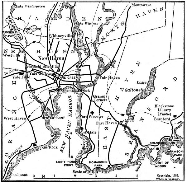
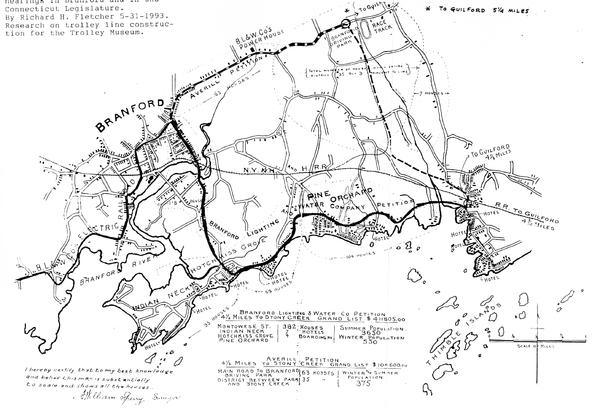
It is by no means complete but a good start. If anyone has links to any additional CT historical maps in this black & white design style (EXAMPLE > http://www.kinglyheirs.com/CNE/CNEphoto ... aximum.jpg), I will update the page accordingly.
(PLEASE NOTE: This request is specific to Connecticut Railroads only)
  by jaymac
 
Thanks -- I think -- for a new addiction! Just plug in different states and remember to eat!
  by The EGE
 
jaymac wrote:Thanks -- I think -- for a new addiction! Just plug in different states and remember to eat!
No problem! I'm slowly adding more to the New England categories as I find them.
  by Ridgefielder
 
shepaug wrote:hey....the Shepaug went south to Bethel 'station' area ?? not Danbury ??

http://www.vizettes.com/kt/ct-rr-maps/m ... ug-map.jpg" onclick="window.open(this.href);return false;
Depends on when you're talking about. The Danbury & Norwalk built a branch from Bethel to Hawleyville in 1872, and the Shepaug ran at least their passenger trains through to Bethel. The Hawleyville branch was abandoned in 1911 by the New Haven (I think the first abandonment in the State of Connecticut) and after that trains terminated in Danbury.
  by RichCoffey
 
Yes that IS confusing - I just emphasized the Shepaug ROW on the old map

but it was actually D&N tracks
http://en.wikipedia.org/wiki/Danbury_an ... k_Railroad
"In Spring 1872 a branch between Bethel and Hawleyville was started. It allowed for connections with the Shepaug Valley Railroad, Housatonic Railroad, and eventually the Boston, Hartford and Erie Railroad once it was completed through Hawleyville. There were plans in which the D&N would be a link in a railroad connecting New York and Boston, but these died with LeGrand Lockwood, the nephew and financial backer of Edwin Lockwood, in 1872."

When I get a moment I will add some notation on the graphic to indicate that - errors in posted History are unforgivable!! :-)

Thanks for pointing that out
  by YamaOfParadise
 
One of the projects in my OpenStreetMap endeavors has been adding data on the New Haven's street railway lines, since in most cases the RoW's remain perfectly intact, and therefore mapping them provides good historical context. As such, I've looked somewhat extensively for anything that'd help that. Not all of these fit the guidelines of black-and-white and the system map style, but they're still worth posting. The Price and Lee Co. ones are interesting because they also show the progression of bustitution, and the right of ways. All the stuff from the Connecticut History Online is not public domain, but as long as you give proper attribution per their guidelines, you'll be able to put it on the site itself.

System Maps: Price and Lee Co. City Maps: Various Valuation maps: That's all I know off the top of my head for street railways. I've been meaning to go up to UCONN's Main Storrs campus at some point to look through the archives to see what's there - especially since most of the content of their collections is only summarized online. I'm sure that the collections that BERA and CERA maintain probably have good stuff in them as well.

I'll make another post soon with what I have for heavy rail.
  by RichCoffey
 
Ridgefielder
Yes this other map confirms the Hawleyville Branch as well
http://www.vizettes.com/kt/ct-rr-maps/ct-1893.htm
I have updated the Shepaug map accordingly - I hope this is accurate now :-)

++++++++++
YamaOfParadise
Ages ago when I built the New Canaan Branch Line site - I reached out to Laura Katz Smith at UConn for permission to use photos and suggested guidance. She was very helpful. See credit at bottom of page
http://www.vizettes.com/ncrr/whatsnew.htm
If she is still there, I recommended you look her up, etc.

I will add your links at a later date - thank you - If you are building any kind of web page mini site regarding CT trolleys and the work you are doing, let me know and I will just include that URL instead. BTW That's Great work you are doing !
  by RichCoffey
 
Shepaug, Litchfield and Northern Railroad
Hawleyville to Bethel (from the UNH historical Topos)
Image

I will trek this soon...
  by RussNelson
 
YamaOfParadise wrote:One of the projects in my OpenStreetMap endeavors ....
Yay! I found a database in NY of railroad crossings. I've got a thingie that examines them one at a time into JOSM and loads a small box around them. Then I can see if it needs marking as a railway=level_crossing, or if there is a proper bridge there, or whatever else needs fixing.
  by Leo Sullivan
 
I think the valuation map that was posted was a sort of index map and there
are divisional maps too. I know there are for the Massachusetts "Consolidated"
lines (and other companies too). Does UConn have them?
Conn. Co had their own track maps too (see enclosure)