by SbooX
(Sorry this is so long. Its an idea I've been thinking about for a while now, so it requires a lot of..... words.)
The Green Line is in sad shape. It carries 204,800 people on an average day (FY '04) on what is basically a glorified nineteenth-century trolley line. Though the transit world has seen countless improvements in the century since the opening of the Tremont Street Subway, the Green Line has seen few of those advances. The LRV's that serve the line today are arguably just bigger streetcars. The signaling system offers only a slight improvement in safety and efficiency over the ones in place at the turn of the century. And the capacity and speed of the system is severely limited by the small size of LRV's, awkward boardings, bunching of trains, and stops in much too close proximity to each other (at least on the surface).
So what to do? The T says that upgrading the signals, while improving safety, would also decrease system capacity. The T also says that they can not run any more trains through the Central Subway. Adding a third car to all train sets would help somewhat, but only at a huge extra cost of personnel and maintenance, and it would still have the awkward boardings which slow trips.
Seems like we're in a bad spot. So I propose throwing the whole thing out.
Too many people are served by the Green Line to keep it as a light rail system. We need to stop kidding ourselves about this. It serves (almost) as many people as the Red Line, which is heavy rail with large six-car train sets. The time has come to convert the Green Line to heavy rail.
Already I can hear the screams coming.
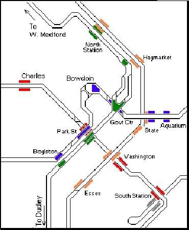
The tunnels are too tight for heavy rail! Yes, in some spots. Mostly (in my entirely unscientific reasoning) the problems would be between Haymarket and Arlington. It would require some very big changes in a few areas. The one big sticking point seems to be the turn at Boylston station. Well, why not just adjust the tunnel trajectory in such a way that the curve is less extreme? It seems to me that it should be very possible to tunnel under the Boston Common and make the turn a little more friendly (and less screech inducing).
Now heres another way to make it easier to fit heavy rail into those tunnels. Use Blue Line sized cars. Those puppies were already designed for tight turns, since they have to operate in a former streetcar tunnel (sound familiar?) and along an old narrow gauge railroad. Sure, they won't be able to make the Boylston curve, but they will be fine at many other places where Red Line or even Orange Line equipment would have serious trouble. The Green and Blue Line could even share equipment, maintenance facilities, personnel, and track.
Excuse me? Share track? Yeah, why not? I would propose building a new incline at/near Government Center and Park Street. At this incline the Blue Line would join the Green Line tracks and continue past Government Center to Park Street and beyond! Other cities have major heavy rail lines share track, heck we even do it with the Red Line branches. I think it could be done.
It would likely necessitate large train sets. I'm talking 8-12 cars for peak service. New stations should be built to accommodate at least 10 cars. My own (again, unscientific) estimations put rush hour headways at approximately 6 minutes per branch, 3 minutes for the shared sections.
Oh yeah, what about the branches? How would you handle that? A good question, and probably the one that will tick off the most people. I am proposing a two branch system that would replace the existing Blue and Green Lines. I would actually propose keeping the existing coloring scheme, though modified of course.
The Blue Line would stretch from Lynn (or Wonderland or Salem or Beverly or Maine or whatever it takes to make you feel all warm and tingly) to Government Center, meet up with the existing Green Line ROW to Park Street all the way down to Kenmore. From Kenmore it would surface and go west following the existing Riverside “D Line” ROW, making most (but probably not all) of the existing stops along the way.
The Green Line would stretch from West Medford (or Lechmere or Union Square or Vermont, again whatever makes you feel good) following the current Green Line alignment to Kenmore Square. At Kenmore, it would continue on in a new tunnel under Commonwealth Avenue to at least Packards Corner. After that point, it gets a little more tricky. Although I would really like to continue on in a tunnel under Comm Ave all the way to Boston College, I suspect that the costs would be much too prohibitive. One alternative I've thought about is a mostly surface running, grade separated ROW in the existing B Line ROW. Grade crossings would be closed, or the tracks could be elevated or tunneled over the roadway. Under no circumstances would I support the die hard rail fans wet dream of an elevated structure over Comm Ave. It would seem prudent however, to use a viaduct or tunnels in some places. Another (more cost effective?) option might be to give these bad boys pantograph's and let them have a limited number of grade crossings. Most crossings would still be closed however. Also note, that I would not support having third rail power along with grade crossings as is apparently done in Chicago (and shown in a recent thread here). Something tells me the residents would agree.
I've barely touched on construction at this point. As I mentioned, some tunnels would have to be reconstructed. But there is also the need for third rail installation (most likely), new signals, possibly new track, and new platforms. Its the later that will be the most difficult. Simply put, I don't have an easy answer for building new platforms, but I'll throw out a few ideas.
Alright, lets start with the basics for upgrading the existing Central Subway stations. Given that my plan would use 8-12 car trains, and given how close together many of the stations are, I figure we could sacrifice a few stations. Keeping the biggies, like Park and North Station are givens. Theoretically we could do away with Haymarket (redundant to have two transfer points to the Orange Line) and Government Center (redundant since Blue and Green now meet @ Park), though I'm not sure if we should give them up since it will reduce crowding from other stations. Its worth thinking about to save costs though. These stations could be consolidated: Boylston/Arlington, Copley/Hines.
There are a few benefits to consolidation. Obviously, travel time will be decreased. Also, since the new stations would be so much larger there would be less walking distance between them. And heres the big one. If we only build a few stations in between existing stations, it will simplify construction, reducing costs, and... allow existing Green Line service to continue (mostly) uninterrupted. I think so anyways.
Another option would be something akin to how New York rebuilds its stations. Shutdown one side of the station so that service is available only in one direction. If someone wants to go the other direction, they ride the train 1-2 stops the wrong way and switch sides. Not sure if this is the best idea. Very unsure when you start talking about consolidating stops.
A third and (significantly) crazier idea is to lay temporary tracks on the streets of Boston. Man wouldn't that be fun? Shutdown Tremont & Boylston Streets and there you go. Don't think this would go over too well with the public, not to mention it would be slow, quite possibly the most expensive way to do it, and wasteful since the tracks would be pulled up at the end of construction. Plus theres the ADA to consider.
As for along the existing B & D lines, well it would be easier. For one thing you could bustitute the lines during construction if necessary. (I know, booooooooo!) Obviously, you are going to do massive consolidation along the B line. In places, 3-4 stops could easily be reduced to just 1. (I'm looking at you Blandford, BU East & BU Central!) Most of the D line stops would stay, though we could probably spare a few. And yes, all the stops would have Charlie card gates.
Hmmmm... I feel like I'm forgetting some tiny little detail... Oh right! The C & E lines! How silly of me. Well, sorry to say, they don't warrant upgrading to heavy rail. So, we've got two options. Either keep them as light rail lines, but don't run them all the way to downtown, or bustitute them. Yeah, that last option doesn't sit too well with me either.
So lets keep em as LRT, and in mainly the same shape they are in right now. We could do the simple thing and keep them terminating at Kenmore and Copley, but what fun is that? Lets do something fancy.
Start at the E Line southern end (Heath, Arborway/Forest Hill, Providence RI, whatever). Follow that up into its existing portal at Northeaster. Once underground, take a left turn under Massachusetts Ave to Comm Ave, then tunnel under Comm Ave to Kenmore Sq station and out through the existing St. Mary's portal to Cleveland Circle. You could build a new station near Berkley. With some clever engineering, you might be able to rebuild Kenmore in such a way as to allow cross platform transfers to the Green and Blue lines like the North Station “Super station.” At the very least you could make it a simple flight of stairs/escalator. And feel free to give this line a color if you like. Might I suggest, teal, a combination of blue and green?
The new Mass Ave tunnel could even have the tracks paved over so that buses could use the tunnel as well. Well, with a few new portals at least. Maybe it could eventually serve as a tunnel for a LRT service to replace the #1 bus. (Urban Ring?)
Heres an idea to further enhance the new service. Give the new Green and Blue lines (former B&D) short tunnels, that would take them out to the vicinity of Cleveland Circle. From an underground station there, riders could transfer to the “Teal Line” and “Teal Line” riders could also connect to the Blue and Green. More interestingly, Blue and Green riders could connect way out in Brookline, further reducing the radial nature of the T as it currently is. Excluding the proposed Urban Ring, it would be the only MBTA subway-subway transfer in suburbia.
So, sounds simple right? I mean if we live in a city that can get the Big Dig done on time and under budget, this should be easy as pie... crap...
But seriously, am I way off base here? I welcome all critiques and honest criticisms, except those of the ”OMG LOL THIS W1L NEVAR HAPIN!!!!!!!!!!!!!!!!!1” variety. I know its a long shot, but at some point every big project seems impossible. Maybe if we start thinking about what to do about the Green Line today, we can actually accomplish something (not necessarily this) within 30-50 years.
So. Who has a better idea? Or, who has a few extra million dollars lying around to draw up a study for this?
P.S. Yes, I realize this would likely cost at MINIMUM $4-5 Billion.[/i]
The Green Line is in sad shape. It carries 204,800 people on an average day (FY '04) on what is basically a glorified nineteenth-century trolley line. Though the transit world has seen countless improvements in the century since the opening of the Tremont Street Subway, the Green Line has seen few of those advances. The LRV's that serve the line today are arguably just bigger streetcars. The signaling system offers only a slight improvement in safety and efficiency over the ones in place at the turn of the century. And the capacity and speed of the system is severely limited by the small size of LRV's, awkward boardings, bunching of trains, and stops in much too close proximity to each other (at least on the surface).
So what to do? The T says that upgrading the signals, while improving safety, would also decrease system capacity. The T also says that they can not run any more trains through the Central Subway. Adding a third car to all train sets would help somewhat, but only at a huge extra cost of personnel and maintenance, and it would still have the awkward boardings which slow trips.
Seems like we're in a bad spot. So I propose throwing the whole thing out.
Too many people are served by the Green Line to keep it as a light rail system. We need to stop kidding ourselves about this. It serves (almost) as many people as the Red Line, which is heavy rail with large six-car train sets. The time has come to convert the Green Line to heavy rail.
Already I can hear the screams coming.
The tunnels are too tight for heavy rail! Yes, in some spots. Mostly (in my entirely unscientific reasoning) the problems would be between Haymarket and Arlington. It would require some very big changes in a few areas. The one big sticking point seems to be the turn at Boylston station. Well, why not just adjust the tunnel trajectory in such a way that the curve is less extreme? It seems to me that it should be very possible to tunnel under the Boston Common and make the turn a little more friendly (and less screech inducing).
Now heres another way to make it easier to fit heavy rail into those tunnels. Use Blue Line sized cars. Those puppies were already designed for tight turns, since they have to operate in a former streetcar tunnel (sound familiar?) and along an old narrow gauge railroad. Sure, they won't be able to make the Boylston curve, but they will be fine at many other places where Red Line or even Orange Line equipment would have serious trouble. The Green and Blue Line could even share equipment, maintenance facilities, personnel, and track.
Excuse me? Share track? Yeah, why not? I would propose building a new incline at/near Government Center and Park Street. At this incline the Blue Line would join the Green Line tracks and continue past Government Center to Park Street and beyond! Other cities have major heavy rail lines share track, heck we even do it with the Red Line branches. I think it could be done.
It would likely necessitate large train sets. I'm talking 8-12 cars for peak service. New stations should be built to accommodate at least 10 cars. My own (again, unscientific) estimations put rush hour headways at approximately 6 minutes per branch, 3 minutes for the shared sections.
Oh yeah, what about the branches? How would you handle that? A good question, and probably the one that will tick off the most people. I am proposing a two branch system that would replace the existing Blue and Green Lines. I would actually propose keeping the existing coloring scheme, though modified of course.
The Blue Line would stretch from Lynn (or Wonderland or Salem or Beverly or Maine or whatever it takes to make you feel all warm and tingly) to Government Center, meet up with the existing Green Line ROW to Park Street all the way down to Kenmore. From Kenmore it would surface and go west following the existing Riverside “D Line” ROW, making most (but probably not all) of the existing stops along the way.
The Green Line would stretch from West Medford (or Lechmere or Union Square or Vermont, again whatever makes you feel good) following the current Green Line alignment to Kenmore Square. At Kenmore, it would continue on in a new tunnel under Commonwealth Avenue to at least Packards Corner. After that point, it gets a little more tricky. Although I would really like to continue on in a tunnel under Comm Ave all the way to Boston College, I suspect that the costs would be much too prohibitive. One alternative I've thought about is a mostly surface running, grade separated ROW in the existing B Line ROW. Grade crossings would be closed, or the tracks could be elevated or tunneled over the roadway. Under no circumstances would I support the die hard rail fans wet dream of an elevated structure over Comm Ave. It would seem prudent however, to use a viaduct or tunnels in some places. Another (more cost effective?) option might be to give these bad boys pantograph's and let them have a limited number of grade crossings. Most crossings would still be closed however. Also note, that I would not support having third rail power along with grade crossings as is apparently done in Chicago (and shown in a recent thread here). Something tells me the residents would agree.
I've barely touched on construction at this point. As I mentioned, some tunnels would have to be reconstructed. But there is also the need for third rail installation (most likely), new signals, possibly new track, and new platforms. Its the later that will be the most difficult. Simply put, I don't have an easy answer for building new platforms, but I'll throw out a few ideas.
Alright, lets start with the basics for upgrading the existing Central Subway stations. Given that my plan would use 8-12 car trains, and given how close together many of the stations are, I figure we could sacrifice a few stations. Keeping the biggies, like Park and North Station are givens. Theoretically we could do away with Haymarket (redundant to have two transfer points to the Orange Line) and Government Center (redundant since Blue and Green now meet @ Park), though I'm not sure if we should give them up since it will reduce crowding from other stations. Its worth thinking about to save costs though. These stations could be consolidated: Boylston/Arlington, Copley/Hines.
There are a few benefits to consolidation. Obviously, travel time will be decreased. Also, since the new stations would be so much larger there would be less walking distance between them. And heres the big one. If we only build a few stations in between existing stations, it will simplify construction, reducing costs, and... allow existing Green Line service to continue (mostly) uninterrupted. I think so anyways.
Another option would be something akin to how New York rebuilds its stations. Shutdown one side of the station so that service is available only in one direction. If someone wants to go the other direction, they ride the train 1-2 stops the wrong way and switch sides. Not sure if this is the best idea. Very unsure when you start talking about consolidating stops.
A third and (significantly) crazier idea is to lay temporary tracks on the streets of Boston. Man wouldn't that be fun? Shutdown Tremont & Boylston Streets and there you go. Don't think this would go over too well with the public, not to mention it would be slow, quite possibly the most expensive way to do it, and wasteful since the tracks would be pulled up at the end of construction. Plus theres the ADA to consider.
As for along the existing B & D lines, well it would be easier. For one thing you could bustitute the lines during construction if necessary. (I know, booooooooo!) Obviously, you are going to do massive consolidation along the B line. In places, 3-4 stops could easily be reduced to just 1. (I'm looking at you Blandford, BU East & BU Central!) Most of the D line stops would stay, though we could probably spare a few. And yes, all the stops would have Charlie card gates.
Hmmmm... I feel like I'm forgetting some tiny little detail... Oh right! The C & E lines! How silly of me. Well, sorry to say, they don't warrant upgrading to heavy rail. So, we've got two options. Either keep them as light rail lines, but don't run them all the way to downtown, or bustitute them. Yeah, that last option doesn't sit too well with me either.
So lets keep em as LRT, and in mainly the same shape they are in right now. We could do the simple thing and keep them terminating at Kenmore and Copley, but what fun is that? Lets do something fancy.
Start at the E Line southern end (Heath, Arborway/Forest Hill, Providence RI, whatever). Follow that up into its existing portal at Northeaster. Once underground, take a left turn under Massachusetts Ave to Comm Ave, then tunnel under Comm Ave to Kenmore Sq station and out through the existing St. Mary's portal to Cleveland Circle. You could build a new station near Berkley. With some clever engineering, you might be able to rebuild Kenmore in such a way as to allow cross platform transfers to the Green and Blue lines like the North Station “Super station.” At the very least you could make it a simple flight of stairs/escalator. And feel free to give this line a color if you like. Might I suggest, teal, a combination of blue and green?
The new Mass Ave tunnel could even have the tracks paved over so that buses could use the tunnel as well. Well, with a few new portals at least. Maybe it could eventually serve as a tunnel for a LRT service to replace the #1 bus. (Urban Ring?)
Heres an idea to further enhance the new service. Give the new Green and Blue lines (former B&D) short tunnels, that would take them out to the vicinity of Cleveland Circle. From an underground station there, riders could transfer to the “Teal Line” and “Teal Line” riders could also connect to the Blue and Green. More interestingly, Blue and Green riders could connect way out in Brookline, further reducing the radial nature of the T as it currently is. Excluding the proposed Urban Ring, it would be the only MBTA subway-subway transfer in suburbia.
So, sounds simple right? I mean if we live in a city that can get the Big Dig done on time and under budget, this should be easy as pie... crap...
But seriously, am I way off base here? I welcome all critiques and honest criticisms, except those of the ”OMG LOL THIS W1L NEVAR HAPIN!!!!!!!!!!!!!!!!!1” variety. I know its a long shot, but at some point every big project seems impossible. Maybe if we start thinking about what to do about the Green Line today, we can actually accomplish something (not necessarily this) within 30-50 years.
So. Who has a better idea? Or, who has a few extra million dollars lying around to draw up a study for this?
P.S. Yes, I realize this would likely cost at MINIMUM $4-5 Billion.[/i]