• Old Danbury Passenger Stations

  • Pertaining to all railroading subjects, past and present, in New England
Pertaining to all railroading subjects, past and present, in New England

Moderators: MEC407, NHN503

  by russp
 
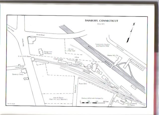
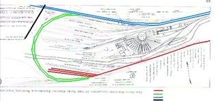
I have an 1896 NH public timetable that shows the NH trains on the Norwalk line operating into one of two stations in Danbury. One was at White Street where the long time NH station (and now the museum) was located. The other station is shown as a Main Street station. Trains using one station do not appear to stop at the other. A 1926 street map of Danbury shows a spur coming off the NH at about the position of the current Metro North station and heading due west to Main Street. Was this the track to the Main Street Station ? If so, it looks like a stub end station. Does anyone know anything about the Main Street station ? It does not appear in the early 1900 public timetables. Thanks for any help you can provide.

  by Johnny F
 
This is a VERY general summary:

The Main St station belonged to the Danbury & Norwalk RR. This railroad was eventually taken over by the Housatonic RR. The Housatonic came into Danbury via the NY&NE, whose Danbury station was opposite the current Danbury station at White St. Rather than relocate the existing station facilities and right-of-way by building a new connection between the Housatonic/NY&NE and the D&N, the "loop" track connection was put in place to connect all the railroads and provide a direct route from Norwalk to Pittsfield. After the loop was built, the Main St station required a backing move and was fairly inconvenient. There were 2 Danbury stations for awhile, but the Main St station and old NY&NE station were eventually closed and a new (current) station was built at White St.
  by Tom Curtin
 
Good summary!

The D&N stub-end Main Street station (built in the 1870's) was located at 265 Main St., where the downtown post office currently sits. According to recollections from my grandfather (1871-1958) when I was a little kid, that station was a real ramshackle hole.

Glad you pointed out the "loop" predates the White Street station. A lot of people don't realize that.

The NY&NE station (built 1881) was on the north side of the Maybrook Line and was picked up and moved not right after the White St. station was built (1903), but several years later (1906), when the Maybrook Line was double tracked through Danbury. The New Haven sold that whole area on the north side of the Maybrook to Leahy Fuel Co. decades later, in late 1950. Both the NY&NE station and the old Danbury Division HQ building were included in that sale and both structures still stand and belong to Leahy's today.

The "loop" was originally single track and remained so for a while. I am not sure when it was double tracked but I know it was after World War I, and I believe it was proably done when the Norwalk-Danbury main was electrified in 1925.

A collection of sidings remained in the area that is now "Danbury Green" until relatively recent times, I would say after WW II. Those are what you see on your 1926 map. In the 50s the city bought all that for a municipal parking lot. One lone remaining siding continued to serve Swift Premium meats (on Ives St.), and may even have remained in service past the end of the New Haven --- I don't recall for sure how long. That siding actually ran through the parking lot! Today, with Patriot Drive, and the parking garage, and the Green occupying that whole area, it may be hard for you to picture what had been there previously.
  by rrxing
 
any way any maps of these danbury track arrangements could be scanned and added to this post? i have never quite understood danbury with the d&n, the ny&ne, the housatonic, the ny, housatonic and northern, etc.! thanx, bob

  by Johnny F
 
Image

Image

I'll try, but I'm limited in what I can do. These scans are from "In the Shoreline's Shadow" by L. Peter Cornwall.

Both scans have North to the top of the page. The first shows the D&N coming into Danbury. The second shows the later configuration:

RED is the D&N (roughly the first scan)
BLUE is the NY&NE
GREEN is the connecting loop track
BLACK is White Street

The NY&NE connected with the Housatonic further east (right). Hope this helps a bit.
  by rrxing
 
thanx for doing the scans. i actually located the cornwall book and saw these but others may like to see them too. the top map is the 1876 arrangement when the d&n was the only railroad in town. your 1896 timetable is a useful clue as to when the loop was put in, probably shortly after 1892 when the new haven leased the housy that had already leased the d&n. obviously it is in by 1896. the bottom map is 1941 long afterward.

check out this link.

http://www.cthistoryonline.org/cdm-cho/ ... DMROTATE=0

this 1875 map shows the main st. depot as well as a housy depot on white st. where the 1903 new haven station (danbury railway museum, today)
stands. there was an nyne depot across from the housy depot after 1881 when the nyne came through. the 1903 station eliminated the three older depots as well as the backup moves into the old main st depot by northbound and possibly southbound trains as well.

let me know if the link doesn't work and i'll try again.

the previous post that said the housy came in via the nyne is incorrect. it came in 1874 by way of its lease of the ny, housy and northern which had built its own track into danbury from brookfield. that is what you see on the 1875 map as the housy. the nyne built its own r/o/w into danbury in 1881.

bob
  by rrxing
 
slight misstatement: the d&n was not the only railroad in town in 1876. the housy had come in 1874.