• LIRR Native American Names- NEW PAGE

  • Discussion of the past and present operations of the Long Island Rail Road.
Discussion of the past and present operations of the Long Island Rail Road.

Moderator: Liquidcamphor

  by nyandw
 
http://www.trainsarefun.com/lirr/Native ... -names.htm

A long term "work in progress" that you folks might have additional insight. :-) Examples:

Image
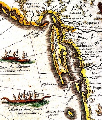
A Dutch map (1635) of Northeast Native territories shows the Matouwac territory of Long Island.

Image
Matawok: (Forest Hills West): A short-lived station immediately east of the junction (Whitepot Jct.) of the Main Line and Rockaway Beach Line. Station at 66th St. Built for the Matawok Land Co. which was developing Forest Hills West. 400' wooden platforms with access by means of two spans over the Main Line and seven spans over the Rockaway Line. Opened 06/25/1922 and abandoned 07/1925 Vincent Seyfried

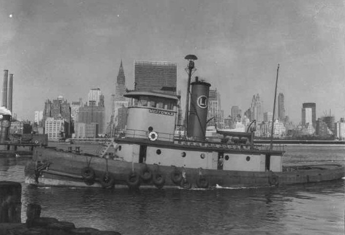
Meitowax Tug One of the names of Long Island derived from"the land of the periwinkle" or "country of the ear-shell"
Image
  by MattAmity90
 
I'm pretty sure Amityville is named after the Amity Tribe, with Ville being Village.

Lindenhurst is NOT an Indian Tribe, the name comes from an English town, and was previously known as Wellwood.

Babylon? Maybe, but more than likely named after Alexander the Great's conquering of the Babylonians during his trek.

Seaford is definitely not Indian, because their is a Seaford in England and in Maryland, same thing with Westbury. I'm pretty sure Freeport, Rockville Centre, Lynbrook is just Brooklyn inverted, Valley Stream is probably named after an individual or is known and self-explanatory, any town with the words "Port" or "Ville" are not Indian, Bellmore is known as the Bellmores, Bethpage might be something, and of course Hicksville is named after the LIRR's second president Valentine Hicks and it happens to be a village or they established it as a village.
  by nyandw
 
MattAmity90 wrote:I'm pretty sure Amityville is named after the Amity Tribe, with Ville being Village.

Not at all. See internet: Google

Lindenhurst is NOT an Indian Tribe, the name comes from an English town, and was previously known as Wellwood.

Agree: Were did I indicate this?

Babylon? Maybe, but more than likely named after Alexander the Great's conquering of the Babylonians during his trek.
Seaford is definitely not Indian, because their is a Seaford in England and in Maryland, same thing with Westbury. I'm pretty sure Freeport, Rockville Centre, Lynbrook is just Brooklyn inverted, Valley Stream is probably named after an individual or is known and self-explanatory, any town with the words "Port" or "Ville" are not Indian, Bellmore is known as the Bellmores, Bethpage might be something, and of course Hicksville is named after the LIRR's second president Valentine Hicks and it happens to be a village or they established it as a village.
I did not in any way indicate that the above locales were Indian derived.

Perhaps the site has a problem, please advise. http://www.trainsarefun.com/lirr/Native ... -names.htm Thanks. :-)

BTW: WAUWEPEX Means "place of good water" is referenced already. :-)
  by Mr rt
 
Wauwepex was a Cub Scout camp that included Great Pond.
It was re-named for a benifactor,
but is called Camp Tick by many.
  by Crabman1130
 
Mr rt wrote:Wauwepex was a Cub Scout camp that included Great Pond.
It was re-named for a benifactor,
but is called Camp Tick by many.
It's Deep Pond.
  by nyandw
 
Crabman1130 wrote:
Mr rt wrote:Wauwepex was a Cub Scout camp that included Great Pond.
It was re-named for a benifactor,
but is called Camp Tick by many.
It's Deep Pond.
It's out east near the Scout Camp Baiting Hollow as I recall.
  by Crabman1130
 
nyandw wrote:
Crabman1130 wrote:
Mr rt wrote:Wauwepex was a Cub Scout camp that included Great Pond.
It was re-named for a benifactor,
but is called Camp Tick by many.
It's Deep Pond.
It's out east near the Scout Camp Baiting Hollow as I recall.
Baiting Hollow is the Suffolk County Council camp.
Schiff Scout Reservation, which is where Deep Pound is, is the Theodore Roosevelt Council camp. (Nassau County) It's located on Wading River Manor Road between Rt 25a and Rt25.
Schiff also has LIRR hack C57.


Image
  by Doc Emmet Brown
 
Mineola Means "Land Of Many Lawyers"
  by murfunit
 
Based on reading about the Long Island Rail Road, specifically Ziel's book, it was mentioned that the railroad itself assigned Native American names to its station stops during the late 1800s. Amityville took on that name as the friendly Bay Village in the late 1800s despite having a sizable native population of The Narrasketuck Tribe at the time of European settlement in the 1600s. Lindenhurst has gone through several name changes initially being called Breslau, then Wellwood, and now Lindenhurst reflecting German settlers from Europe. The Massapequas are an example as is Wantagh of the railroad assigning names of native Americans to its stops.
  by nyandw
 
murfunit wrote:Based on reading about the Long Island Rail Road, specifically Ziel's book, it was mentioned that the railroad itself assigned Native American names to its station stops during the late 1800s. Amityville took on that name as the friendly Bay Village in the late 1800s despite having a sizable native population of The Narrasketuck Tribe at the time of European settlement in the 1600s. Lindenhurst has gone through several name changes initially being called Breslau, then Wellwood, and now Lindenhurst reflecting German settlers from Europe. The Massapequas are an example as is Wantagh of the railroad assigning names of native Americans to its stops.
Station Names Changes: http://www.trainsarefun.com/lirr/lirrstationnames.htm Lindenhurst

WARRASKETUCK : a creek on the bounds between South Oyster Bay and Babylon towns, at Amityville. Andros's patent for Oyster Bay town, Sept. 29, 1677, says: -"Beginning on the east, at the head of Cold Spring Harbor, and running a southward course across the Island to a certain river called by the Indians, Warrasketuck, etc.," (Thompson, vol. i., p. 488). Variations: Wanasketuc, 1797; Waunskittuc, 1860; Narraske-tuck, on some local maps. Allowing for the Indian Place-Names
permutation of r and n, Warrasketuck represents Wannasquetuck, "the ending or point creek," because the creek formed the southern end of the boundary. The components of the word would thus be wannasque, corresponding to Massa-
chusetts wanashque, "at the end of," "on the top of"; -tuck, "tidal stream," "creek."

Wikipedia (not always valid, BTW) Huntington settlers first visited the Amityville area in 1653 as a source of salt hay. Chief Wyandanch granted the first deed to land in Amityville in 1658.[1] The area was originally called Huntington West Neck South (it is on the Great South Bay and Suffolk County, New York border in the southwest corner of what once called Huntington South but is now the Town of Babylon. According to village lore, the name was changed in 1846 when residents for its new post office. The meeting turned into bedlam and one participant was to exclaim, "What this meeting needs is some amity". Another version says the name was first suggested by mill owner Samuel Ireland to name the town for his boat, the Amity.[2]

I have found no references to Amityville being of Algonquin/Dutch/early English language derivation:
http://www.archive.org/stream/indianpla ... a_djvu.txt
  by nyandw
 
New info added: Image
The grave of Reverend Paul Cuffee, an Indian of the Shinnecock Tribe. In years past, the LIRR engineers would always toot the horn a few times when passing by the Chief's grave.

I believe that tradition has now been lost. Info: Dave Morrison Anyone?

http://www.trainsarefun.com/lirr/odds_ends.htm 5% down the page: REV. PAUL CUFFEE, INDIAN PREACHER:
Image
LIRR #207 eastbound Canoe Place Rev. Paul Cuffee Gravesite

More photos/info: Rev. Paul Cuffee is buried on a tiny plot of land at Canoe Place in Hampton Bays. His grave sits all alone between the Long Island Railroad tracks and Highway 27 (Montuak Hwy), the gravesite having been diminished by development on the Long Island Railroad. It has a stone marker which is weather-worn and broken in two. There is a small white fence around it, erected by his descendants on "Good Ground" which was once all Indian land.

He died on March 7, 1812, at the age of 55 and was buried in an old Indian cemetery about a half mile east of Hampton Bays railroad station, which was at an early period the site of an Indian church belonging to the Shinnecock tribe. Here a simple marble slab was erected to his memory by the New York Missionary Society, which carried the following inscription. "Erected by the New York Missionary Society in memory of Rev. Paul Cuffee an Indian of the Shinnecock tribe. Who was employed by that society for the past thirteen years of his life, on the eastern part of Long Island where he labored with fidelity and success."
  by Doc Emmet Brown
 
Some Engineers still did it while I worked there.
  by nyandw
 
A bit more Amityville info:

Now the below is Wikipedia:
The area was originally called Huntington West Neck South (it is on the Great South Bay and Suffolk County, New York border in the southwest corner of what once called Huntington South but is now the Town of Babylon. According to village lore, the name was changed in 1846 when residen for its new post office. The meeting turned into bedlam and one participant was to exclaim, "What this meeting needs is some amity". Another version says the name was first suggested by mill owner Samuel Ireland to name the town for his boat, the Amity.[2] The place name is strictly speaking an incidental name, marking an amicable agreement on the choice of a place name[3] The village was formally incorporated on March 3, 1894.

BTW: I’ll vote for item[2]above: “Amity” Back in the earlier years of Long Island history upwards to perhaps WW I (prior to major developers naming streets and projects) so many areas where just named for the current/previous land owners. I’ll give you a short list of examples:

Gardiner’s Island/Bay
Vanderbilt Pkwy

And on smaller local levels:
Moffitt Blvd., Islip
Nicholl’s Road, Patchogue
Tuttle’s Creek, Patchogue
Gerard Ave, Patchogue
Roe Blvd, Patchogue

The following is whimsy:

The list goes on and on in every town. It is tied to pre-rail travel as folks went by foot, horse, horse/buggy, and horse/cart. “Where ya going, Sam?” “Hell, I’m off to Lynch’s to deliver the hens” “How ya getin there?” “Heck, taken the ole highway over to Tuttle’s place and crossing over to Lynch’s path...