• is there ANYTHING left of the old Wading River branch?

  • Discussion of the past and present operations of the Long Island Rail Road.
Discussion of the past and present operations of the Long Island Rail Road.

Moderator: Liquidcamphor

  by mad munson
 
Dave Keller wrote:Nice rear view from the parking lot!

Here's a front view:
Image

And Shoreham with North Country Road crossing at grade east of the distant freight house:
Image

Also, the pamhplet is slightly incorrect. The Wading River depot was built in 1895 and the 2nd storey added in 1906. I have a photo of it taken in 1905 and it was still one-storey, and covered with vines. It was a major rebuild, though, along the scale of the renovation made to the original Montauk depot (lengthened in depth and 2nd storey added).

Dave
man, thats when central long island was really like living out in the country. thanks for the input and pics everybody.

  by nyandw
 
Mad Munson: [/quote]
man, thats when central long island was really like living out in the country. thanks for the input and pics everybody.[/quote]

It wasn't only the Central Long Island area. All the Pre-LIRR and LIRR roads added to the colonization of Nassau/Suffolk in the 1850-1890 period.

Look at Patchogue just as the SSRR arrived:

Image
c. 1870

Line extended 1881. Patchogue was still a little village in 1873:
Image

With the advent of the railroad and commerce to follow the area exploded in the next 20+ years. Over perhaps 40 industries served by rail:

Bailey's Mill: Image
The rail yard: Image
Downtown (1/4 mile away): Image

The LIRR really created the population expansion of Long Island Eastbound, just as other USA railroads created the westward settlements.

Best,

  by Dave Keller
 
I have images in my archive of B&QT and Steinway Lines trolleys in Queens in the 1930s.

You'd think they were interurbans running in the wilds of Indiana.

Flat empty fields . . . . trees . . . . . vacant expanses . . . . .

Yup! Queens in the 1930s!!!!!!

Mind-boggling!

While Brooklyn was the largest city in the U.S. until it's incorporation into New York City in 1898, Queens never developed because transportation to the portions east of L. I. City was practically non-existant or poor at best.

With the advent of the EL, the area opened, but much later than most other areas.

And, as Steve said . . . . eastern LI was a whole 'nother ball game. Talk about dinosaur land.

Growing up in Suffolk County in the 1950s, everyone from "the city" told us we lived in "the sticks!" We even had an RFD postal address (that's Rural Free Delivery to you kids :-)) with mailboxes up on a post at the end of your block along with the boxes of those other families on your block. You had to walk up the corner everyday to retrieve your mail and chat with your neighbors at the same time.

You'd never know it now: Not a vacant spot to be had.

Nassau, too, wasn't much better, only their boom arrived earlier than Suffolk. Here's Hicksville - 1937:

Image Hello . . . ello . . .. ello . . . . . ello . .. . . . . .

Dave

  by nyandw
 
Route 24 Hempstead Turnpike terminated at Route 106 Newbridge Rd in East Meadow at some time prior to the advent of the creation of Levittown as I recall. Imagine at this location the Hempstead Plains (a geological unique flat prairie east of the Appalachians) extending flat up to the Hicksville area. This was used as a landing area by wealthy patrons to fly up into the Hicksville Country Club very near the rail line early on

Imagine driving north on 106, Jerusalem Ave, 107, etc from The South Shore and all there would be until Hicksville is flat grass land with low trees. There was a small parcel of this visable at the SE corner of Wantagh Ave and Hempstead Turnpike in front of the Island Trees School (previous name for Levittown area). Target Store is on this site now. :(

Wish I had photos of all this stuff for you folks, but you can google Hempstead Plains, etc. and have a great time.
Best,

  by thrdkilr
 
Nice pictures/drawings, thanks guys. I'm curious though, it's a chicken and the egg kind of thing, from all the pictures I've seen of the LIRR in the early days, like these, it looks like the railroad was built before the people came, and as the population has grown, the LIRR has actually gotten smaller. Was the RR built on speculation? What was the revenue source in the early days? Why did they build such an extensive system before-hand?

  by LIengineerBob
 
THe LIRR was originally built as a "through" route to Conneticut via the ferries on the East end of the island. Thats why it predominatly ran through the "barren" (by todays standards) area right through the middle of the island. :wink: Those more in the know like Mr. Keller can probably give you a much more in depth description!!! :wink:

  by Dave Keller
 
IN a nutshell, the LIRR's MAIN LINE was built as a direct route to Conencticut and on to Boston, because the many rivers and inlets along the southern CT shore couldn't be bridged.

A few years later, newer engineering allowed it to happen and the LIRR's grandiose schemes flopped as the New Haven handled that business.

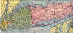
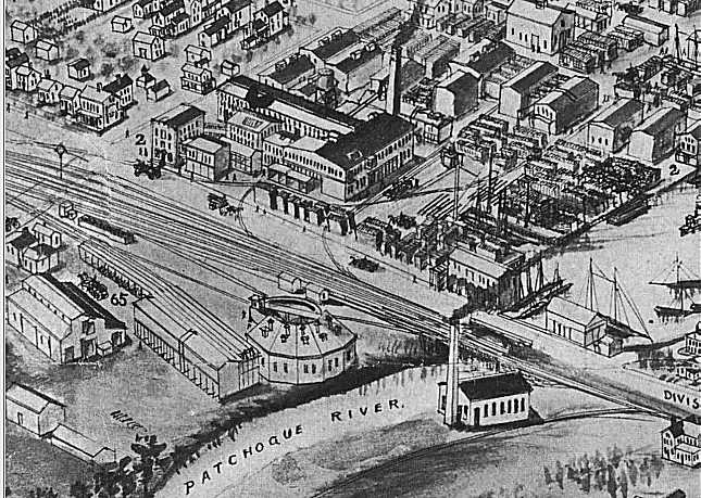
The LIRR was left with a line down the center of no-where-land, miles from the towns for which it had stations.

That was the reason why other railroad companies developed: to service areas without rail service.

When the LIRR acquired the various private roads and incorporated them into their own, they wound up with a goodly-sized rail network.

I guess long-range planning on their parts indicated extending the as-is lines from Port Jeff to Wading River and Bridgehampton to Montauk would have been profitable.

Montauk (and, along the way, the Hamptons) paid off due to the beaches becoming vacation spots as well as the homes of the rich and famous.

East of Port Jeff was still rural back in the 1950s when I was a kid!!!! No wonder the business along that branch took a dump back in the 1930s, at the height of the Great Depression.

Hindsight is great. But making certain decisions at the time may have seemed the "right thing to do" so we really can't blame the railroad or its management at the time. They did what they thought was best.

Some of their decisions were great: electrification of a large portion of the system, branches to the Rockaways and Coney Island, even having thru-trains to help eliminate everybody changing at Jamaica!

Some of their decisions fell flat . . . . :-(

Can't win them all! That's business!

Dave

  by thrdkilr
 
Thank-you Dave, speaking of hindsight and looking at the way things turned out, what would have made for a better system? Perhaps having the PW or Oyster Bay lines continue out to Greenport, keeping the old central to Babylon, maybe a connection out east for the north and south lines, and keeping the southern line pretty much as is? Your 2 cents please...

  by Dave Keller
 
I don't think ANYBODY ever thought that Nassau and Suffolk Counties would have EVER grown to the extent they have.

Had the LIRR been able to know all this, the smart thing would have been to:

1. NOT abandon the Whitestone branch and service that part of Queens as it developed.

2. Develop the Central branch to service the commuters of Plainview and Levittown.

3. Keep the Manorville-Eastport connection as an alternate means to the South Shore.

4. Keep the Port Jeff-Wading River extension to service that portion of the north shore of Suffolk County.

5. Seriously consider a light-rail system between the eastbound and westbound lanes of the LIE while it was under construction with "Park-and-Ride" stations at various points to connect with the rapid transit trains.

6. Continue elevating the Montauk branch along Sunrise Highway while they were on a roll with Valley Stream and Lynbrook and expenses were less than when they continued in 1949 (RVC) up through the 1970s (Amityville, Copiague, Lindenhurst).

7. Never have closed depot buildings and abandoned stations along the Main Line and Montauk branches but develop them for future growth. They were there since the 1840s and abandoned c. 1960-62 . . . what would it have hurt to have left them another 10-20 years and improved train service?

The railroad said that the ridership was poor so train service was cut and stations abandoned. But it's a big circle . . . . IF the railroad had improved service and kept up their stations, the ridership would have INCREASED.

Sometimes you have to invest a little money to eventually make money.

For example, the New Haven laid 4 tracks and electrified their system through southern CT when labor and materials were cheap. Years later, when they needed it, the rails and electricity were already in place.

The LIRR made a great leap with electrification in 1905. Granted, many areas didn't need it AT THE TIME, but the expense that would have been incurred by the Pennsy (LIRR's owners) at the time to extend electrification to ALL terminals that have electrification TODAY would have been MUCH cheaper!! They could have even extended it to Patchogue and Port Jeff at a fraction of what it cost back in 1969 and 1987 (and now)!

Now:

1. Abandoning the Manhattan Beach branch made sense, because the LIRR couldn't compete against the nickel fare charged by the transit system at the time and there was so much duplicate coverage to the beaches, between the LIRR, the BRT and all the trolley lines.

2. Abandoning the Sag harbor branch made sense, because that area doesn't seem to have experienced the growth that, say, Mount Sinai, Miller Place or Rocky Point has exhibited and train service to Sag Harbor was always shuttle service brom Bridgehampton, anyway. I don't know how many people today would want to change at Bridgehampton and wait for a wesbound connection to get to work, then change again at Babylon or Hicksville and/or Jamaica! When it comes to commuting, thru routes work. Connections don't.

Of course . . .. all water under the bridge!

Dave

  by nyandw
 
thrdkilr:

In response to your historical question about the LIRR's reason it came into being, I'll send you to the following sites.

http://rapidtransit.com/net/thirdrail/0103/reif1.html A must read. Start here, a super history... :-)

http://thejoekorner.quuxuum.org/lirrbro ... rr100y.htm
http://www.catskillarchive.com/rrextra/abnyli.Html
http://www.dunton.org/archive/LongIslandRailroad.htm

Bob Andersen expansion maps, FYI: http://www.trainsarefun.com/lirr/lirrmapexpansion.htm
Image

Dave Keller "wrapped it up so well " that I really have little to add. Except: :wink: LIsland's geology played a major role in the early rail lines development. The flat post glacial flood plain in the center of the Island had no major obstacles to cross, near zero grades and no horse crossings to deal with. That's why the Pine Barrens was chosen. High speed all the way to Greenport to get the NY City to Boston traffic. The rail line and investment was purely to get the NY- Boston traffic.

As Dave indicated with the ability to bridge the rivers of southern Connecticut as technology advanced the LIRR rail/steamboat link to Boston died... :(

The rest is history!


Best,

  by NIMBYkiller
 
I thought that Sag Harbor actually did have a few direct trains(from Greenport and LIC)

  by Dave Keller
 
You're thinking of the "Scoot" which ran from Sag Harbor to Greenport and return.

That was long gone by the time the end of the line approached in 1939.

All through the 1930s there was only the gas car as shuttle between BA and SH. (Not a typo: the block signal for the Sag Harbor branch at Bridgehampton was BA, not BH.)

And as for through trains from LIC, once again . . .that was long, long ago in a galaxy far, far away. It pretty much ended when the line was extended from BH to MK in 1895. (again, not a typo: Montauk was MK until 1927.)
Those events were too far in the past to affect abandonment decisions in the late 1930s.

Hence my not mentioning them.

Dave

  by RussNelson
 
Dave Keller:
Don't forget that Robert Moses was able to treat NYC & LI as his private playground.

  by Dave Keller
 
That the man was allowed such control and allowed his own agenda smacks of 19th century NYC Tammany Hall politics! :-(

Dave