• A way to restore North Philly Trolleys?

  • Discussion relating to Southeastern Pennsylvania Transportation Authority (Philadelphia Metro Area). Official web site can be found here: www.septa.com. Also including discussion related to the PATCO Speedline rapid transit operated by Delaware River Port Authority. Official web site can be found here: http://www.ridepatco.org/.
Discussion relating to Southeastern Pennsylvania Transportation Authority (Philadelphia Metro Area). Official web site can be found here: www.septa.com. Also including discussion related to the PATCO Speedline rapid transit operated by Delaware River Port Authority. Official web site can be found here: http://www.ridepatco.org/.

Moderator: AlexC

  by Hal
 
Another "what if" - or at least 'what should be'

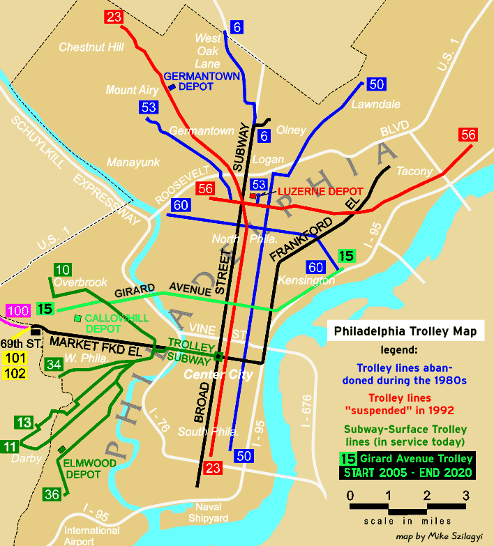
At one time there were several trolley lines in North Philly that ran
out of the Luzerne Trolley Depot, and North Philly had a
rather extensive trolly network-

The 53 to Mount Airy,
the 23 to Chestnut Hill,
the 6 to Cheltenman,
the 50 to Lawndale,
the 56 to Tacony,
The 60 to East Falls and Port Richmond.

Here's the Phillytrolley.org map-

Image


Now that we're seeing those lines lost, I think it's time to be creative about finding a way to make rail transit competitive against busses-
That sugests (to me) that we should duplicate the style of service on the surviving trolley lines, the subway surface lines, and think about taking the Norht Philly Trolleys, and run them into the Broad Street Subway as Subway Surface Lines that run down then loop through Center City.


There are 5 things that would have to be addressed-

1) Use standard gauge track when the North Philly trolley tracks are
restored.

2) Get standard gauge trolleys with street loading on the right and high platform doors on the left.

3) Hang a trolley wire on the Broad Street Subway Express track.

4) Open up the Broad Street Subway's "upstairs" ramps at Erie junction and use the connection to the express tracks for trolleys. Using the express tracks would allow a trolley with high platform loading on the left side to use the Express route's island/left side platforms.

5) Take the stub-end of the Broad Street Express Tracks and the end of
the Locust Street Subway and connect them to form a down town loop so you. This shouldn't be as hard as it sounds, because although the turn is probably too tight for a subway car, a trolley should have a much shorter turning radius.


This would let you route the 5 North Philly surface trolleys into the Broad Street Subway's express tracks at Broad and Erie. That would give North Philly a system of express sevice on the Broad Street line, much the same as the closely spaced cars of the Subway Surface line provide.

In addition to the 5 North Philly Trolely lines that run near Broad and Erie, I'm adding in a hypothetical crosstown trolley route along the Port Richmond Branch's right of way. A Port Richmond crosstown would run from Wissahickon Transportation Center- down Ridge and Kelly Drive, over to Wayne Junction, stop at Broad and Erie, then contine East to the Market Frankford El and end/interconnect with the Route 15 Trolley

These hypothetical "Orange Line Trolleys" would look something like this
(apologies to Mike Szilagyi for scribbling all over his map...)

Image

A North Philadelphia Subway Surface trolley network would restore local trolley service to North Philadelphia- something that helps build the "charecter" of the local shopping district.

It would provide a very fast 1 seat ride from the northern suburbs to Center City and back.

It would also provide a distribution loop around Center City by circulating under Ridge, 8th, Locust and Broad.

Has anyone else suggested something like this in Philly,

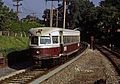
Do any transit systems use PCC's with some kind of high platform loading doors on the left side?


Hal

  by amusing erudition
 
I'm very much in favor of getting streetcars back onto the streets of North Philadelphia, and since several of the routes you mention are gone anyway, I'm even in favor of expanding beyond those (some of yours are going to have to be rebuilt anyway, so why not more?), but here are some concerns about your specific plan as enumerated:

1) The BSS is nearing capacity, and what capacity remains should be used for Boulevard service. Eliminating this capacity will kill any prospect of that getting built, likewise, the inclines at Erie are the flying junction built for expansion that has been earmarked for Blvd. service.

2) Unless you're planning on regauging all track in West Philly, I would keep things simple by leaving cars at broad gauge, permitting equipment transfers and the like. via the current 23 and 15 tracks.

3) If you're going to run these on the express track in the subway, then the doors that are high-level are going to have to be on the <u>right</u> just like the low-level doors for street boarding, and I'm not sure how that would work. Subway express stations are TPTTPT [T=track and P=platform], not PTTPTTP like Penn Station on the New York subway

4) What is your plan for existing Broad Street service, it seem obvious that spur service will be eliminated in favor of trolleys, but what about existing express service (*-see note)? For that matter, are trolleys and rapid transit cars allowed to share tracks?

5) A loop downtown with buildings in the way would be prohibitively expensive, if possible at all. (**-see note) It would have to go two full blocks west and do a 3/4 turn around to access the Locust Subway, but of course...

6) The Locust St. Subway is in use for PATCO

7) It'll be a cold day in hell before the City would let anyone lay tracks and drive poles on East River Drive, but if you were going to build on Ridge then onto a crosstown line why not let the service be on Allegheny which would (a) otherwise not have streetcar service, (b) already connect to the 15 at its eastern terminus (c) also connect to the Subway (albeit at a local station).

8) It'll be similarly unlikely to get permission to run streetcars on Broad Street (operating plan for the 6). Would you let service run on Old York Road (as the out-of-service 6's did to get to Luzerne) or would you prefer to let them enter via the other ramps north of Olney Station.

*If you were going to run all the streetcars in the subway, it would make more sense to have them frequently service the local stations and have the rapid transit cars service express stations only, as is done (ostensibly) with the current Market Street Subway setup (with 19th and 22nd as "local" stations at which the MFL doesn't stop.)

**Also as a point of clarification, if you're using such a huge downtown loop (Broad->Locust->8th->Ridge->Broad), do you propose making it one huge one-way loop, or keeping all segments bi-directional, with some routes going clockwise and some counter-clockwise?

I like the general idea, but there are definitely some flaws to it. I very much would like to see streetcars running on every major street in Philadelphia; certainly Ogontz, Erie, Allegheny, Cecil B Moore/Columbia, and Spring Garden are all wide enough to route streetcars if anyone had the will to do so. I would also be very interested in your answers to these concerns.

-Adam
Last edited by amusing erudition on Sun Jun 20, 2004 6:56 pm, edited 1 time in total.

  by JeffK
 
Intriguing - basically a copy of the existing subway-surface system, replicated northward . . .

A few thoughts and questions:

The need for standard gauge tracks would of course require replacing whatever remains of the broad-gauge infrastructure on the 23, 56, etc. At least the "ROW" (if you will) in the existing street cuts would not have to be expanded. However the cost of removing the existing, possibly buried, tracks could be huge.

What would the effect be of trying to interleave trolley service with subway runs? Or would the express tracks be given over to exclusive trolley service in this plan?

In either case, what would be the implications of the fact that a number of the stations do not have platforms for the express tracks? The trolleys could not make local stops and would be running as a clone of the existing subway express service. Not sure there's anything wrong with that, but it's a consideration.

The loop south of City Hall would have to be worked out pretty carefully. There's already a maze where the existing lines must cross each other. I know virtually zilch about the geology of the area and wouldn't want to try to speculate on the kind of tunnelling needed to put in a second loop,

I don't know of any combination high-platform/low-platform configuration. My first-glance opinion is that it probably wouldn't be too difficult from an engineering standpoint since you wouldn't need traps or anything similar. The only consideration would be the loss of some seating capacity to support two full sets of doors. Note- I don't think using smaller doors on one side, à la the N-5s, would work in an environment where dwell times are critical.

  by Hal
 
amusing erudition wrote: 1) The BSS is nearing capacity, and what capacity remains should be used for Boulevard service. Eliminating this capacity will kill any prospect of that getting built, likewise, the inclines at Erie are the flying junction built for expansion that has been earmarked for Blvd. service.
Well, from what I'd read the BSL still has some capacity left.

From the numbers I'd seen, the 2 track Market Frankford El carries about 2x the traffic of the 4 track Broad Street Subway. Twice the volume on 1/2 the trackage.

Appearently 4 track subway systems are almost unique- New York and Philly, and New York's carris an incredible throughput, while the Broad Street Subway now runs through areas that are MUCH less dense than they once were- North Broad and North Philadelphia as examples- so I'm figuring that as long as the population of Philadelphia had dropped by err, a half a million, and a big portion of the abandoned areas are around the BSL, there's some unused capacity there.
amusing erudition wrote: 2) Unless you're planning on regauging all track in West Philly, I would keep things simple by leaving cars at broad gauge, permitting equipment transfers and the like. via the current 23 and 15 tracks.
Um, but then how would you run broad gauge trolley cars on standard railroad gauge Broad Street Subway Tracks? "Market is Broad and Broad is Standard..." Are you suggesting some kind of dual guage wheels?
amusing erudition wrote: 3) If you're going to run these on the express track in the subway, then the doors that are high-level are going to have to be on the <u>right</u> just like the low-level doors for street boarding, and I'm not sure how that would work. Subway express stations are TPTTPT [T=track and P=platform], not PTTPTTP like Penn Station on the New York subway
Hmm, guess I'm thinking about the MFL & Subway Surface layout at 30th Street and slipped into writing about it's layout rather than the BSL express layout.
amusing erudition wrote: 4) What is your plan for existing Broad Street service, it seem obvious that spur service will be eliminated in favor of trolleys, but what about existing express service (*-see note)? For that matter, are trolleys and rapid transit cars allowed to share tracks?
Well, as I understand it, the big prohibition is against FRA railcars and non-FRA transit vehicles on the same tracks. My understanding is that the focus is on the strength of the vehicles- so that subway cars and subway surface trolleys ought to be ok, rather than the combined weight of the train-in which case, logically, you'd prohibit 1 car subway trains from running on the same track with 6 car subway trains, because there's a 500% weight difference between the different sized trains.
amusing erudition wrote: *If you were going to run all the streetcars in the subway, it would make more sense to have them frequently service the local stations and have the rapid transit cars service express stations only, as is done (ostensibly) with the current Market Street Subway setup (with 19th and 22nd as "local" stations at which the MFL doesn't stop.)
Correct, I was thinking Broad Street Line, but got started writing based on the MFL/Subway Surface configuration with locals on the outside.
It is an interesting idea- if you have enough local Subway Surface Trolleys running in the BSL you don't need as many subway cars- the Subway Surface seems to do well with smaller cars, but much more frequent service.

amusing erudition wrote: 5) A loop downtown with buildings in the way would be prohibitively expensive, if possible at all. (**-see note) It would have to go two full blocks west and do a 3/4 turn around to access the Locust Subway, but of course...
I'm thinking of a connection at Broad and Locust, where the Broad Street tunnel and Locust Street tunnel cross each other.

There would be a height difference, but there is a HUGE open area under South Broad Street from City Hall to Locust Street - Its a 2 story space: 1 story for the BSL line, another for the concourse above it. I would think about raising trolleys up to meet PATCO, and use of that long concourse area under Broad Street as a stop area- much like the 13th Street Subway Surface Stop

That turn shouldn't be any worse than the 90 degree turn the much longer PATCO trains make at 8th and Locust-

amusing erudition wrote: 6) The Locust St. Subway is in use for PATCO
Yes- I'm counting on cooperation. Ideally, as the Chairman of NJT at a train conference in Philly last week, transit systems will have to learn to work together- stop thinking like "turnpikes" of the 1800 that function to maintain a linear amenity, and start thinking like the airlines of the 21st century that focus on taking you where you want to go.

Of course, if SEPTA and PATCO could cooperate, PATCO could run their Subway Cars up the Broad Ridge Spur to the AMTRAK stop at North Broad, or PATCO up to Fern Rock for an easy subway to Regional Rail transfer, and passenges going between PA and NJ might get a more convienent service.

Doing that would free up track slots on the 8th and Locust Street Subways
amusing erudition wrote: 7) It'll be a cold day in hell before the City would let anyone lay tracks and drive poles on East River Drive, but if you were going to build on Ridge then onto a crosstown line why not let the service be on Allegheny which would (a) otherwise not have streetcar service, (b) already connect to the 15 at its eastern terminus (c) also connect to the Subway (albeit at a local station).
Alleghenny would work nicely for restoration

I drew in a trolley line along part of the Port Richmond Branch because that would be a perfect allignment for a cross town express trollly service.
The Port Richmond Branch from East Falls to Port Richmond wharves is huge- many tracks across, so there should be space to run 2 trolley tracks, and that opens the possibility of a dedicated ROW from the Route 15, MFL, BSL to East Falls-

I said Kelly Drive because I really think a crosstown express that comes close to the Wissahickon Transit Center should connect there.
Part of the long term recreation plan for the city includes rebuilding a bicycle bridge on the old Ridge Ave Trolley bridge foundation to carry bicycle traffic- that got me thinking about better connections there.
I'm only thinking of trolleys on the short section of Kelly Drive from Lincoln Drive to Falls Bridge- that's necessary to avoid the cost of tunneling under the Gustine Lake interchange between City Line, Ridge and Lincoln Drive- but a route along Ridge would work instead.
amusing erudition wrote: 8) It'll be similarly unlikely to get permission to run streetcars on Broad Street (operating plan for the 6). Would you let service run on Old York Road (as the out-of-service 6's did to get to Luzerne) or would you prefer to let them enter via the other ramps north of Olney Station.
That would make the most sense to run underground. There are supposed to be ramps heading up to ground level at Olney Station,
it would make sense to use them.
amusing erudition wrote: **Also as a point of clarification, if you're using such a huge downtown loop (Broad->Locust->8th->Ridge->Broad), do you propose making it one huge one-way loop, or keeping all segments bi-directional, with some routes going clockwise and some counter-clockwise?
Those would run both directions- a 2 track connection at Broad & Locust to make a more useful distribution loop through Center City going either way. That way you actually have easy access from the Avenue of the Arts to 8th Street for an easy walk to Old City, or from North Philly to Locust- which is quite close to much of the Restaurant revival and "Blocks Below Broad" along the 13th Street Corridor- Not a bad idea to actually have a revitilization corridor with Subway stops at both ends, and actually have a plan to use those subway stops.

amusing erudition wrote: I like the general idea, but there are definitely some flaws to it. I very much would like to see streetcars running on every major street in Philadelphia; certainly Ogontz, Erie, Allegheny, Cecil B Moore/Columbia, and Spring Garden are all wide enough to route streetcars if anyone had the will to do so. I would also be very interested in your answers to these concerns.
Of course there are flaws, but it's simply looking at something that does work- West Philly Trolleys- and looking at the increase in housing prices in
Spruce Hill and other Streetcar suburbs that provide easy access to Center City, and boot strap that a way to revitilize areas and make them competitive is to copy what works elsewhere in the city.

Hal

  by walt
 
Building the restored North Philadelphia streetcar lines using standard guage would requre repeal of the 1857 Act of Assembly ( State Legislature) which required the wide guage. That Act is why the current and former Phila Streetcar lines were built using the wide guage. ( Baltimore had similar legislation, passed by the city council, and used an even wider streetcar guage). SEPTA Route 100 ( The Philadelphia & Western Railroad) was built under a railroad charter ( rather than a street railway charter) and was, therefore not subject to the 1857 Act. I don't think there was any legal requirement that the Market Street Subway-Elevated be built using wide guage, but since it was built by the streetcar operator ( Philadelphia Rapid Transit) it was built using the wide guage anyway. Obviously when the city built the Frankford "extension", wide guage was also used to allow for through operation between 69th Street and Frankford.

  by amusing erudition
 
Hal wrote:Well, from what I'd read the BSL still has some capacity left.

From the numbers I'd seen, the 2 track Market Frankford El carries about 2x the traffic of the 4 track Broad Street Subway. Twice the volume on 1/2 the trackage.

Appearently 4 track subway systems are almost unique- New York and Philly, and New York's carris an incredible throughput, while the Broad Street Subway now runs through areas that are MUCH less dense than they once were- North Broad and North Philadelphia as examples- so I'm figuring that as long as the population of Philadelphia had dropped by err, a half a million, and a big portion of the abandoned areas are around the BSL, there's some unused capacity there.
Just as a clarification, the North Side El in Chicago (not <b>sub</b>way per se, but heavy rail rapid transit) is also 4-track local/express, with the express tracks on the outside!

Um, but then how would you run broad gauge trolley cars on standard railroad gauge Broad Street Subway Tracks? "Market is Broad and Broad is Standard..." Are you suggesting some kind of dual guage wheels?
Here's what I counter-propose: give the local tracks of the subway over to trolleys. Regauge those tracks by adding a third running rail until BSS local service ceases (it's going to be easier than regauging the street trackage). Run Broad Street Cars from Pattison to Walnut-Locust and then on the <u>express tracks</u> from W-L to Fern Rock, and W-L to the Boulevard terminal at Southampton Rd. The express tracks south of Walnut-Locust merge into their respective local tracks (from my experience on Sports Expresses) so that through connection should be easy. Disconnect the local tracks from the express tracks south of W-L and then create the loop. If you want the big loop using Locust, fine, though I think that would be awkward; both in making the connection and getting back tracks from PATCO, plus from how I'm interpreting it, you would close 15th-16th (?). Otherwise, it would just be a smaller loop connecting the two local tracks possibly via an underpass. You would then have heavy rail running express from two northern terminals all the way down to the Center City and local to South Philly, and local service provided on North Broad by streetcars (all cars south of Erie and all but the 6 using the Erie ramps along with BSS-Blvd cars, and the 6 serving as locals from Erie north and using the ramps north of Olney.)

If you want to talk about parallels to West Philly, this is it: Express stations served by trolleys and subway cars; local stations served by trolleys, trolleys exiting the subway at two different locations (Olney/Erie, 36th/40th), and the rapid transit service continuing further than trolley service (Pattison = Frankford, Southampton = 69th St.).
Hmm, guess I'm thinking about the MFL & Subway Surface layout at 30th Street and slipped into writing about it's layout rather than the BSL express layout.
Presume the service as above with trolleys running local. The platform heights could be solved at express stations with a high door on the left. It could be solved at local stations by high-doors on the right. It would need low doors on the right for street boarding. See SF Muni cars for examples (seen here in front of SBC Park), they're quite good and would be <u>perfect</u> for this situation; they have 4 doors per side, ALL of which can open either high or low (through automatic steps). Further, they can be MUed if necessary.
Of course, if SEPTA and PATCO could cooperate, PATCO could run their Subway Cars up the Broad Ridge Spur to the AMTRAK stop at North Broad, or PATCO up to Fern Rock for an easy subway to Regional Rail transfer, and passenges going between PA and NJ might get a more convienent service.
You're still going to have PATCO sharing track with trolleys, something they might not be thrilled with. They would also be deprived of all of their Center City stations in favor of some stops in desolate North Philly. Isn't most of PATCO traffic in Pennsylvania people commuting from their homes in NJ to their jobs downtown? I still think that usage of the Locust-8th subways must be examined.
Allegheny would work nicely for restoration

I drew in a trolley line along part of the Port Richmond Branch because that would be a perfect allignment for a cross town express trollly service.
The Port Richmond Branch from East Falls to Port Richmond wharves is huge- many tracks across, so there should be space to run 2 trolley tracks, and that opens the possibility of a dedicated ROW from the Route 15, MFL, BSL to East Falls-
Both then. I think Allegheny is a nice wide street that would be fine with local community service even if the rail ROW is used for connecting express service.
That would make the most sense to run underground. There are supposed to be ramps heading up to ground level at Olney Station,
it would make sense to use them.
And these ramps have been incorporated into my plan (see above).

-Adam
Last edited by amusing erudition on Mon Jun 21, 2004 2:55 pm, edited 2 times in total.

  by Hal
 
walt wrote:Building the restored North Philadelphia streetcar lines using standard guage would requre repeal of the 1857 Act of Assembly ( State Legislature) which required the wide guage.

That Act is why the current and former Phila Streetcar lines were built using the wide guage. ( Baltimore had similar legislation, passed by the city council, and used an even wider streetcar guage).

SEPTA Route 100 ( The Philadelphia & Western Railroad) was built under a railroad charter ( rather than a street railway charter) and was, therefore not subject to the 1857 Act.

I don't think there was any legal requirement that the Market Street Subway-Elevated be built using wide guage, but since it was built by the streetcar operator ( Philadelphia Rapid Transit) it was built using the wide guage anyway. Obviously when the city built the Frankford "extension", wide guage was also used to allow for through operation between 69th Street and Frankford.
Interesting point-

Now I'm curious, what was the El "classified" as -
an elevated trolley or an elevated railroad?

I ask because it sounds like the Broad Street Subway would have to have been classified as un underground railroad in order to allow it to use standard gauge tracks, suggesting that like the P&W lines it was built under some form of railroad chartrer, because if it were considered an underground trolley it would have requried Trolley-wide gauge tracks?

I'd seen a reference in an old set of plans for a "PRR Subway indicating a connection between Suburban Station and the BSL north of City Hall, but never ascribed any significance to that.

Hal

  by walt
 
Hal wrote:
Of course, if SEPTA and PATCO could cooperate, PATCO could run their Subway Cars up the Broad Ridge Spur to the AMTRAK stop at North Broad, or PATCO up to Fern Rock for an easy subway to Regional Rail transfer, and passenges going between PA and NJ might get a more convienent service.

Hal
This is ironic---- prior to the 1960's era extension of the old Bridge Line from the Broadway Station in Camden to Lindenwald and operation of that entire line by PATCO, the Bridge Line was operated by the old PTC as a part of the BSS operation. ( The original 1930's Bridge Line Cars were compatible with the BSS equipment and wound up on the BSS after PATCO took over) During that earlier era, both the Bridge Line and the Ridge-Broad Spur used the same lower level station at 8th & Market, the Bridge Line trains continuing on to 16th & Locust, and the Ridge-Broad spur terminating at 8th street. So unless it was removed by PATCO, there ought to be a crossover just north of the 8th Street Station with a connection into the Ridge-Broad Spur which would make the PATCO through service ( into the BSS) easily accomplished.

You also might take a look at PRT-PTC transit maps for the era prior to 1955 ( the great NCL bustitution) and you will see where streetcar lines used to be located ( essentially "all over the place")

Prior to the opening of the Market Street Subway, both trolley and rapid transit, the current subway-surface lines, with the exception of what became Routes 13 and 36,( PRT did not use route numbers until after the 1911 introduction of the original Nearside cars, which was several years after the opening of the trolley subway) along with what later became Routes 31, 37 ( the Chester Short Line) and 38 all ran on the surface of Market Street all the way to the Ferries at Front Street. ( Route 13 ran on Chestnut and Walnut until the 1950's extension of the trolley tunnel was opened, and Route 36 replaced Route 37 in the subway at the same time. Routes 31 & 38 were bustututed also at the same time) Congestion was so bad on Market Street when the subway was built that creating the subway surface lines was intended to, and did, greatly relieve the surface congestion on Market Street.

  by walt
 
Hal wrote:
Interesting point-

Now I'm curious, what was the El "classified" as -
an elevated trolley or an elevated railroad?

I ask because it sounds like the Broad Street Subway would have to have been classified as un underground railroad in order to allow it to use standard gauge tracks, suggesting that like the P&W lines it was built under some form of railroad chartrer, because if it were considered an underground trolley it would have requried Trolley-wide gauge tracks?

I'd seen a reference in an old set of plans for a "PRR Subway indicating a connection between Suburban Station and the BSL north of City Hall, but never ascribed any significance to that.

Hal
I suspect that the Market Street Subway-Elevated would have simply been classified as an elevated railroad. I don't know whether there was any legal requirement that the PRT use the wide ( trolley) guage, as it is clear that the MSSE was never a street railway. The only factor that I can see that would have created a legal requirement that it be wide guage would have been that it was built by the PRT-- which operated under a street railway charter and might have been required to build anything it built using the wide guage. This, however, is speculation. The reason for the wide guage requirement for streetcars, ( there are two most commonly cited--- one to allow wagons to ride on the rails during the days when many streets were not paved, and to keep standard sized railroad freight cars from being operated on the city streets) did not ever exist with respect to the "El". I have not seen anything, yet, which gives a definative reason why the "El" is wide guage, except that it was built by the PRT.

  by Wdobner
 
In reference to the first post and subsequent posts on turning the BSS local into a LRV operation:

Perhaps a better idea (or at least a more minimalist, cheaper one) would be to simply turn the 6, 23, 50, 53, and 56 at Erie in an underground loop under or adjacent to the BSS Erie Ave stop. The transfer would be free, ADA compliant and, if possible, level, I'd envision something similar to Juniper St here in Philly, or like the Harvard busway in Boston. This way you retain the higher passenger per sq foot of a rapid transit line, but do not have dozens of trolleys per hour descending on the traffic that pervades the intersection of Broad and Erie. Doing an underground trolley loop eliminates issues relating to dual gauging or regauging, specialized rolling stock, clearance for overhead catenary or 3rd rail equipped LRVs, platforming ADA compatible (presumably) low floor LRVs at high BSS platforms, and any regulatory issues the FTA or FRA would raise over the mingling of subway and trolley trains (likely minimal, but still possible).

I suppose the 50 would run east-west on Erie for a short distance with the 56 to reach the terminal. It also might make sense to drop the 53 and just find a way to through-route 56 trolleys down it, keeping Venango loop for a layover yard and deadhead track. I might also go so far as to say through-route the 23 onto the 50 or 6, but that might be a bit extreme. The good thing with through-routing would be that it'd eliminate the need for looping the trolleys, simplifying construction, however might make moving pedestrians from the LRVs to the subway more difficult. Also there's the historic perspective to consider, I think the 23 is the longest trolley line in North America, it'd be a shame to loose that, and I think it'd be friggin cool to see trolleys cross Market St on 11th and 12th again. Perhaps a bypass could be built along with a surface loop to turn trolleys from the south of Erie. Thus the 23 schedule would consist of a combination of two short turns and a full trip run with trips similar to Chestnut Hill to Erie, Erie to Oregon and Chestnut Hill to Oregon. The 6 would run almost exactly as it used to, except that the ridiculous deadhead run from Luzerne to Olney would be eliminated, and the trolleys run in service down Old York Ave or something similar. I hate to run them parallel to the BSS, since they'll likely sap ridership from each other, but I don't see much other way to do things, perhaps railfans will make up a lot of the riders :).

As for a base of operations: Now that Luzerne is dead and gone, I don't see why Midvale Depot cannot be used, it's got an expansive area in which a rail depot to support 200-300 LRVs could be built. Pull-ins and -outs could be made onto the 53 on Clarissa, the 56 on Erie via Hunting Park, or onto deadhead track on Wissahickon to reach the 56. It would remain to be seen if the 15 should be moved to the new LRV depot on Midvale's property, such a move would require a lengthy deadhead move, but it would consolidate a new LRV fleet and all their associated spare parts at a single location. I suppose I should explain that the 15 would get new LRVs and trade their PCC IIs to the Subway Surface and perhaps a recreated Welcome Line in exchange for new low floor LRVs.

Finally the 60 would be restored almost exactly as it was, except with the same low floor LRVs the 6, 23, 50,53 and 56 would get. I'd pull for the Skoda 3T Mr. Erudition showed me, but any will do, provided they don't end up like the Type 8s. As long as it's rail and won't become a major target for the anti-public transit forces I'll be happy.

  by amusing erudition
 
This is an interesting idea as well. (following the West Philadelphia parallel, it's 40th St. diversion service). Through-routing the 53 and the 56 is a good idea (keep 23rd/Venango for short-runs and the like).

As to routing 50 trolleys onto Erie, it would be no different connection-wise to what the 75s did before they were tracklessed (trolleybustituted?) 75s shared Wyoming trackage with 50s and they both turned onto 5th St. with the 47. The 75s turned onto Erie and the other two forged southward. It would be an interesting trackless/trolley combo on Wyoming, one that must have existed before there; in SF tracklesses and trolleys share the hot wire on Market Street, and a similar thing could be done here.

You are, I believe, correct about the 23's length at least as it was the longest route in the US (or North America), but I believe it was superseded by a foreign line. If they restarted a north Philadelphia trolley network, they would have to keep the 23 tracks at least for non-revenue and special runs between the North and West Philadelphia networks; it's just nonsense not to.

Midvale should be able to fill in for Luzerne, and Germantown is still there and could theoretically be used for some of it. For Midvale you'd need non-revenue trackage on Wissahickon from 23rd to Midvale, but that's barely anything. If 56's operated short turns to 23rd/Venango, there wouldn't be much of any deadhead move from their end, if not the dead-head run would only be from where the 53 turns off (16th I believe)

I think the PCCs can't operate in the tunnel because of the signaling. I would prefer the PCCs be used on the 23 through Chestnut Hill (it's historic!) instead, along with new streetcars for all North Philly lines.

There may be a newer version of Skoda's streetcar, the 10T is newer and streamlined, but double-ended. But you could cross the 10T with the 3T for a new single-ender, or just run them double ended! I still must say that if you were going to run them underground to a terminal, it would be nice to have high-platform capability. You could also put high-platforms at their other ends (Cottman, Ogontz, Knorr (or Fox Chase!), and Chestnut Hill Loops) and major intermediate stations if there's at all room for high-platforms. If you wanted the high-platform access, you could use something like the Bredas (not Type 8s*!) in San Francisco which go high, go low, have lifts, and are generally spiffy. Making Erie station wholly accessible couldn't hurt either.

Regarding 6 service on Old York Road, I wouldn't see it so much as competing with the BSS as competing with the C, especially if it has the accessibility that the BSS lacks and that the C provides. In fact, if the 6 provided service on Old York Road, you could get rid of the western fork of the C entirely, with service north of Olney provided by the 22, and south of Olney by the 6 on closely parallel York Road. C's could run their eastern route to Fern Rock only.

-Adam

* I am aware that "Type 8" is a Boston designation and therefore the same vehicles in San Francisco would not technically be "Type 8s." but they are in fact two different Breda vehicles, and I've heard nothing but good about Muni's Bredas

  by JeffK
 
OK, this is veering a bit off the N. Phila topic, but one possible reason broad gauge was chosen for the Market Street line was the plan that it would share service with Red Arrow trolleys. Merritt Taylor at one point had some cars that were supposedly capable of running on both lines, assuming the installation of either overhead on the MS or third-rail shoes on the trolleys.

I'm not sure which was the chicken and which the egg, though - did Taylor plan through-running because the two lines were already the same gauge, or was the gauge chosen to permit joint service?

  by Hal
 
Wdobner wrote: Perhaps a better idea (or at least a more minimalist, cheaper one) would be to simply turn the 6, 23, 50, 53, and 56 at Erie in an underground loop under or adjacent to the BSS Erie Ave stop.
Well, the big reason I'd though about a Subway Surface line is, it appears that the upstairs tracks are Erie are at ground level-
it's not an underground conection.

I've read that -per the 1947 subway extension plan- the upper level of the Erie connection is at the same level as the adjacent Port Richmond Branch - they're separated by the south bridge abutment of the span at
Broad and Erie OVER the Port Richmond Branch.

From the WHYY Channel 12 series, there's a tour of the Broad Street Subway, that mentions storing 4 trains (?) in the "upstairs" - that sounds like it's a fully 4 line flying junction setup - so the trolley connections would not impede a Broad Street Subway Extension.
Wdobner wrote: This way you retain the higher passenger per sq foot of a rapid transit line, but do not have dozens of trolleys per hour descending on the traffic that pervades the intersection of Broad and Erie.
That's what's so nice- the connection is right there at ground level-
and it will be much easier for the trolleys to cross under Broad Street, rather than cross the traffic


That's the other nice thing- you'd enter the Broad Street Subway from the area under the Broad Street OVER Port Richmond Branch- that used to be a HUGE railroad trunk line- Port Richmond was the largest tidewater railroad in the world at one time.
Wdobner wrote: Doing an underground trolley loop eliminates issues relating to dual gauging or regauging, specialized rolling stock, clearance for overhead catenary or 3rd rail equipped LRVs, platforming ADA compatible (presumably) low floor LRVs at high BSS platforms, and any regulatory issues the FTA or FRA would raise over the mingling of subway and trolley trains (likely minimal, but still possible).

Yes, and I think this would work great as a prelude to a single seat service. As above- you don't necessarily need an underground loop- the Broad Street subway cars could run up to the surface, have a cross station interchange-

But, all in all, I think that a one seat ride from North Philly will be the simplest way to get the trolley service back by speeding up the times to Center City.

I've ridden the Route 23 Bus from Chestnut Hill to Market Street-
It's SOO MUCH faster to hop on the BSl, then MFL to 11th Street that I think you could literally catch the NEXT bus if you hop forward using the BSL.


Hal

  by amusing erudition
 
Hal wrote: Well, the big reason I'd though about a Subway Surface line is, it appears that the upstairs tracks are Erie are at ground level-
it's not an underground conection.
They're at the level of the Port Richmond Br. but that's not ground level, it's below grade. Sure it's on the surface, but the branch passes below every street in the area, including both Broad and Erie, so the connection isn't just turning off the street.
From the WHYY Channel 12 series, there's a tour of the Broad Street Subway, that mentions storing 4 trains (?) in the "upstairs" - that sounds like it's a fully 4 line flying junction setup - so the trolley connections would not impede a Broad Street Subway Extension.
Couldn't they just be very long stubs? I'm pretty sure those are only two ramps there that start and end between the local and express tracks in their direction and merge into both. It's also possible that these were the shorter spur trains, which I believe used Erie Over as a northern terminus for a period.
That's what's so nice- the connection is right there at ground level-
and it will be much easier for the trolleys to cross under Broad Street, rather than cross the traffic
I still say that this isn't ground level. The only way this would work is if you got all the cars to 11th and Erie, turned them northbound and ramped them down onto the PR Branch, and thence into the subway 3 blocks west and 4 blocks north. For cars like 50 and 56, this isn't a huge inconvenience, but for the 6 and 23, it's horribly out of the way.
Yes, and I think this would work great as a prelude to a single seat service. As above- you don't necessarily need an underground loop- the Broad Street subway cars could run up to the surface, have a cross station interchange
Run the Broad Street cars up to the surface and then back down into the subway to continue north? That sounds worse than building the underground terminal which would really only need two access points, one east of Broad on Erie (6, 50, 56) and one west of Broad on Germantown (23, slightly relocated 53) or one west of Broad on Erie (53, slightly relocated 23). (i.e. both the 23 and 53 would move to a common routing south of Wayne Junction.)

I think these portals could be fashioned more like the Green Line (B/C) portals in Boston than 40th Street here. The length of those tunnels to get down to the first level below the surface is about 150-200 yards. If you started descent right after Old York (when 6's turned onto Erie), you would probably be able to get down below the Erie Station with a normal descent rate. On Germantown, it would have to be between Germantown and Pike and Germantown and Luzerne to get down below Erie Station. On "Erie West" it would need to be right after the cars turned off Pulaski.

If you wanted to get the cars to the level of the Erie Station, that's even easier... possibly to create a connection or an even more grandiose station with ptTPTTPTtp [T=Heavy Rail, t=Streetcar, P=High, p=Low] and then just cross them from one side to the other under the BSS at a point north or south of there.
But, all in all, I think that a one seat ride from North Philly will be the simplest way to get the trolley service back by speeding up the times to Center City.

I've ridden the Route 23 Bus from Chestnut Hill to Market Street-
It's SOO MUCH faster to hop on the BSl, then MFL to 11th Street that I think you could literally catch the NEXT bus if you hop forward using the BSL.
If it's "SOO MUCH" faster when you transfer to the BSS currently, why do you insist on one-seat service, wouldn't a convenient transfer suffice?

-Adam
Last edited by amusing erudition on Tue Jun 22, 2004 10:09 am, edited 1 time in total.

  by walt
 
JeffK wrote:OK, this is veering a bit off the N. Phila topic, but one possible reason broad gauge was chosen for the Market Street line was the plan that it would share service with Red Arrow trolleys. Merritt Taylor at one point had some cars that were supposedly capable of running on both lines, assuming the installation of either overhead on the MS or third-rail shoes on the trolleys.

I'm not sure which was the chicken and which the egg, though - did Taylor plan through-running because the two lines were already the same gauge, or was the gauge chosen to permit joint service?
The plan for running P&WCT ( Red Arrow predecessor) cars over the "El" did get into the negotiation stage, and Merritt Taylor is the reason that it's western terminus is 69th Street instead of 63rd, which was the original plan. ( Taylor actually acquired the ROW between 63rd and 69th, as well as the land for the terminal), whether or not PRT chose the wide guage in contemplation of accomodating P&WCT cars is uncertain. The DeGraw book The Red Arrow seems to suggest that Taylor was more interested in running downtown over the "El" than the PRT was in having Taylor's trolleys do this, but this is not explicitly stated.