• While We're on the West Hempstead Branch

  • Discussion of the past and present operations of the Long Island Rail Road.
Discussion of the past and present operations of the Long Island Rail Road.

Moderator: Liquidcamphor

  by NIMBYkiller
 
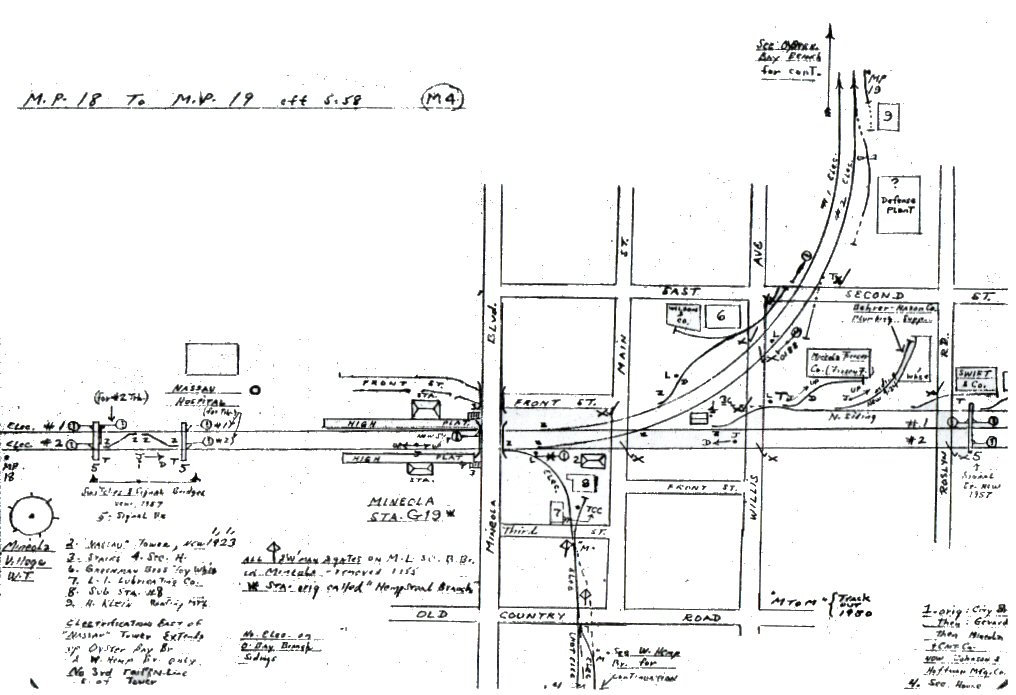
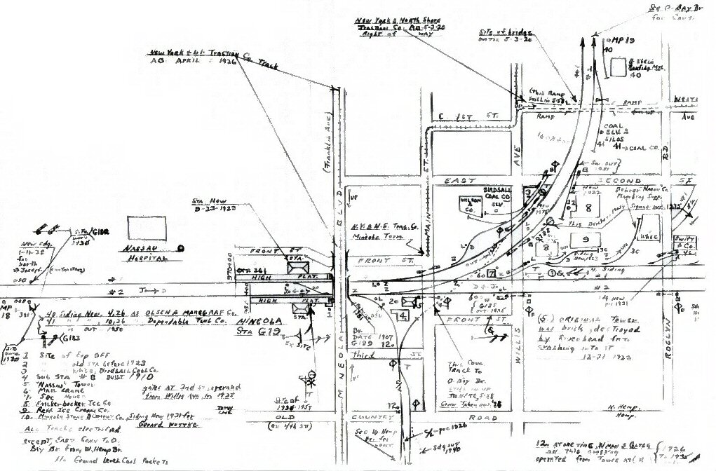
Thanks for those maps.

Where do those NYNS tracks go? I think one I can pick out as the PW line, but what about the others?

  by krispy
 
Nice maps! Thanks for posting that Dave. The last one is what was visible on the old lever machine board, so between '43 and '58 was the last time they signifigantly modified the board. All other changes, such as the removal of the track to the fairgrounds and most of the sidings, were simply painted over, until the strong arm machine was pulled and removed in '97 or '98.

  by Dave Keller
 
Nimby:

Somewhere in the back of my mind, I'm thinking the NY&NS tracks headed as far east as Hicksville, but I don't want to say that as fact without looking at my trolley maps.

Dave Keller

Krispy:

Glad you liked the maps. Did you know that "NASSAU" tower, when it was built to replace the destroyed brick one, retained the call letters of "MT" but on 4/23/37 was renamed "FAIR" due to the proximity of the old Mineola Fair? On 9/18/38 it was renamed "NASSAU."

Mineola trivia!

Dave Keller

  by NIMBYkiller
 
I've read that the trolley did in fact reach Hicksville. I think basically that the N23 and N20 bus lines were former trolley routes, possibly with some minor alterations to the routing.

  by SCB2525
 
What is the viability of rebuilding the ROW between West Hempstead and Country Life Press to make a Hempstead Loop?

  by Sir Ray
 
SCB2525 wrote:What is the viability of rebuilding the ROW between West Hempstead and Country Life Press to make a Hempstead Loop?
Physically, there is no obstruction of the ROW (I have driven by it, walked along it, walked on some parts of it, and transacted business at both the NY Community Bank (their eastern parking lot lies across the ROW) and US Car Wash (the ROW is directly west of their property line). The majority of the ROW is used as a utility corridor right now (you can readily see the H-power polls marching along NorthEast along this ROW through West Hempstead and Hempstead).
From the West Hempstead station, this Utility corridor continues NE across Hempstead Ave., past US Car wash (adjacent to large parking lots), crosses Hempstead Turnpike (near the Hempstead border), passes the nice brick NY Community Bank (formerly Roslyn, I think), continues in that corridor I mentioned above - where this ROW crosses streets (a few) in that area, fencing blocks access to the overgrowth corridor. The 'garden apartment' (may be condos - not sure) complex on the Garden City/Hempstead border does NOT impinge on the ROW. The ROW finally crosses Franklin Ave at an angle at the Garden City border, and used to then curve north (I remember the tracks being partially there in the 1980s) to join the Hempstead Branch less than 100 metres away. I admit I am not sure how the redevelopment of Doubleday by Rock-Rose affected this ROW, if indeed it did.
Now, your problem here is that Hempstead Turnpike and Hempstead Ave are very, very busy at this point, and adding grade crossings there will set off tons of alarm bells, from the State, the County, Hempstead Township, the Village of Hempstead, the FRA, the MTA, the AAA, several small dogs at the NSAL, and a cast of thousands including protesters of the Rahway Valley Reactivation who no longer have anything to do in Jersey...

Say you figured that part out - the next (well, the major problem besides cost) is that the area the ROW goes through is pretty much the wealthiest in Hempstead Village (I think it's called Cathedral Gardens, and it's quite comparable to Garden City north of it - indeed, I find it very difficult to determine the border when driving along Cathedral Ave or St. Paul's Rd without looking at the signs - there is no such problem in Hempstead's grittier side along Clinton or Washington Avenues). I'll leave you to decide how difficult in the current environment re-establishing a long-dormant (meaning no tracks or anything) line in a Wealthy Neighborhood would be...

  by JoeLIRR
 
its not going to be easy,

Hempstead ave and tpk will have to have an el built above them or the tracs sinked and the roads hilled to make it work. an el would look hiddious and be to costly open tunnle would look better but also will be dificuly tho it would help muffle the noise.
remember franklin ave in GC/Hemp border is going to also be extreamly dangorus to go at grade, that will have to be tunnled or bridged also. and that connection would only serve a logic perpose if the CRR is rebuilt because then trains running it would be able to hit the CRR east and every few WM trains would run via atlantic to valley then through HC then back to Jam (on peak only)

  by NIMBYkiller
 
Actually, the ROW is blocked for one block in Mineola between Mineola station and Old Country Rd. Either way though, that'd have to be underground to avoid crossing the main at grade as well as Old Country Rd. It's a very short distance. Should be no problem really.

Franklin Av could probably be crossed at grade. It's already crossed at gradein Garden City near the secondary split.