by CJPat
Ever since the reorganization of RR.Net, I lost the Ferroequinology forum. If its still out there, I apologize for posting this here and the moderator can shift this thread over if he likes.
Last weekend, My wife and I decided to head to the Columbus Farmers market on Rt 206. We headed southwest on Cnty Rt 537 and then in Jobstown, we turned northwest onto Columbus Jobstown Rd to head over to the market. We had travelled this way numerous times before but as I was glancing off at the woods about 20 feet off the left side of the road, I noticed the ground contours seemed to stay pretty straight and level. I noticed this for about a mile and then about 1500 ft before RT 206, the contour hooked towards the road, apparantly crossed over, and seemed to follow a tree line north into the distance.
My wife and I continued on to the market and then returned via the same path so I could get a second look. It did indeed appear to be a rail ROW, albeit heavily overgrown and not much remaining and by what I would guess was atleast 60-70 years since a train probably ran along it. The ROW was wiped out in several places where new development and buildings were.
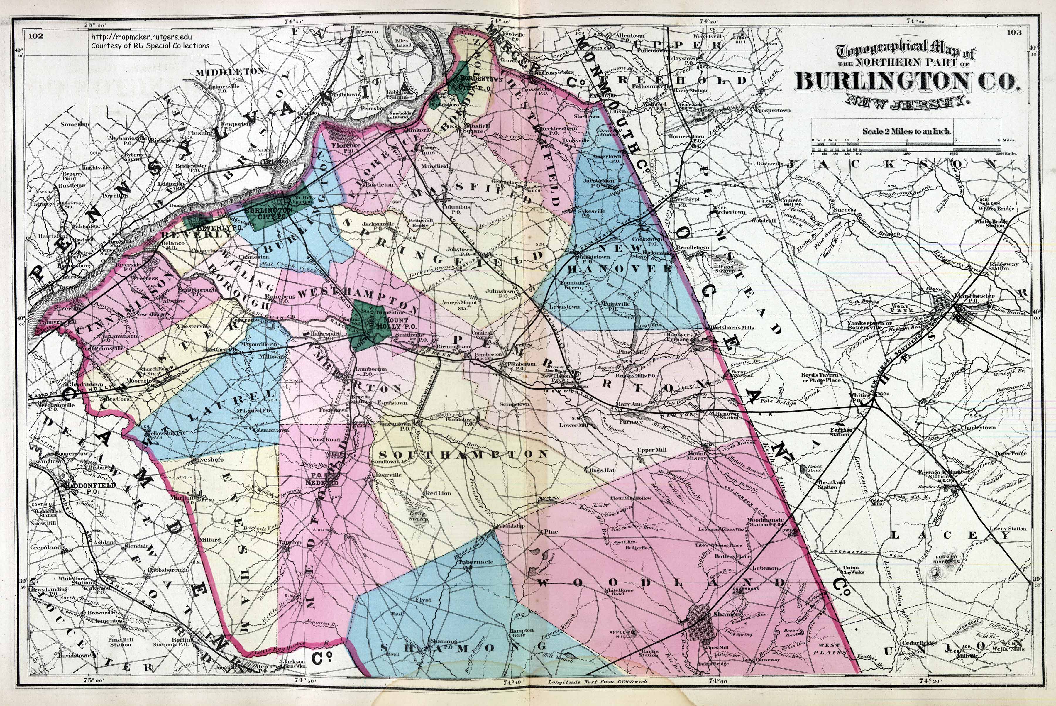
I got home and pulled up the area on Google Earth. Lo and behold, Google verified it was indeed a rail ROW and actually had a line on the map showing where the entire "branch" ran. One of the roads off of Columbus Jobstown Rd was named "Folwell Station Rd". So at one time, it must have seen passenger traffic. Upon deeper map review, the branch appears to run between Roebling on the Delaware River where it used to connect with the main line (Camden and Amboy?), near Newbold Island and drops south easterly to Columbus where it turns more easterly and passes through Jobstown and Lewistown to eventually join the old Pennsy ROW immediately south of FT Dix at the Lewistown Juliustown Rd and Ft Dix Rd intersection. Google shows there was a Wye at that junction.
Google Earth is Great! The ROW would have been difficult to see on standard Aerial photo maps. That fact that Google Earth still shows the entire rail line with a black line on the Satellite photos made looking this up so much easier.
Now, does anyone have any info on this cross-county branch between Ft Dix and Roebling? I do appreciate anyone who could enlighten me to this former line that apparently only served a couple of farming communities or was used as a connector between mainlines. If it provided passenger service at one time, I would bet this rail line originated in the late 1800's.
Last weekend, My wife and I decided to head to the Columbus Farmers market on Rt 206. We headed southwest on Cnty Rt 537 and then in Jobstown, we turned northwest onto Columbus Jobstown Rd to head over to the market. We had travelled this way numerous times before but as I was glancing off at the woods about 20 feet off the left side of the road, I noticed the ground contours seemed to stay pretty straight and level. I noticed this for about a mile and then about 1500 ft before RT 206, the contour hooked towards the road, apparantly crossed over, and seemed to follow a tree line north into the distance.
My wife and I continued on to the market and then returned via the same path so I could get a second look. It did indeed appear to be a rail ROW, albeit heavily overgrown and not much remaining and by what I would guess was atleast 60-70 years since a train probably ran along it. The ROW was wiped out in several places where new development and buildings were.
I got home and pulled up the area on Google Earth. Lo and behold, Google verified it was indeed a rail ROW and actually had a line on the map showing where the entire "branch" ran. One of the roads off of Columbus Jobstown Rd was named "Folwell Station Rd". So at one time, it must have seen passenger traffic. Upon deeper map review, the branch appears to run between Roebling on the Delaware River where it used to connect with the main line (Camden and Amboy?), near Newbold Island and drops south easterly to Columbus where it turns more easterly and passes through Jobstown and Lewistown to eventually join the old Pennsy ROW immediately south of FT Dix at the Lewistown Juliustown Rd and Ft Dix Rd intersection. Google shows there was a Wye at that junction.
Google Earth is Great! The ROW would have been difficult to see on standard Aerial photo maps. That fact that Google Earth still shows the entire rail line with a black line on the Satellite photos made looking this up so much easier.
Now, does anyone have any info on this cross-county branch between Ft Dix and Roebling? I do appreciate anyone who could enlighten me to this former line that apparently only served a couple of farming communities or was used as a connector between mainlines. If it provided passenger service at one time, I would bet this rail line originated in the late 1800's.
