I spent a few hours today driving around the LIPA right-of-way, down the north shore where the line once extended east from the current Port Jefferson terminus. I found it interesting, guessing which roads seemed like they would have been there back before 1938, when the line was active. Some roads seemed to crown, and are about level with the pathway, and others seem to have been filled and graded, and are obviously newer developments. You can figure about which houses could have been old enough to be there back then, it sure seems the Rocky Point village is clustered around the right-of-way, at the lumber yard which the various LIRR History websites say contains the former station building. With a little imagination, you can see the crossbucks, the tattered ties, and the steam locomotives pulling through these neighborhoods. It is funny when you realize that most of the people there are oblivious, don't care, and only know LIPA's lines are there. It was interesting to track this, and I intend to go again another time. It is too bad the line was surrendered back then, I really think it would be busy today, and the idea of todays trains rolling past the backs of these homes really seems like it would be possible. Too bad the NIMBY opposition, and the costs of re-opening the line will prevent it for my lifetime. Just a thought...
Railroad Forums
Moderator: Liquidcamphor
Yeah, walking old ROWs is really fun. You should come with us when we walk the CRRLI from Merrick Av to Levittown(I'm not doing that whole thing in one walk).
We as rail fans and historians, should mark these places and make replica cross bucks of the time saying under them instead of "exempt" but rather former "____ROW" making it obvious to the NIMBYS and the people of current long island where these places once were, and making the history of these Row’s come alive.
As railroad historians we all should join forces and welcome the LIRR and there friend/foe Newsday and news 12 on making these places known and there modern places marked. It will get the idea of "what was" out there to the public that has "forgotten" or "never knew" existed in those areas.
this might be a good project for the chapters and RMLI to get involved with also.
lets think of the positive things that can and will come from it.
I lived in Miller Place in the early 90's and did alot of exploring around the old ROW. There was an old stone overpass still standing back then. I can't remember over which street it was but I believe it was east of Rocky Point. Anyone know which street it was and if it's still standing?
Don't strain your brain, paint a train.....
The sad thing about Wading River is that the line's needed today...but it was abandoned what, 75 years ago?
In an ideal world, you'd have 3rd rail out to Port Jeff and a DMU shuttle between Wading River and Port Jeff/Jamacia (off peak/peak). Given a DMU's quieter than a bus and a lot faster than a DE/DM (anyone here ever ride the RiverLine in NJ? It's like a somewhat sluggish LRV), it'd make sense.
But, the trouble is, you can't really claim that the train line was there first - yes, it was, but for all intents and purposes, it wasn't.
Who owns the ROW anyway? It could get into a LOT of sticky legal issues to reactivate it anyway...
The sad thing about Wading River is that the line's needed today...but it was abandoned what, 75 years ago?LIRR was the railorad before its time.
* LIRR was built for todays needed service but it was all cut back and riped out before it's future potentical was seen*
TO prove to people what was there, we as fans, because u don't think the LIRR will, so WE need to trace the ROW and put bullitens along it. stating its orgians, photographs of it showing people what they really had there, all evidance that the trian came first. WE need to do it cause NO ONE else will.
its your past and your possibly re opening that lays all in our hands now, if we dont act it will never happen wadeing river has 90% chance of trains again compared to the GCS-Binterlocking being re installed. If we as LIRR rail fans get this public and publisise it enough, then and only then will a greater intrest appeal.
wheres "Rails to Trails"
Clean off the ROW make it a walking/bikeing path, and along that path lay some rail and tie's ueing them as curbs in a way, and use rail to suppoet a mast that will hold a discription&location table on it. for the hell of it, put W posts and RRxing signs of the era there too...
Make the ROW tell the Story. Make the Public walk the Row and Make them think how it would be if they can ride a train on that ROW. then you will see a limited extention, to maby 1 stop east of PJ. then slowly further East.
It will happen but We need to make it a trail and We need to work as a team to show and bring back what once was, yo its not happenign over night for all i know this can take a year or 50 years, but if we listen to my plan and try to build something out of it instead of tare it apart. i bet we will get something from it, and both things will be plusses.
A pedestrain/bikeing path??? thats a GOOD thing
A extension from PJ-points east in due time?? Thats a GOOD thing
Its a WIN WIN situation guys and girls, lets do it, the scouts can have the transformation of the ROW as there egle scout project ect..
An interesting piece of trivia about the stone overpasses:
There was at least one other stone structure east of Port Jeff that was similar to the one remaining today at Woodville Road, Shoreham: The one over Rocky Point Road.
I have photos of it being dismantled in 1939. The massive, dark brown stones were carted north to the beach and were used as a retaining wall on the west side of the roadway that went down to the water, just a short distance before you hit the actual beach. I believe it was Hallock Landing Road, which was a continuation of Rocky Point Road over which the trestle carried the LIRR tracks.
For all I know, the stones may still be there today. I saw them there back in the early 1970s. Something for someone to hunt down!
Dave Keller
my only bit of confusion was the approximate point of termination. Maybe one of our historians on here knows about the closest current intersection, to the end of the ghost line out there. thanks, i appreciate the help.
And confusion there should be! There was a bit of mix-up due to changes in the end-of-track at the end.
Please read my description of the end of the line from my "LIRR Station History" listing:
WADING RIVER
BUILT: 1895, REMODELED TO TWO STOREY: 1906.
AGENCY CLOSED: c. 1933.
STATION FACILITIES RElOCATED 1 MILE WEST OF FORMER LOCATION TO RANDALL ROAD: 1/18/38 (MILLER FAMILY RECLAIMED THEIR PROPERTY FROM THE RIVERHEAD TOWN LINE EAST TO END OF TRACK).
WOODEN DEPOT RAZED SOMETIME AFTER AND LUMBER USED TO BUILD STORE NORTH OF STATION SITE.
LAST REVENUE TRAIN: 10/9/38.
RELOCATED STATION OUT OF SVC: 3/29/39 WITH BRANCH ABANDONMENT AND TRACK CUT-BACK.
GENERAL ORDER #1006C, EFFECTIVE 3/29/39:
SINGLE TRACK FROM A POINT 1,550’ EAST OF EAST LEG OF WYE, PORT
JEFFERSON STATION TO WADING RIVER STATION OUT OF SERVICE.
Confusion solved!
Dave Keller
cool to bad atleast a portion could not be re build like to Agway which would be a nice for freight.
The branch is a must be re built and the demand is clearly there, I have posted several ways in previous posts that can be the foundation to its restoration since 9.9/10 people there don't have the slightest idea as to what that ROW was from. re read my suggestions, and make a plan or build off them, my ideas are only rough plans needing to be worked on and improved with the help of my fellow rail fans.
the demand is clearly there to rebuild the line, even if they just go to the first station east of Port Jeff one year then the next they go 2 more stations till they reach Wadeing River.
the demand is clearly there to rebuild the line, even if they just go to the first station east of Port Jeff one year then the next they go 2 more stations till they reach Wadeing River.
Another interesting point of trivia concerning end-of-track:
While the end of track was on the west side of Wading River-Manor Road, the OFFICIAL end of track was actually further east, as a siding branched off the main near the depot, passed the main's end-of track, crossed Wading River-Manor Road and headed east a short way beyond to service a customer located there.
Technically, the LIRR's end of track, prior to the relocation of Jan, 1938 was further east than the main!!
Some days gone by:
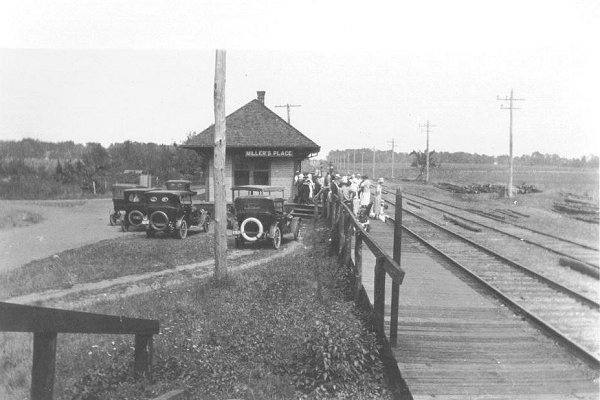
Miller's Place - 1915
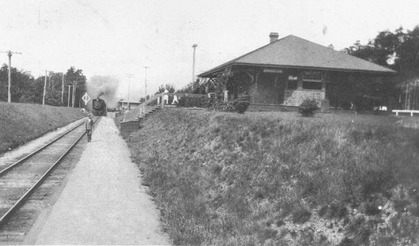
Shoreham - 1912
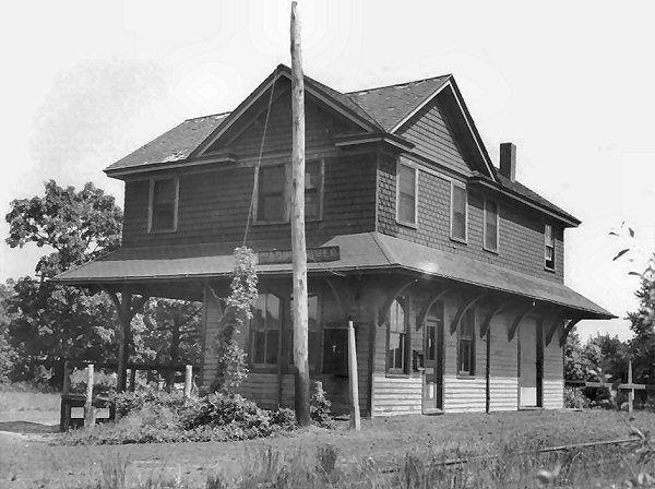
Wading River - 1937
Dave Keller
While the end of track was on the west side of Wading River-Manor Road, the OFFICIAL end of track was actually further east, as a siding branched off the main near the depot, passed the main's end-of track, crossed Wading River-Manor Road and headed east a short way beyond to service a customer located there.
Technically, the LIRR's end of track, prior to the relocation of Jan, 1938 was further east than the main!!
Some days gone by:
Miller's Place - 1915
Shoreham - 1912
Wading River - 1937
Dave Keller