Railroad Forums 

  • Old Map of commuter rail?

  • Discussion relating to commuter rail, light rail, and subway operations of the MBTA.
Discussion relating to commuter rail, light rail, and subway operations of the MBTA.

Moderators: sery2831, CRail

 #932496  by kingcheese26
 
Hi everyone,

I've been wondering about the old Arlington-Lexington-Bedford branch of the Commuter Rail. I saw a map of it a while back, and I'm just wondering if anyone has an old map of the Commuter Rail from when this line ran.

Thanks,

Ezra
 #932567  by F-line to Dudley via Park
 
Got lucky on Flickr...never seen one from this era before.

Image

Says it's from 1976, but probably dates to Spring/Summer '75 after South Acton-Ayer service ended (3/1/75) but before Framingham-Worcester service ended (10/27/75). Also still has the 3 Andover stops on the Haverhill Line (closed 11/75) and Malden on the Reading Line (closed 12/27/75).
 #932624  by bingdude
 
jamesinclair wrote:There was service beyond worcester?
Amtrak ran a couple of daily trains to Springfield Until about 1974.

Also, this map shows Riverside as a stop on the Framingham line. That stopped happening in 1975.
 #932653  by BostonUrbEx
 
Interesting, the oldest map in this style that I've seen is probably the next generation. It has the Lexington branch end at Lexington, and a split at Lawrence to Methuen.
 #932657  by TomNelligan
 
Interesting, the oldest map in this style that I've seen is probably the next generation. It has the Lexington branch end at Lexington, and a split at Lawrence to Methuen.
Lawrence-Methuen was a proposed extension that never materialized, but it appeared on maps for quite a while. However that Lexington Branch graphic would be interesting since the one weekday train (just a single RDC car, BTW) went all the way to Bedford until the end of service. I don't remember any proposal for a cutback from Bedford to Lexington, but maybe that was discussed at the T before the abrupt end of the whole line.
Interesting to note that the Western Route from Ballardvale to Reading was freight only.
Yes, the one Haverhill train at the time ran via the Wildcat, not via Reading.
 #932695  by boulderdashcci
 
Are there any remnants of East Foxboro station? Looked on Bing and Google and didn't see anything, nor have I ever seen anything from the train. What street was it on/near?
 #932723  by BostonUrbEx
 
TomNelligan wrote:
Interesting, the oldest map in this style that I've seen is probably the next generation. It has the Lexington branch end at Lexington, and a split at Lawrence to Methuen.
Lawrence-Methuen was a proposed extension that never materialized, but it appeared on maps for quite a while. However that Lexington Branch graphic would be interesting since the one weekday train (just a single RDC car, BTW) went all the way to Bedford until the end of service. I don't remember any proposal for a cutback from Bedford to Lexington, but maybe that was discussed at the T before the abrupt end of the whole line.

Hmm, I'm almost positive there was one which had shown the end being Lexington.


Anyways: here's one from 1980 showing Methuen and Rt 213:

Image

I never knew that the Methuen branch never happened, I'm rather surprised it didn't happen... Is there a particular reason why it didn't?

I like how this map also has Nashua, Manchester, and Concord. But why is Malden not shown? Surely the trains would have to pass through Malden, so what happened?
 #932752  by F-line to Dudley via Park
 
BostonUrbEx wrote:
TomNelligan wrote:
Interesting, the oldest map in this style that I've seen is probably the next generation. It has the Lexington branch end at Lexington, and a split at Lawrence to Methuen.
Lawrence-Methuen was a proposed extension that never materialized, but it appeared on maps for quite a while. However that Lexington Branch graphic would be interesting since the one weekday train (just a single RDC car, BTW) went all the way to Bedford until the end of service. I don't remember any proposal for a cutback from Bedford to Lexington, but maybe that was discussed at the T before the abrupt end of the whole line.

Hmm, I'm almost positive there was one which had shown the end being Lexington.


Anyways: here's one from 1980 showing Methuen and Rt 213:

Image

I never knew that the Methuen branch never happened, I'm rather surprised it didn't happen... Is there a particular reason why it didn't?

I like how this map also has Nashua, Manchester, and Concord. But why is Malden not shown? Surely the trains would have to pass through Malden, so what happened?
1981 had a horrible budget crunch that shut down parts of the system, by far the most acute in the T's history. They couldn't continue the Concord service that had started on a trial in 1980, so that went by the boards. The startup of Methuen and the Rosemont extension of the Haverhill line (basically same as Plaistow but stopping just before the state line instead of after) had to get dropped. The Woburn branch's track conditions deteriorated so badly with no money to repair it that it was abandoned. Providence Line was cut back to Attleboro. There was no Sunday service to Ipswich. Numerous intermediate stops were temporarily closed for months to save on crews. And the subway got hit hard with weekend closures of the Blue Line and Orange Line past Orient Heights and Wellington, and temporary station closures affecting Bowdoin, Chinatown, Boylston, and Symphony.


Methuen would be a great addition to the map today, or even poking the mile across the border on the abandoned tracks and terminating at a Rockingham Park park-and-ride stop. Huge amount of I-93 relief there. Unfortunately biggest cost blocker there is rehab of the Merrimack River and canal bridges in Lawrence, which are OK for the couple freights per week that use the line but not nearly up to snuff for passenger service. Lot of expense to sink into a short-turn line. I think eventually this route's gonna make too much sense not to do, but we're not there yet. Methuen's got a nifty little train station on the line very well-preserved.
 #932795  by gunsanplanes
 
I'd love to see more trains coming up towards Salem, but that whole M&L stretch is destined to be railtrail.
Methuen is jumping in on it.

"Construction on Methuen rail trail could start this summer"

http://www.eagletribune.com/local/x1386 ... his-summer

Salem is paving the 1st mile of their railtrail this summer, starting at the windham town line.
Windham is paving from where they left off to the salem line.
Derry is paving from where they left off to the windham town line, also this summer.
 #932834  by F-line to Dudley via Park
 
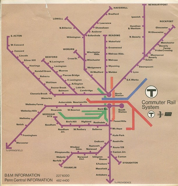
gunsanplanes wrote:I'd love to see more trains coming up towards Salem, but that whole M&L stretch is destined to be railtrail.
Methuen is jumping in on it.

"Construction on Methuen rail trail could start this summer"

http://www.eagletribune.com/local/x1386 ... his-summer

Salem is paving the 1st mile of their railtrail this summer, starting at the windham town line.
Windham is paving from where they left off to the salem line.
Derry is paving from where they left off to the windham town line, also this summer.
Salem portion of the trail north of Range Rd. has been in the works for years, but that's where it terminates. Everything south of there including Rockingham Park to the border isn't in the plan. Or at least won't be until some future Phase II that doesn't formally exist gets drawn up. But that's low on the pecking order for NH's trails priority list.


The Methuen filings need some serious asterisks attached. That one's being pushed by a blog-backed lobby, much like the Needham clowns who are trying to take the Millis line through a PR hot air end-run. This one is considerably more legit than that, as they did work the system with the proper filings. But the Eagle Tribune is getting most of their quotes from the trail bloggers. They're jumping the gun a little bit.

The T has a standard agreement for rail trails (there's a scan of the Newburyport one online, but can't locate the URL). They're a non-binding prelim step where a lot of conditions have to be met before the trail happens. The T has to get 60 days' notice to review and approve the design plans for the property, and the trail/town has to document good-faith effort at formally pursuing funding. Until they do both of those, the agreement isn't in effect. And there is a time limit in the general statutes on funding pursuit (i.e. filing formal grant requests), although as long as they're trying for it they're in compliance whether they get it or not. These types of agreements are more common than you might think because all it really takes is intent, formal filings, backing of the town, and a line owner who can't think of a better thing to do with the OOS line. But a majority of these nationwide don't even end up proceeding to the point where they get executed as real leases because of the whole getting-it-together on planning and funding steps. It's more an "OK, I'm willing to entertain this if you guys are serious" filing. And if they do want to repossess the line for any transit purpose, it's 2 years' notice to terminate the lease...no questions asked, no protests lodged (as far as tearing up the lease is concerned...restoration and/or compensating the trail's a whole other ball of wax).

Problem with Methuen is that it's pretty much all-volunteer. And their only source of planning for this is to have Iron Horse Preservation, the scrap-metal scam artists who masquerade as rail-trail Johnny Appleseeds, come in and do their usual crap job hauling away the ROW hardware, do a quickie raking-over of the ballast without grading down any surface that withstands any rain without turning into puddle/washout city, and then blow town to get rich off re-selling the scrap. They show up with the exact same--down to the last word--sales pitch parroted by some mayor or alderman to the local paper. Every time like clockwork. It's their whole playbook. The trail lobby has no choice but to put all their chips on the outfit that can claim to do the work for "free" and lather up the pols while they're at it, because they're either an all-volunteer trail group or the town that wants the trail is winging it on its own without access to funding. That's the scam. Iron Horse leaves a low-quality trail behind for the "free" job, and in some cases the town or trail organization gets burned by it when the trail left behind has safety, environmental, or maintenance issues that jeopardize the lease (more a risk when it's a private RR leasing than a state agency). The fact that they're making a big to-do about getting volunteers to pick up trash on the ROW as if that's going to get construction started in a few months should be a pretty clear sign that this is a pretty threadbare effort on the means.

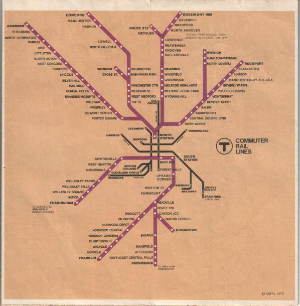
I don't know how willing the T is going to be to put full faith in "but Iron Horse said so!" in lieu of a well-thought out funding or design plan. Iron Horse did a generally lousy and careless job on the Danvers rail trail, but that one did at least have formal plans, multi-municipality cooperation, and sources of state funding behind it for the T to approve it and set the lease into effect. Methuen doesn't have any of that, just an enthusiastic lobby and town pols who vocally support the lobby. So unless they can get a funding grant, a well-designed plan, and proof that they can actually maintain the thing after it's built, why would the T willingly donate 2 miles of scrap metal it already owns for usage the lessee has no wherewithal to support? That's the very definition of being taken for a scam. The T is not going to approve plans that don't serve its interests. And, yes, having a functional-enough trail to keep the abutters from encroaching the ROW to death does sort of serve their interests. But that's all the more reason that they should only approve a design that isn't a one-and-done hack and only give approval where there's viable funding sought. The NH part of the M&L trail is a fully gov't-funded job. So is the Saugus Bike to the Sea and (poor design and all) the Danvers-Lynnfield trail who were the other two parties given these 99-year leases on the same day. They've only been approved to be approved. Nothing is ever that easy.


In their support, I would say Methuen Rail Trail is playing by the rules. And they got rewarded with the chance to execute a lease because they played by the rules, and because as a public agency the T is *somewhat* compelled to allow use of its ROW's for public service (much as I'd like to see them put a "NIMBY's will be shot dead" sign next to every stretch of rusted track). Now Methuen has a chance to put their best foot forward for the next approval step. All of this is a HELL of a lot more legit than what those Needham-Medfield poseurs are pulling goading gullible Dover and Medfield pols into town council votes, holding ribbon-cutting ceremonies on an active freight line in violation of trespassing laws, and trotting out Iron Horse as saviors in the local Patch rag saying "so is Tuesday good for you guys with the scrap trucks?"...all without a single formal filing document or involvement of a single MBTA official. On an active rail line.


I still think Methuen needs to be a CR line sooner than later for I-93 border relief. It's gonna become a fully in-district problem in a decade or two, and it's not like MassHighway can do any more interstate widening anywhere at all with how maxed-out the roads are. This would be way cheaper than doing something with 93, and that's the value in keeping it as a long-term CR hold. NH is steering its M&L trail at the state level to keep the towns from doing divide-and-conquer on the ROW. I will be pissed off if the T allows its portion to go trail and doesn't put some stipulation teeth in it about the what-if's. It did so in Newburyport when it told them their downtown path can't touch the Merrimack Bridge approache, so if they ever wanted to restore the Eastern Route they had wiggle room to broker some rail-with-trail peace with the town and not have their rail bridge permanently blocked by some scenic fishing pier. Stipulation that the M&L trail be landscaped and kept well enough clear that they could feasibly do a rail-with-trail in the future would do the trick legalese-wise. The usual Iron Horse scorched-earth job isn't even gonna brush-cut well enough much less do the culvert and landscaping work necessary to re-establish property lines.
 #932853  by gunsanplanes
 
I know the mods are tight on getting off topic, so I'll try to let this rest with a couple of thoughts.

The Salem section of trail is to get paved to the end of rockingham rd. near where granite state potato chips were.

I also agree that it'd be sweet to get commuter rail to a park and ride by the race track, and, man, does the track have a ton of acreage sitting idle.

And,lastly, I just can't fathom the headache of trail users vs. cars at all those crossings south of rockingham rd.

I grew up on rockingham rd.
Unkowingly, as a kid, trespassed/walked the tracks all the time. Chatted with the train crew at grossmans. Good natured crew put up with incessant questions, showing me how to couple hoses, pull coupler releases.
Got a short ride or two in the cab....damn fun being a kid in the 70's.
Sucks to watch it all go away over time.

And in all honesty, I've allowed myself to get fat over the years. I'm biking my butt off to do something about it though.
And while I'll bike the windham section, mostly due to time constraints, I most enjoy non-paved trails.
What sections of the WN&P I can get on that prohibits 4 wheelers, and any of the manchester to portsmouth branch.
 #933309  by A320
 
I was surprised to see Newburyport on the 1976 map.

Was there service up to there in 1976, or was it just being proposed? If so, when did that service get cut back to Ipswich, as is shown on the 1980 map? I had always assumed that Ipswich became the end of the line when all passenger service to Portsmouth ended in 1965.

Also, where would the Newburyport station have been in 1976? And was there no stop at Rowley?

Thanks for finding those maps.