charding
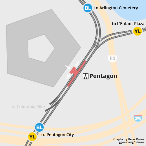
...here was one line that was not built...from the Pentagon down Columbia Pike toward Bailey’s Crossroad...in fact, if you have a keen eye as you go from the Pentagon to Pentagon City just as you clear the station, you’ll notice what appears to be a turnout...it is...was supposed to be the start of the Columbia Pike line...
The turnout bell mouth for outbound track N2 is clearly visible from the south end of the lower level platform. The knock out is about 300' from the of the end the platform and 30' to the right. The turnout bell mouth for inbound track N1 has tunnel that pass over outbound track C2 about 300' beyond the bell mouth.
 Graphic Peter Dovak Greater Greater Washington
WMATA built future provisions for extensions at the end of
every route as well as the two future branches. Though not all are on the map they are all there. If you look closely at the aerial photographs at google maps you can see were the turnouts and or flyovers would be at Shady Grove, Greenbelt and Branch Avenue, Largo and Glenmont have junction turnout provisions that were built. The turnout bell mouth and knockout at Glenmont for outbound track B1 is clearly clearly visible from the north end of the platform.
Not all provision built for the Silver line were used, The junction turnouts provision were under Haycock Road, The junction ended up being built at Great Falls Street adjacent to the substation, The column foundations for the VA I-66 flyover were used.
John in the sand box of Maryland's eastern shore.