Railroad Forums 

  • History of the Allentown, PA train service.

  • Discussion related to New Jersey Transit rail and light rail operations.
Discussion related to New Jersey Transit rail and light rail operations.

Moderators: lensovet, Kaback9, nick11a

 #1475763  by braves
 
I would like to know more about the history of the Allentown, PA train service, I know that Lehigh Valley Line stopped running there in 1961 follow by Central New Jersey in 1967.

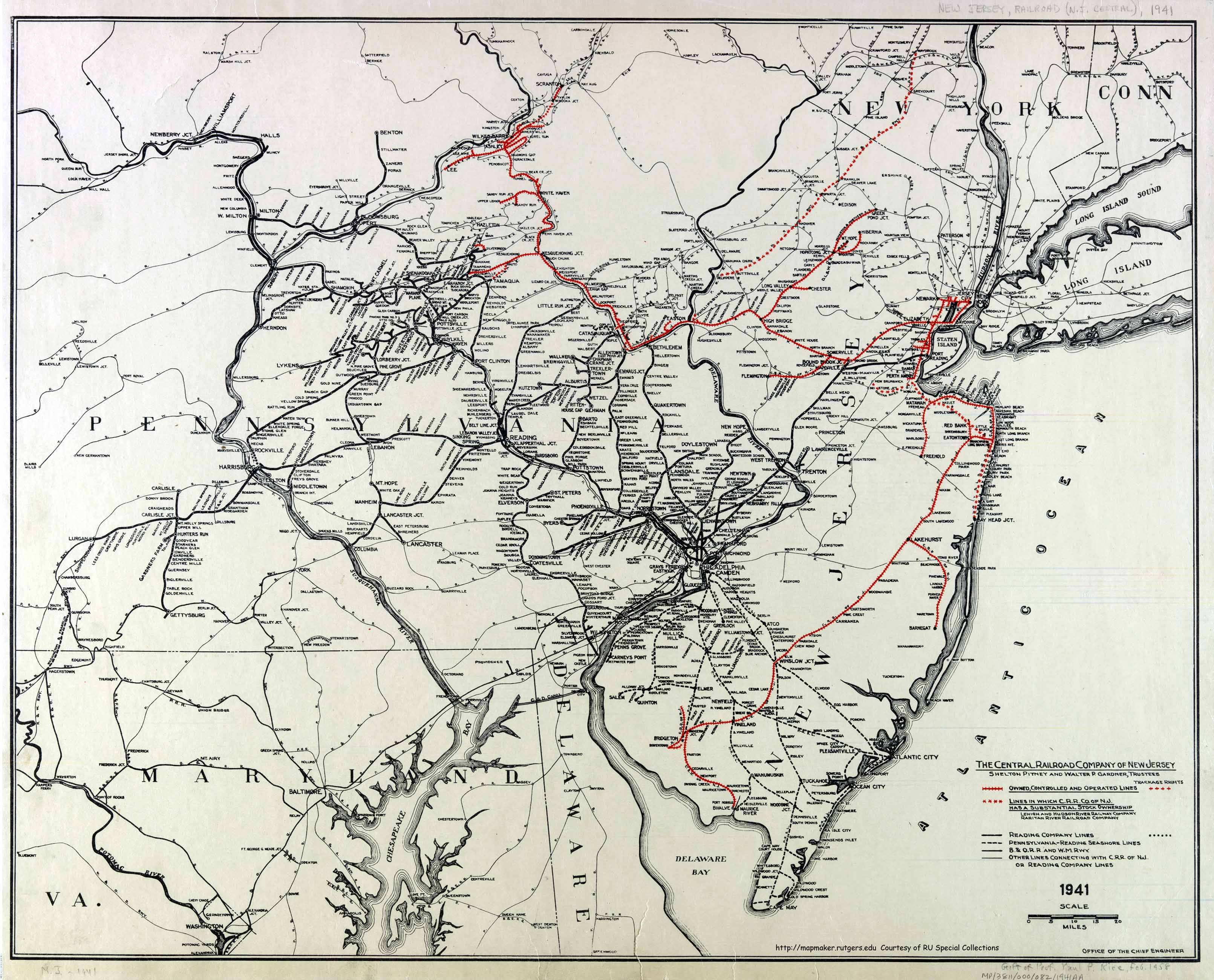
What route did the Lehigh Valley Line take in both New Jersey & Pennsylvania & where did it operate between prior to it's closure in 1961 & since I know what route the Central New Jersey took in New Jersey prior to it's closure in 1967 which is now NJ Transit Raritan Valley Line between High Bridge & Cranford & between High Bridge & Phillipsburg (discontinued past HIigh Bridge in 1983) but what route did this line take in Pennsylvania, did it follow the same path (using the same tracks) as the Lehigh Valley Line or no & what route again in Pennsylvania did it take after the Lehigh Valley stopped running there in 1961.

Where did the Lehigh Valley operate between.

I also understand that I-78 servered part of the Central New Jersey line near Phillipsburg, my question is this segment where I-78 servered gone for good & if anyone has pictures of it, can someone post them up.

If rail service is restored back to Allentown, PA someday, can it still use the old Central New Jersey or a different path (if the section was severed by I-78).

If anyone knows of books about the Central New Jersey to Allentown, PA prior to it's closure in 1967, list the book(s) on this
 #1475768  by Ken W2KB
 
With respect to the Jersey Central in Pennsylvania, its mainline went from Jersey City to Scranton. It did not use the more or less parallel in PA Lehigh Valley tracks. Eventually (around 1972 I think) the railroads combined the LV and CNJ tracks in PA using whichever railroad's tracks made economic sense and abandoning the other, essentially alternating along the route.

As to I-78, a bridge over the highway would have to be built, as well as another on a County road, if service were ever to return. It is my understanding that the entire abandoned right of way of the CNJ in NJ is intact and owned by the State.

If service were to be returned to the west it would likely use the Lehigh Line from about Bloomsbury to Philipsburg if Norfolk Southern, which has publicly stated that it would not permit it, could be convinced to allow it. What is most likely and economically most feasible is to extend service on the out of service former CNJ track (which is still present) from High Bridge to Exit 7 on I-78 with a park and ride built there at the existing highway interchange. Plenty of open land there and it is west of Jugtown Mountain which grade is problematic for vehicles on I-78 especially in inclement weather.

There are many CNJ maps online. Here is one: https://mapmaker.rutgers.edu/HISTORICAL ... R_1941.jpg
 #1476087  by kilroy
 
For photos, there are the VCNJ Morning Sun books. There is also a book Railroads to Allentown (or something like that). I think it was put out by The Railroad Press or maybe a local historical society. I have the book at home.
 #1476231  by pumpers
 
Interesting, that map (1941) shows the CNJ had partial ownership of the Lehigh and Hudson River. Never knew that. Makes sense though, I think the LHR had rights to Bethlehem, so they could take CNJ traffic from the West up to Maybrook for NewEngland.
Were they both part of the Alphabet Route?
 #1476306  by ExCon90
 
I'm pretty sure that's how the alphabet route got to New England. Something that always concerned me a little was that there was no direct "steam railroad" service to Allentown from Philadelphia other than the through cars for Buffalo over the LV. The fastest service, with the best frequency, was Lehigh Valley Transit to 69th Street.
 #1476317  by Backshophoss
 
Believe after NJT retreated to Highbridge,most of the ROW was lost to I-78's sweeping curves to the toll bridge to Pa.
CR abandoned most of the "redundant" CNJ(CRPA) trackage turning any remains to "Industry track" that remained after the CNJ retreated
from PA
 #1476530  by Ken W2KB
 
Backshophoss wrote:Believe after NJT retreated to Highbridge,most of the ROW was lost to I-78's sweeping curves to the toll bridge to Pa.
CR abandoned most of the "redundant" CNJ(CRPA) trackage turning any remains to "Industry track" that remained after the CNJ retreated
from PA
None of the former CNJ right of way was lost to I-78. The only missing portion due to I-78 is the approximately 250 foot width of I-78 where I-78 crosses the right of way at slightly less than a 90 degree angle. Look at this from Google Maps. The right of way is shown from the right edge, and curving northwest just south of the pond. The bottom of the map right of way crossing I-78 is the active Lehigh Line, former LV. https://www.google.com/maps/@40.6580358 ... 223,17.25z The entire CNJ right of way is traceable on Google Maps by looking carefully.