As a former resident of Astoria, 1954-1976, I have an interest in the Queensboro Plaza station, especially during the era (1920s thru 1940s) of its most complex operating configuration.
I recently came across this photo at the Greater Astoria Historical Society website: http://astoriahistory.smugmug.com/galle ... &k=kNxbH37
The view is looking west towards the station, probably taken from the roof of a building at Northern Boulevard (Route 25A) and 41st Avenue. The 2 tracks closest to the camera at the higher elevation are the existing Astoria line. Below, at a lower elevation, you can see the (now demolished) tracks that linked the Astoria line to the (now demolished) northernmost upper and lower level tracks in the BMT side of the Queensboro Plaza station. The photo appears to show 3 tracks (now removed) at a lower elevation curving towards the (now removed) BMT north side of the Queensboro Plaza station, as well as the 2 tracks (which remain today) at a higher elevation curving towards the IRT south side of the Queensboro Plaza station, which remains today.
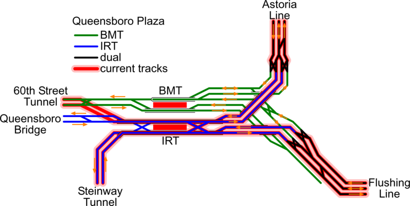
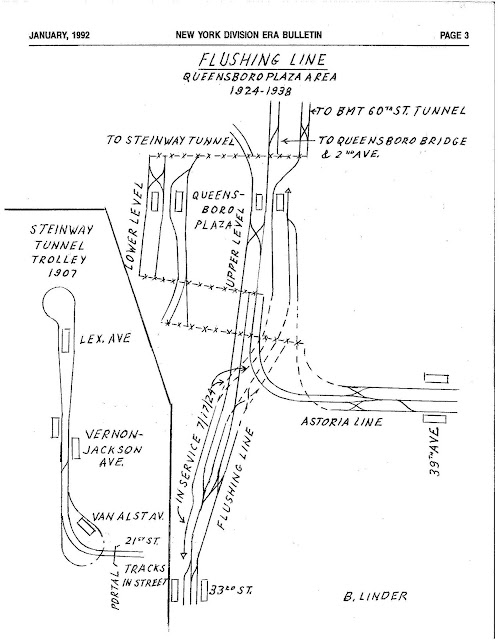
Here are two diagrams of the historical track configuration in the 1924-1942 era:
http://upload.wikimedia.org/wikipedia/c ... _Plaza.png
http://1.bp.blogspot.com/-uUxpyuexr9E/U ... sboro1.jpg
Based on these track diagrams, I have always thought I understood the flow of all trains in and out of the station on all lines/tracks, and that there were only 2 lower elevation tracks that curved between the Astoria line and the BMT north side of the Queensboro Plaza station. One track connected the northernmost upper level BMT track in the station to the Astoria line, and it was used by shuttle trains from Queensboro Plaza to Ditmars Blvd; the other track connected the Astoria line to the northernmost lower level BMT track in the station, and it was used by Astoria line shuttle trains from Ditmars Blvd to Queensboro Plaza.
Question: Can anyone resolve the disparity of 3 tracks in the photo versus 2 tracks in the track diagrams?
I recently came across this photo at the Greater Astoria Historical Society website: http://astoriahistory.smugmug.com/galle ... &k=kNxbH37
The view is looking west towards the station, probably taken from the roof of a building at Northern Boulevard (Route 25A) and 41st Avenue. The 2 tracks closest to the camera at the higher elevation are the existing Astoria line. Below, at a lower elevation, you can see the (now demolished) tracks that linked the Astoria line to the (now demolished) northernmost upper and lower level tracks in the BMT side of the Queensboro Plaza station. The photo appears to show 3 tracks (now removed) at a lower elevation curving towards the (now removed) BMT north side of the Queensboro Plaza station, as well as the 2 tracks (which remain today) at a higher elevation curving towards the IRT south side of the Queensboro Plaza station, which remains today.
Here are two diagrams of the historical track configuration in the 1924-1942 era:
http://upload.wikimedia.org/wikipedia/c ... _Plaza.png
http://1.bp.blogspot.com/-uUxpyuexr9E/U ... sboro1.jpg
Based on these track diagrams, I have always thought I understood the flow of all trains in and out of the station on all lines/tracks, and that there were only 2 lower elevation tracks that curved between the Astoria line and the BMT north side of the Queensboro Plaza station. One track connected the northernmost upper level BMT track in the station to the Astoria line, and it was used by shuttle trains from Queensboro Plaza to Ditmars Blvd; the other track connected the Astoria line to the northernmost lower level BMT track in the station, and it was used by Astoria line shuttle trains from Ditmars Blvd to Queensboro Plaza.
Question: Can anyone resolve the disparity of 3 tracks in the photo versus 2 tracks in the track diagrams?