• Southcoast Rail

  • Discussion relating to commuter rail, light rail, and subway operations of the MBTA.
Discussion relating to commuter rail, light rail, and subway operations of the MBTA.

Moderators: sery2831, CRail

  by rr_explorer
 
Quote from: midnight_ride

Political reality check: If anyone thinks this announcement is actually about building a new commuter rail branch, I've got a bridge to Brooklyn I'd like to sell you. :wink:[/quote]

It is also for politically connected:
-construction firms
-engineering firms
-public relations firms
-lawyers, to fight the inevitable enviro-nazis
-people with real estate holdings that will be worth more $$

Also, more state jobs for 'friends' and relatives .
  by theinsider
 
mental757 wrote:...
The junction near Silver City is Copley Junction - correct??
...
It is actually called Cotley Junction. Not sure if it is still, but at one time the abbrv, was COT for use on Form D's etc.

  by Robert Paniagua
 
ceo wrote:Not quite. A wye is a track configuration shaped like a Y, hence the name. In this case the Attleboro Secondary branch is only accessible to trains traveling northbound on the NEC (because it was originally built for trains traveling between NYC and the Cape). A train from Boston would have to pull past the junction and then reverse onto the branch. Making the intersection into a wye, with links in both directions from the branch to the NEC, would allow southbound trains to proceed directly onto the branch.
That's what I meant to say in my last message, about the wye being "Y", but you must have thoguh I meant a diamond. Sorry 'bout that. As for the Attloeboro Secondary that cuts through the Barrowsville section of Norton and to Taunton, which used to be the Cape Codder train's route, should be converted into a Y so that Southbound trains from Boston can cut though without changing ends at Attleborough. That would mean some emminent domain, and bulldozing of several business that occupy the new bridge to get from the Attleboro Sec to the NEC North, and then put in the new bridge. I'd have to download an aerial image and photoshop it with the new bridge to show what I mean.

  by MBTA3247
 
The system maps in several offices at BET show the proposed FR/NB line being an extension of the Stoughton line through Easton and Taunton. I can't remember offhand if it then went through Dighton or Myricks Swamp en route to FR.
  by GP40MC1118
 
The so-called Attleboro Bypass connection was proposed when the Weld administration was in power. It would come off the Taunton/Attleboro
mainline around Chartley Ponds along the power line right of way through Norton to the Amtrak NEC mainline near "Lazy Lady Farm" (or at least that was a name bandied about back then).

This went down in flames due to fierce opposition from CCATTS, based in
Norton. And Taunton was opposed because it would have brought trains through downtown and "cutting the city in half". Duh...

IMHO, the only way to go is via Stoughton because thats where all the
ridership is.

Trackago through Taunton - the Stoughton Route would use the EOTC owned, BCLR operated Dean St Industrial Track...continuing beyond
Winter St (Ventura Grain) to Raynham Junction.

If you were to use the Raynham Jct to Whittenton Jct abandoned mainline, you would have to go through downtown Taunton, which they probably wouldn't go for.

Ironically, the computer dispatching display for NB/FR exists and is designed for the Attleboro Bypass route. Oh well.

Dave

  by MBTA F40PH-2C 1050
 
computer dispatching? i assume u mean for the train dispatchers? y would they have designed something so early?

  by rhodiecub2
 
MBTA F40PH-2C 1050 wrote:computer dispatching? i assume u mean for the train dispatchers? y would they have designed something so early?
especially when it might not even happen

  by theinsider
 
MBTA F40PH-2C 1050 wrote:computer dispatching? i assume u mean for the train dispatchers? y would they have designed something so early?
Probably much more cheaper to do it then then add it in later.
  by GP40MC1118
 
It was part of the same system purchased for the Northside
office years ago that replaced the GRS Traffic Master system.
Its a display of the projected track arrangement only, which is
about 50% incorrect (like not triple track between Cotely and
Weir Jct, wrong location for the Fall River layover, etc.). And
its not complete either.

Still its kind of neat seeing what might have been:

From north to south it shows:

Single track to passing siding between CRANES and TREMONT.
Single track to WEIR JCT
Single track WEIR JCT to HART (north end of Cotely Jct)
Double track HART to DEAN STREET in New Bedford with -
-restored south leg of wye at Cotely Jct
-restored south leg of wye at Myricks (!)
-Interlocking called BRALEYS (Braley Rd Xing on the NB/Freetown
line.
-NASH Interlocking with connection to north leg of wye to Watuppa
Branch.
-DEANE Interlocking with connection to south leg of wye to Watuppa
Branch......single track to....
-LOGAN - Connections to yard and layover....single track to
-MELVILLE - single power switch to station (2 Tracks)

Back to MYRICKS and the Fall River line
-single track to ASSONET Interlocking...double track to...
-THWAITES....single track to...
-SOMESET (former Somerset Jct where the old main from
Weir Jct/Dighton came in)....double track to...
-STEEP BROOK...single track to...
-FR Station on single track.
-WHARF...double track to layover yard.

Dave
  by GP40MC1118
 
I believe the idea of restoring the wye connections at COT and
MYRICKS was so any freight working FR & NB could make direct
moves if needed.

Dave

  by jamesinclair
 
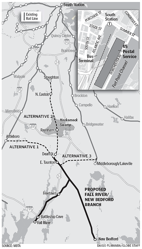
Image


Was this not posted?

  by mental757
 
it is now - thanks - looks good and clears up some of the proposed routing questions I had.

In my cross-eyed viewing of google maps, I also found an old ROW from Mansfield Station (at the roadway overpass) to the Taunton area - could that ever re-enter the equation??? (is that the old colony ROW someone mentioned above??)

Alternative 1 on the map, while out of the way somewhat to Boston might offer the people of FR/NB an option to Providence (which I'd like to see someday). While the Commonwealth is primarily concerned with in-State concerns first, the fact the FR in certain governement statistics tabulations, is part of the Providence metro area. Either way, there would surley be a large benefit in linking FR/NB with both PROV and BOS if there was a way. Attleboro would benefit as it would then serve as a transfer point between the PROV line and the new FR/NB service...

  by nev12
 
Wasn't there talk of an extention to the TF Green airport in Rhode Island.

  by MBTA F40PH-2C 1050
 
nev12 wrote:Wasn't there talk of an extention to the TF Green airport in Rhode Island.
the MBTA is currently expanding its service to TF green via the Northeast Corridor, the station is under construction


thanks GP40MC1118 and everyone for the answer :wink:

  by mental757
 
MBTA F40PH-2C 1050 wrote:
nev12 wrote:Wasn't there talk of an extention to the TF Green airport in Rhode Island.
the MBTA is currently expanding its service to TF green via the Northeast Corridor, the station is under construction


thanks GP40MC1118 and everyone for the answer :wink:
and to Wickford Junction in North Kingstown, RI. Both stations are funded and under the final stages of design with physical construction (the TF Green site has already been cleared and prepped) due to be complete in late 2009.
  • 1
  • 5
  • 6
  • 7
  • 8
  • 9
  • 88