NE2, I'm not certain I understand your answer. I realize that the row discussion is basically focused on the Cohocton from Batavia westbound to Buffalo. So let me ask this, where did the row go eastbound out of Batavia and what cities was it suppose to serve?
Railroad Forums
What was the "Old Conhocton Roadway" (Batavia-Buffalo)?
- Pertaining to all railroading subjects, past and present, in New York State.
Moderator: Otto Vondrak
East of Batavia, it was actually built and opened as part of the Erie.
The route east went from Batavia, through LeRoy and Caledonia to Avon and hence down the Corning branch to Corning. It was built in the opposite direction, i.e. started in Corning.
That's exactly right. The Cohocton r-o-w was constructed between Batavia and Corning but not between Batavia and Buffalo. It was built in the interests of the Erie to the then-standard 6' gauge of the Erie.
As a footnote to all of this it is worth noting that what later became the "Peanut Line" of the NYC was also built in the interests of the Erie and to 6' gauge. Its original name was the Canandaigua & Niagara Falls Railroad.
As a footnote to all of this it is worth noting that what later became the "Peanut Line" of the NYC was also built in the interests of the Erie and to 6' gauge. Its original name was the Canandaigua & Niagara Falls Railroad.
Today I went for a small drive and ended up finding out more about the Cohocton RR than I expected. After getting the car undercoated, I thought I would drive out to TIllman and check things out with the leaves down. But before I got to Tillman, I went down Barton [From Wehrle] to see what is around the WSRR crossing there. I've never been down there so I took a look. Well, there is nothing really to report. No left overs. Not even telegraph poles. Ballast, that's about it. I continued down Barton and came to the entrance to the quary. Nothing really to see from that point so I backed into an access road to a cell tower and turned around and headed to Tillman.
The end of Tillman is so heavily tree'd in that I couldn't see anything resembling a ROW. I drove down to Ransom and drove back but still couldn't see anything obvious. So, I came home.
While checking my mail it came upon me to check Erie.Gov aerail photo's from 1927. I started at Tillman and worked west. Then I opened up the 1951 aerial photo's in a seperate window and comparted them. The ROW in both years match. The ROW west of Tillman just barely touches Wehrle Dr as it slowy archs SW and then either parallels or joins the WSRR west of Harris Hill Rd. Buffalo Crushed stone isn't there yet but the ROW goes right down the middle if it. I then open up a third window and google map/sat the area. Sure enough, the ROW is still visible. Guess where it is.....it is the access road to the cell tower that I backed into. Couldn't believe it when I looked at it. The entrance to the access road is sitting on the ROW. The cell tower is about 100 feet south of it.
While "connecting the dots" I also noticed something else. At the intersection of Wehrle and Gunnville [opposite National Fuel] are stacked stone blocks. For years I always wondered about these and where they came from. I always assumed from quary operations or something. But, if you look at the google map/sat, you'll see that the row goes right over this area. Right in front of us the whole time.
http://www.erie.gov/aerials/1920s/atlas ... 7_l25.html
http://www.erie.gov/aerials/1951/photos/51_3H135.jpg
http://mapper.acme.com/?ll=42.95584,-78 ... 0Hill%20NY
Assuming I did this correctly, the "A" marker is the access road to the cell tower.
I re-read my Nov 9th post from last year. Well, I made some more headway on the ROW. After railfainning BNSF, I came back via Ransom Rd and down Tillman and then west down Wehrle. As I was driving along, I mentally placed the ROW where I thought it would be and were it would come out along Wehrle Dr. Just as I am coming around the curve about 1/4 mile before the intersection, I spotted what I think is a ROW buried in brush. If it wasn't for the light snow fall, I would have never spotted it even with the leaves off. While I can't conclude that this is in fact the row 100%, it sure looks like it.
At first I dismissed it as a berm for the quary. But then I realized there is no quary here. What I think is the ROW, is almost 1 foot above the rest of the land on either side of it. It continues in a straight line. It is heavily overgrown. The only way to confirm if this is the row, will be to walk on it, and dig it up and see if there is any ballast there. I will try and x-country ski into the area but it will be difficult. At least now, I now where it is.
The markes A and B are where it is viewable from the road.
http://mapper.acme.com/?ll=42.95912,-78 ... 0Hill%20NY
I love historical infrastructure!
According to Wm. Reed Gordon ("Erie RR, Rochester Div.") the Buffalo and Conhocton Valley was incorporated in 1850 to build from Corning to Buffalo. Operations began between Corning and Savonna in 1851 and the line reached Wayland in 1852 and Caledonia in 1853. Batavia was reached in 1854.
Grading was done 2 miles west of Batavia.
"On account of a high grade out of Attica, a financial deal and trade of rights-of-way were made. The Buffalo, NY and Erie stopped construction west of Batavia and the old road bed still can be seen."
That must have been between 1857-1863, the years that the Buffalo, NY and Erie existed. Sometimes Gordon's dates are not correct, but he wrote more about this than anyone else.
The Buffalo and Conhocton Valley became the Buffalo, Corning & New York in 1851 (or 1852). It seems that Gordon's text disagrees with his chart on page 4.
I have read this book and Pietrak's Shawmut book more than any others. Both are enlightening and chronologically confusing.
Several sources note the Erie leased the Buffalo, New York and Erie Railroad Company in 1863 for a period of 450 years:
1. http://www.octrr.org/caboosemotel/erierailroad1007.html
2. http://en.wikipedia.org/wiki/Erie_Railroad
3. http://wnyrails.org/railroads/erie/erie_home.htm
I even found a copy of a document from the NY State Assembly reporting the lease:
http://books.google.com/books?id=mHMbAQ ... 63&f=false
1. http://www.octrr.org/caboosemotel/erierailroad1007.html
2. http://en.wikipedia.org/wiki/Erie_Railroad
3. http://wnyrails.org/railroads/erie/erie_home.htm
I even found a copy of a document from the NY State Assembly reporting the lease:
http://books.google.com/books?id=mHMbAQ ... 63&f=false
Matt Langworthy
"It is highly likely that the 1990s were an overrated decade."
"It is highly likely that the 1990s were an overrated decade."
I read the posting above and it amazes me that something over 100 years ago still exists. But not for long. There is a for sale sign posted very near the row. If a contractor gets a hold of it, you can kiss it good bye.
You can see from aerial photos that there are practically miles and miles of BC&NY railbed that remain.
http://russnelson.com/unfinished-railro ... andNewYork
http://russnelson.com/unfinished-railro ... andNewYork

By the time the Buffalo, Corning and New York reached Batavia in 1854, the Buffalo and Rochester had already completed their line from Batavia to Buffalo.The Buffalo and Rochester then sold their Attica-Buffalo line to the Buffalo and New York City giving the latter a line from Hornellsville to Buffalo. Aaron D. Patchin was President of the B&NYC and Treasurer of the BC&NY. I think he was already planning the formation of the Buffalo, New York and Erie which was essentially a combination of both lines. Since he already had one route to Buffalo, he didn't need a second and that was then end of the Batavia-Buffalo project. Ted
Well, with the radical weather we've had this year I almost forgot to check out this ROW. It has snowed and melted and snowed again that I've lost count. But with the recent snow fall I headed out to the Tillman Nature Preserve. On my way home, I passed the ROW and it was highlighted with snow. So I turned around and parked the car and grabbed my camera and explored the line.....what remains anyways.
To me, it is clear that this is the ROW without question. With the snow on top, the embankment sticks out. There are many huge trees on this line. There are a couple of drainage ditches cut across the ROW. Between these two ditches the embankment almost disappears. I thought perhaps the work stopped at the first ditch because it is higher than the rest of it all the way to Wehrle Dr. But after crossing over the second ditch, the embankment makes a comeback before disappearing for good.
There is one patch that was clear of snow. I kicked around the dirt and only found two stones. With no one working on it since roughly 1853 or later, it's gotta be buried under a lot of leaves.
When I left, I took a video of this line and it is viewable from the street. Which is how I found it in the first place. But, Microsoft changed Windows Movie Maker to such an extend , that I no longer know how to use it. So it's going to take me some time to figure it out before posting it.
i took about 25 pictures but to cut down on the upload time, I posted only 15. Click here: http://www.railfan.net/railpix/submit/dansyrcher/
https://i.postimg.cc/TwqV1dZG/IMG-1152.jpg" onclick="window.open(this.href);return false;
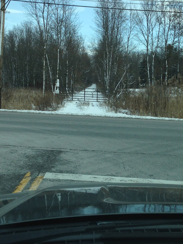
While taking my truck for a last run before taking it off the road, I drove out to Pembroke and stopped for gas. I took Rt5 east and turned south on Lovers Lane which takes me to Cohocton Rd. Which is in between Rt77 and the quarry. We had a little lite snowfall in the area and when I came to the end of Cohocton Rd, I see the very nicely highlighted Cohocton ROW at RT77 looking east. Private land posters are there for your reading pleasure but somebody has driven down it. I would love to x-country ski this line. Many many years ago, I flew over this row and somewhere it turns into a swamp.
While taking my truck for a last run before taking it off the road, I drove out to Pembroke and stopped for gas. I took Rt5 east and turned south on Lovers Lane which takes me to Cohocton Rd. Which is in between Rt77 and the quarry. We had a little lite snowfall in the area and when I came to the end of Cohocton Rd, I see the very nicely highlighted Cohocton ROW at RT77 looking east. Private land posters are there for your reading pleasure but somebody has driven down it. I would love to x-country ski this line. Many many years ago, I flew over this row and somewhere it turns into a swamp.
Interesting info thanks: one of those topics on ROW - "NOW" I know what that is..........
OK help me out - Going further south of Corfu on 77, the next abandoned ROW you can see across the pastureland - is that the LV? This is before Darien Lake Six Flags or what it is called now.
Mark
OK help me out - Going further south of Corfu on 77, the next abandoned ROW you can see across the pastureland - is that the LV? This is before Darien Lake Six Flags or what it is called now.
Mark