Railroad Forums 

  • Unfinished Railroads of New York State

  • Pertaining to all railroading subjects, past and present, in New York State.
Pertaining to all railroading subjects, past and present, in New York State.

Moderator: Otto Vondrak

 #800246  by alsorailfan
 
by dj_paige » Sun Apr 11, 2010 7:42 pm

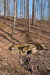
With the help of a local farmer, I was able to photograph an intact culvert under approx 30 ft of fill, created by the Rochester, Nunda and Pennsylvania RR, between Fowlerville and York. I also photographed another culvert, now collapsed, which is visible from Mt. Pleasant Road near York. All my photographs of culverts, fills, cuts and a few cows of the RN&P RR can be viewed at http://www.flickr.com/photos/15947776@N ... 482063104/ Also shown are four pages of property deeds relating to the RN&P RR.--
Paige
"It's nothing until I call it!" -- Bill Klem, NL Umpire, Baseball Hall of Fame, and native Rochesterian
My Flickr Photos
dj_paige
Wow, this now makes me think how many other possible both unfinished or finished but abandoned lines I might have passed by and not really noticed. Have a friend that lives a bit further east on Mt. Pleasant Rd. and while I have noticed a line, I dismissed it as just part of natural glaicer /farmers 'work'. Thanks for the great pictures and explaination to go with it! And how do you determine whether something is a flood cut and not a natural depression? And the Pennssylvania RR--isn't that the Greenway Trail and where does it merge or crosses the R Nand P RR ? Thanks in advance if you can answer these questions!!
Chris
 #800284  by dj_paige
 
this now makes me think how many other possible both unfinished or finished but abandoned lines I might have passed by and not really noticed
Russ Nelson has done the research on unfinished railroads, there aren't really that many in the Western NY/Rochester/Finger Lakes area. As far as completed but abandoned lines, there are numerous resources online, including Mr. Nelson's web site.
how do you determine whether something is a flood cut and not a natural depression
If there is a relatively smooth line of cuts and fills, that isn't a natural thing, its a railroad
And the Pennssylvania [sic] RR--isn't that the Greenway Trail and where does it merge or crosses the R Nand P RR
The former Pennsylvania RR is indeed the Greenway Trail; it doesn't cross the RN&P because the RN&P was only graded in a few locations.
 #800345  by alsorailfan
 
Thanks!

" 'how do you determine whether something is a flood cut and not a natural depression'

'If there is a relatively smooth line of cuts and fills, that isn't a natural thing, its a railroad' "

Had to smile at that as from the pictures it didn't look smooth, etc. (just probably me not noticing!) but then again it's better to see it in person for better perspective.
Thanks again!
Chris
 #800492  by RussNelson
 
dj_paige wrote:Russ Nelson has done the research on unfinished railroads, there aren't really that many in the Western NY/Rochester/Finger Lakes area.
Well, there's the Pennsylvania and Sodus Bay. That's not too far from y'all, and there are some excellent ruins to be seen, including a 30' high pair of abutments. I know it's route in Tompkins County courtesy of Hardy Campbell Lee and Wayne Rossiter, but I'm real iffy north of Ovid.

There's also the Sodus Bay, Corning, and New York, which like most railroads, was ambitiously named. I've seen a pier of the railroad, and a bit of its grading, but I am otherwise guessing about the rest.

You can use my locator map to find others. There are 31 in all:
Image
 #800694  by dj_paige
 
Russ

Have you made a similar NY State Google Maps overlaid with all rail lines (not the unfinished railroads, but the ones that actually had rail)?
 #1006448  by keng
 
Russ has done a nice job on the unfinished railroad site!

Re: Rochester, Nunda, and Pennsylvania

Confirmed the grading at Bowen Rd. Couldn't see where it crossed Stottle, but using birds-eye view on Bing Maps it jumps right out.

I happened to meet a guy who owns land on Stottle. He was not aware of this unfinished railroad, though he grew up in the area in the 50's and pretty much lived in the woods and playing around Black and Mill Creek. We found a small portion of the right of way on his land, where the line on Russ's map ends.

Traces of the grading end where the line ends- there is a large artificial pond and field there now. Anyone know if anymore grading was done to the Northeast? The owner is interested and wants to check it out when the weather is favorable.

Ken
 #1006941  by FarmallBob
 
keng wrote: Re: Rochester, Nunda, and Pennsylvania...

Confirmed the grading at Bowen Rd. Couldn't see where it crossed Stottle, but using birds-eye view on Bing Maps it jumps right out...

...Traces of the grading end where the line ends- there is a large artificial pond and field there now. Anyone know if anymore grading was done to the Northeast?
Ken -

When I last walked the area - probably 35 years ago - traces of grading were evident in the small fields northeast of where the artificial pond now sits. The grading petered out just shy of the woods that border Black Creek.

The grading was only a few inches higher than native grade, significantly eroded and was entirely missing in spots. It was difficult to discern even when standing atop the grading - it looked more like a backfurrow from farm plowing than a RR grade. But it DID run in a straight line northeast across the fields.

AFIK there was no grading north of Black Creek. Nor is there any evidence of a foundation for a bridge that was to have carried a railroad over the creek.

Incidentally current aerial photos reveal no traces of this grading. I suspect subsequent farming activities (including burying a couple fence rows to create a single large field) obliterated whatever traces of grading that once existed here.

...FB
 #1007041  by dj_paige
 
FarmallBob wrote: Ken -

When I last walked the area - probably 35 years ago - traces of grading were evident in the small fields northeast of where the artificial pond now sits. The grading petered out just shy of the woods that border Black Creek.

The grading was only a few inches higher than native grade, significantly eroded and was entirely missing in spots. It was difficult to discern even when standing atop the grading - it looked more like a backfurrow from farm plowing than a RR grade. But it DID run in a straight line northeast across the fields.

AFIK there was no grading north of Black Creek. Nor is there any evidence of a foundation for a bridge that was to have carried a railroad over the creek.

Incidentally current aerial photos reveal no traces of this grading. I suspect subsequent farming activities (including burying a couple fence rows to create a single large field) obliterated whatever traces of grading that once existed here.

...FB
Fascinating stuff ... thanks for sharing.
 #1007200  by RussNelson
 
I think I found a little bit more grading on the aerial photos on the north end of the south part of the unfinished grading (http://www.openstreetmap.org/browse/way/48842725):
http://mapper.acme.com/?ll=42.90844,-77 ... donia%20NY

And maybe on the south end of the north part of the unfinished grading (http://www.openstreetmap.org/browse/way/75607838)::
http://mapper.acme.com/?ll=43.04011,-77.81851&z=17&t=H -- see the line sloping to the northeast in the trees? Also, it looks to have gone as far south as Morgan Road -- which is why I have it drawn that far -- but it might go further south.

It would be superkeen to join these two bits together. Anybody want to take a visit to the Monroe County offices to see if there's a map registered for the RN&P? If they had started building, they surely had a franchise with NYS, which required maps to be registered with the affected counties.
 #1007225  by dj_paige
 
RussNelson wrote:I think I found a little bit more grading on the aerial photos on the north end of the south part of the unfinished grading (http://www.openstreetmap.org/browse/way/48842725):
http://mapper.acme.com/?ll=42.90844,-77 ... donia%20NY
I agree with you on this one, Russ. This new segment seems to "align" well with the known grading in the Fowlerville area. I have added some pins to the map to show what I mean. Location "H" is the approx 30 foot high fill with a culvert that I visited and photographed.
Image
Rochester, Nunda and Pennsylvania RR by statPaige, on Flickr
RussNelson wrote: And maybe on the south end of the north part of the unfinished grading (http://www.openstreetmap.org/browse/way/75607838)::
http://mapper.acme.com/?ll=43.04011,-77.81851&z=17&t=H -- see the line sloping to the northeast in the trees? Also, it looks to have gone as far south as Morgan Road -- which is why I have it drawn that far -- but it might go further south.
I'm a little more skeptical about this one. Although it "aligns" with the RN&P grading at Morgan Road, when I look at the same area on Bing Maps, I see a stream that goes under the Thruway and continues north, and to the east of the golf course. The stream is unusually straight, but perhaps it was straightened and moved to this location when the golf course was built.
 #1007261  by FarmallBob
 
RussNelson wrote:And maybe on the south end of the north part of the unfinished grading (http://www.openstreetmap.org/browse/way/75607838)::
http://mapper.acme.com/?ll=43.04011,-77.81851&z=17&t=H -- see the line sloping to the northeast in the trees? Also, it looks to have gone as far south as Morgan Road -- which is why I have it drawn that far -- but it might go further south.
Interesting Russ...

As time/weather permit I'll try to visit this spot to see what it looks like from the ground.
RussNelson wrote:Also, it looks to have gone as far south as Morgan Road -- which is why I have it drawn that far -- but it might go further south.
The south end of that grading ends very abruptly at the edge of the woods on the north side of the power line ROW. I've been unable to spot any trace of grading south of that spot - ie in the cleared area beneath the power lines, nor in the thick brush/woods lying between the power lines and Morgan Rd.

That's not to say there wasn't grading performed. Could be subsequent agricultural activity and construction of the power line simply obliterated traces of grading here.

...FB
 #1015994  by RussNelson
 
FarmallBob wrote:
RussNelson wrote:Also, it looks to have gone as far south as Morgan Road -- which is why I have it drawn that far -- but it might go further south.
The south end of that grading ends very abruptly at the edge of the woods on the north side of the power line ROW. I've been unable to spot any trace of grading south of that spot - ie in the cleared area beneath the power lines, nor in the thick brush/woods lying between the power lines and Morgan Rd.

That's not to say there wasn't grading performed. Could be subsequent agricultural activity and construction of the power line simply obliterated traces of grading here.

...FB
Another possibility is that it only shows up in aerial photos. I've seen that before, in the Sackets Harbor & Ellisburgh. I could see the route through a field very clearly on the aerial photo, but standing there I would *never* have said a railroad went through there for ten years, much less an unfinished one. At another location on the same railroad, the only thing I could see was a little bit of taller trees on the fenceline. I know I wasn't wrong, because I found the railbed marked on an earlier set of topographic maps. On the ground? Absolutely nothing visible in the fenceline. I couldn't even identify the taller trees. And I was looking at the location on a GPS receiver, so I was where I had seen it in the aerial photo.

http://russnelson.com/SHnE/
 #1117023  by RussNelson
 
Found another unfinished railroad. This one is at the Hasenclever Mine, in Harriman State Park. They were going to build a narrow gauge railroad down to "the river", which I expect was the Hudson River. Constructed a few hundred feet of grade starting at the mine.

I speculate that they did so in order to convince investors that it was possible to build a railroad, and that they were serious about doing so. If they were *really* serious about building a railroad, they would have started at multiple points, like so many other unfinished railroads did.
 #1117109  by map193
 
Hi Russ,
You have done a great job on everything and you have brought to light a lot of fascinating railroad history that has been covered up for way too many years.
Have you found any information on the Atlantic and Great Western expansion in recent years? I live in the area where this line was supposed to be built and I know of a couple sections where there are abandoned R.O.W.s. I have been interested by this line for a while and there isn't much information online or in books about it. I know that wnyrails had some great information but it seems that they have gone the way of this line. From looking at acme mapper I might have determined where this line would have "met" the Erie (about 2 miles southwast of Cattaraugus). I would assume that the line would have headed northwest out of the town of New Albion, and passed through a valley about 1 or 1.5 miles away. At this point they would have had to tunnel under the Erie R.O.W. which is at least 50 feet directly above. Once it passed through that valley it would have entered another valley and would have made a turn in one of two directions. It could have gone turned south southeast out of this valley and then hooked around to the north in order to maintain an elevation of about 1400 ft which is what i am assuming the line would have been at. Or it could have ran towards the north and crossed ST RT. 353 and ran parallel to Lovers Lane Rd and would have crossed Pepperdine Hill and Potter Hill and ran towards Otto. There are remnants of the grade on Pepperdine Hill in New Albion. Allegedly there are remants of the grade in North Otto Right by the Zoar Valley Gorge and in a spot to the west of Otto. The plans were to build a trestle across the Zoar gorge but the core samples showed that the shale was not stable enough to hold a trestle. They knew that the ground was unstable in the Cattaraugus Creek area in the early 1870's, I'm not sure why they couldn't have figured this out in 2006 when they were trying to build the 219 extension right outside of Springville! The unstable core samples, lack of funds,the panic of 1873, and an aggressive campaign by the Erie Railroad all put a nail in the coffin for this expansion. There are some local historical sources that mention this line, but that's about it. I can't quite recall the names of the books. I think one was called the "History of Cattaraugus County." This mentions the grading in North Otto and hints at the fact that there might have been some corruption or a lack of funds. I don't exactly remember. The author writes about how the Irish Immigrants were waiting for their paychecks at the end of the week but the boss refused to pay them, so at night they went down to the office and broke into the safe and found that it was empty! The Gowanda Pennysaver had a feature on this line about 8 or 10 years ago and attributes the panic of 1873 to the lines demise. I have yet to find that article in years since. When I have more time I'll post a little bit more of what I have and Ill try to make a map on acme mapper and I'll post it. I also know a couple old timers who might know some more. I hope this helps you out a bit. Good Luck!
-Marcus Pisa
  • 1
  • 9
  • 10
  • 11
  • 12
  • 13
  • 14