Railroad Forums 

  • N.Y. & N.E. RR. - Beecher at Highland Lake , 1879

  • Pertaining to all railroading subjects, past and present, in New England
Pertaining to all railroading subjects, past and present, in New England

Moderators: MEC407, NHN503

 #1228040  by MaineCoonCat
 
Beecher1light rrnet.jpg
Courtesy of Barbara Bartholomew, Norfolk Historical Society (and my late Love of My Life's aunt). Note that it is believed that this is an image of a reproduction. Image posted has been reduced due to phpBB's size restrictions. If you wish a full size copy, please PM me.

Moderators, please relocate this if I posted it in the wrong spot.. Thanks!
 #1228050  by Cosmo
 
Amazing find!
Highland lake, just North of Norfolk, on the long tangent after clearing the curves South of Walpole Jct.
I know the spot well.
When I was young(er) and (more) freakish, I would often bike out from Westwood (did I mention I was an insomniac bicyclist?) on summer nights and get there in time to watch the last train of the night as it whizzed through the crossing.
The site at that point had not changed much in the 20 yrs hence, so one could imagine that it was still a New Haven train coming down from Boston, and with an active enough imagination, picture what it was like when the White Train made the same run 100 years before.
It was also nice in the daytime. :wink:
 #1228056  by elecuyer
 
Looks like there was a combination of two sections from south/west for this event. One east up from Putnam Ct, the other north from Valley Falls RI. Given the schedule (and the lines in 1879) they must have combined at Franklin.

Interesting that the NY&NE didn't start the RI section from Providence. Did they not have trackage rights on the P&W?

Imagine, 2 trains from Boston, one from CT, and one from RI - all to see a preacher and concert of sacred music. My, how times have changed.
 #1228058  by MaineCoonCat
 
My understanding is that there is ongoing research into the history of Highland Lake Park. I'll keep sniffing for railroad related aspects and share them as is appropriate and in a timely fashion (as best as I can).. Guess it was quite the place "back in the day".
 #1228470  by MaineCoonCat
 
I was talking further to Barbara B.. The N.Y & N.E. actually owned the park beginning ~ 1875. (Wow, and I thought "trolley" lines had come up with the idea of amusement parks for destinations!). Supposedly there was a spur somewhat paralleling Seekonk Street. The ownership of the park was transferred with the ownership of the railroad to the N.Y.N.H.&H. around the beginning of the 20th century. The N.Y.N.H.&H had little interest in running an amusement park so in 1910 it was sold to the Quincy City Ice Co. (which also made use of the spur)and sometime in the 1930's was taken for unpaid taxes and sold.
 #1301754  by MaineCoonCat
 
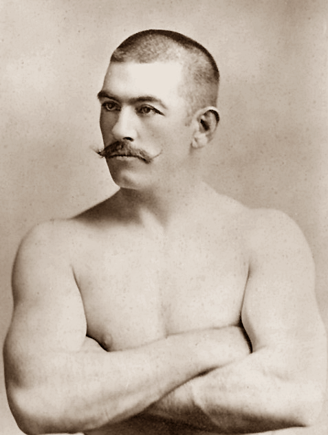
j l sullivan s221111.jpg
 #1302989  by MaineCoonCat
 
shepaug wrote:Elaboration ???" "


Highland Lake ? There was Electric Park that some fragments lasted into maybe 195o's (???) A Trolley Park. http://www.schaghticoke.net/coltsfoot/d ... nsted2.jpg
This was located in Norfolk, Massachusetts. not to be confused with Winstead, Connecticut. The park was owned by the N.Y. & N.E... In these games, John L. Sullivan, (the heavyweight boxer) appeared.

From Wikipedia:
John Lawrence Sullivan (October 12, 1858 – February 2, 1918), also known as the Boston Strong Boy, was recognized as the first Heavyweight Champion of gloved boxing from February 7, 1882, to 1892, and is generally recognized as the last heavyweight champion of bare-knuckle boxing under the London Prize Ring Rules. He was the first American athlete to earn over one million dollars.

Image
http://en.wikipedia.org/wiki/John_L._Sullivan
 #1309175  by MaineCoonCat
 
Cosmo wrote:Can anyone find, or does anyone have any pics of the Highland Lake station they can post here?
Your wish is my I'll do my best..

From Barbara Bartholomew of the Norfolk Historical Society. Only one she's found so far.. Click the image to enlarge.
hiland station history003.jpg
For a "plan" of the Norfolk County Railroad, see: http://archives.lib.state.ma.us/bitstre ... sAllowed=y Click on the map to enlarge it.
 #1309180  by Cosmo
 
Wow! There's way more than I hoped there!
That map is amazing! If you scroll right past "South Dedham," (now "Norwood,") and look just a tad North at "West Dedham, (now "Westwood,") you see "Buckminster Pond," (now "Buckmaster Pond"). I grew up, and my parents still reside, on "Buckmaster Road" on the shore of that pond.
Amazing how things changed over the years!
 #1326678  by MaineCoonCat
 
Received this from Barbara Bartholomew;

Barbara Bartholomew of the Norfolk Historical Commission wrote: PRESS RELEASE FOR OPENING OF FALES MEMORIAL PARK


On Sunday, April 26, 2015, the Ceremony for Opening the Fales Memorial Park

Preserve will be conducted at 2:00 P.M. at 24 Campbell Street, Norfolk, by the Arch Bridge.

This location will serve as the main entrance to the Park. The land that has been designated

as Fales Park at Highland Lake in 2008 was purchased with Community Preservation funds. This tract

on the east side of Highland Lake replaces the original 13 ½ Acres of Fales land that Bertha

Fales donated to the Town of Norfolk in 1943. The original parcel was located north of Campbell

Street on the west side of the Stop River. This land was taken by eminet domain in 1980 and

became part of the Chales River Vallley Natural Storage Area under the jurisdiction of the

U.S. Army Corps of Engineers.

The Norfolk Historical Commission has spearheaded the effort to establish this park

commerorating the contributions of the Fales Family to the Town of Norfolk . Finally 72 years

after Bertha donated land for a Memorial Park it will become a reality on April 26, 2015.

The Norfolk Historical Commission and the Walpole Historical Society invite you all to

join us to mark this occasion. "
press release park1.jpg