Railroad Forums 

  • Mystery Photos New England?

  • Pertaining to all railroading subjects, past and present, in New England
Pertaining to all railroading subjects, past and present, in New England

Moderators: MEC407, NHN503

 #1201689  by ferroequinarchaeologist
 
Cowford,

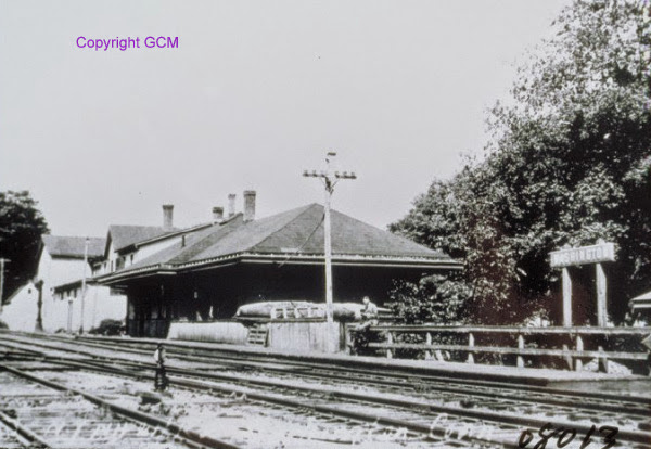
>> The 3-4' "fence" comes out flush with the operator's bay.

I think that the "fence" is actually a loading platform. This would also explain the "boardwalk" of the same length between the tracks and the platform, and the unusually tall doorway between the bay and the near end of the building. I'm also intrigued as to why a railroad station has no obvious access from the building to the tracks for either passengers or freight, unless it was no longer in use as a railroad facility at the time that the pix was taken. This would also explain the absence of an order board.

PBM
 #1267174  by trainsinmaine
 
I got to thinking about this first picture this morning, posted last July, and the accompanying thread that proceeded it; now that the dust has long settled, after all the give-and-take, has anyone yet figured out where this is located?
 #1269295  by wally
 
the building in the center appears to be some sort of store (perhaps abandoned even when the picture was taken). there is a signpost along the right front edge of that building, and it is a mobilgas sign (pegasus is visible). below the sign, to the right, there is a gas pump (white object).

the long, low building to the left (not the one with the tall windows) appears to be a lumber storage style building (lots of sliding doors on the second floor and perhaps roll-up doors on the ground floor (could also be swing-open doors).

no idea where, though.

wally
 #1270275  by Ridgefielder
 
trainsinmaine wrote:Boy, do you have a keen eye! I never noticed that Mobilgas sign --- which may place this a bit later in time than I had originally thought.
Mobilgas was the trademark of Socony, f/k/a Standard Oil of New York. Most Socony stations were in NY and New England, so that at least makes it likely the location is somewhere in the Northeast.
 #1270765  by wally
 
ferroequinarchaeologist wrote:The change from Mobilgas to Mobil happened in 1963, so the pix must date from around the middle 'sixties or earlier.
not necessarily. if the gas station/store was abandoned, the sign could have stayed up for years, which could make the photo into the late 60s or early 70s. not saying it is, just that it's possible.

to me, it does look as though many of the buildings are abandoned. also, is that "chalkboard" chalk, like from an eraser, on the loading/platform in the lower right of the photo? that might indicate a school very nearby.
 #1270796  by trainsinmaine
 
Consensus seems to be that this village looks like it had had better days, and that it might have been abandoned at the time this photo was taken. I know this is a long shot, but having exhausted other possibilities, I'm wondering if this might be the original Hill, New Hampshire, near Franklin, around the time that the village was relocated in 1940 to make way for a flood control project. A branch of the B&M used to run through it, and the picture looks like it could have been taken at around that time. I've never visited the place, however, and haven't yet found any online photos that depict the village with the rail line.

Would some more knowledgeable soul like to chime in on this?
 #1361917  by Ridgefielder
 
Excuse the bump of this long-dormant thread, but- I think the station is Allerton Farms, on the old NY&NE line over Towantic Summit.
 #1362046  by trainsinmaine
 
Hmmmm . . . Don't know. I checked out the website TylerCityStation.info, which contains photos of many old depots in Connecticut, and it does have a couple of pictures of the Allerton Farms station. There are similarities, but I wonder. The Allerton Farms building had a loading platform, which this doesn't (unless it had been taken down before the photo was made), and the telegraph poles are on the wrong side.

You know more about this place than I do; why does it look so forlorn? What is there now?
 #1362465  by B&M 1227
 
I don't think it's allerton farms because this depot has a hipped roof. I'm still over a year later puzzled by this picture... I'm tempted to agree with folks that its a terminus given the cinders, and what could be a watering standpipe on the depot side of the tracks. The hopper car, which to me looks to be of the USRA 55ton design, potentially narrows the era down to about 1920-1960s. I can say with 95% certainty that its not a Rutland branch. I'm fairly certain that is not B&M either. I suppose it could be NH or MEC. Other than the standpipe which is a little more "big-railroad-ish," the picture has a lot of characteristics of an upstate NY branch or shortline. From where we go with that I don't know...
 #1362675  by Ridgefielder
 
Thing is, though, that I can't find a branch-line terminal station in New England that fits. I looked at every one that I could find online, and all the old topo maps, and either the station building looked wrong, or the layout of the surrounding village- road up a hill to the left of the tracks, another road crossing the tracks in the distance, a store/gas station by the level crossing, a church or grange hall up on the hill- was wrong. That's what lead me to think that maybe we're looking at a through route that's being downgraded-- which is why I got excited about Allerton Farms, on the old NY&NE over Towantic summit, since it had a loading platform that matched... but, as you say, that station didn't have a hipped roof.

Several things about the picture make me think we're looking at the 1920's or '30's, 40's at the latest. One, the sepia tone itself-- I can't say for sure, but I think that was long out of fashion by the time of the Second World War: we have plenty of old family snapshots from the '30's and they're all normal black & white. Second, the wood plank platform: post-WW2, it seems to me most ground-level platforms would have been asphalt, not wood. And third, the rail: hard to tell exactly, but that stuff sure looks light- maybe 75lbs?

So, if not the line over Towantic Summit, could we be looking at someplace on one of the Central New England lines west of Canaan? Maybe a couple years before the New Haven pulled the rails in the late 1930's?
 #1362731  by B&M 1227
 
Gentleman we have an answer!

Thanks to George Ford Jr from the B&M depots/structures group, we now can rest easy knowing its Washington CT on the New Haven's Litchfield Division, abandoned 1948.
12375198_1048653228489364_6010887701761137595_o.jpg
12375198_1048653228489364_6010887701761137595_o.jpg (135.7 KiB) Viewed 1510 times
1625787_1048754125145941_5134403799667384345_n.jpg
1625787_1048754125145941_5134403799667384345_n.jpg (79.22 KiB) Viewed 1510 times
http://www.schaghticoke.net/coltsfoot/d ... tonct2.jpg" onclick="window.open(this.href);return false;

Ooof, that took a long long while.
 #1362736  by trainsinmaine
 
Wow! I guess it did. Many thanks! I was just about to post a response that I was stymied when your post appeared. This has taken almost two and a half years!

I looked up Washington Depot. It is most definitely not the sleepy place that it was when this photo was taken. It seems to be a lively little fringe suburb.