Railroad Forums 

  • PRT map of Willow Grove Park

  • This forum is for discussion of "Fallen Flag" roads not otherwise provided with a specific forum. Fallen Flags are roads that no longer operate, went bankrupt, or were acquired or merged out of existence.
This forum is for discussion of "Fallen Flag" roads not otherwise provided with a specific forum. Fallen Flags are roads that no longer operate, went bankrupt, or were acquired or merged out of existence.

Moderator: Nicolai3985

 #655727  by Otto Vondrak
 
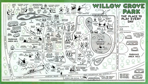
Going through the collection, discovered this great old map of WIllow Grove Park. I'm sure there are folks out there who can help me date this. From a brochure produced by the PRT advertising the best way to get to the park. Willow Grove Park was open from 1896 through 1975, and was conceived and built by Philadelphia Rapid Transit, an example of a "trolley park."

Image

Enjoy!
 #655739  by rdgrailfan
 
Interesting Map...forgot about how big the park originally was, i live within 5 blocks of the old park site. Based on some quick research the map is before 1945, Key to that date is shown below. The parking lot show on the right in in Upper Moreland township, the park was Abington " across the new Moreland road" is where the shopping center is today. The trolley barn was torn down about 6 years ago, the tunnel under Easton road still exists but is blocked over

The thirteen and a half acres of the Park lying in Willow Grove was purchased
in 1945 by the Hankin Brothers and developed into a shopping center with the
Penn Fruit Supermarket opening in 1947, followed by Snellenberg’s Department
Store and G. C. Murphy’s Store in 1953. The amusement portion of the Park was
then purchased by the Hankins in 1958 and a 116 lane bowling alley, the largest
in the world, built on the Moreland Road side. About 1970, a syndicate leased
the amusement section of the Park and converted it into a theme park called
"Six-Gun Territory" which gave it a western flavor.
The days of the once glamorous Willow Grove Park, famous the world over, came
to an end on April 14, 1976, and it was demolished to make way for a giant
shopping mall.
 #655883  by polybalt
 
I would think the map dates from the 1930's. The streetcar looks like a PCC, so the map was produced after PRT got PCC cars. But the various busses look pretty old to me. I doubt PRT would depict obsolete busses. I am no bus expert, but I suspect the engine forward busses and the double decker were gone by WWII???
 #655923  by JimBoylan
 
The 1st PCCs were made in 1936, PRT got their 1st in 1938.
PRT became PTC by 1940 and the initials on the equipment
were changed, so the map is most likely from 1938 or 1939.

Trolley Rte. 55 became bus to Wilow Grove in 1940, World
War II caused double deck and other old buses to last longer than
you would expect, to about 1945 or 1947, Rte. 6 got PCCs in 1947.

Thanks for sharing.
 #656032  by walt
 
Mid to late 1938 or 1939 sounds about right. The first PCC cars were delivered to the PRT in July 1938, and it had become the PTC by January 1, 1940.
 #656064  by CarterB
 
Good history website about the park:

http://www.wgpark.com/page.asp?page=5

Post card showing the trolley tunnel:

http://www.countryjoescollectiblestuff. ... rance.html

Last trolley car to the park:

http://www.phillytrolley.org/6lastcar.html

Trolley and Reading Station photos (page 33)

http://books.google.com/books?id=13jppp ... t#PPA33,M1
 #657562  by delvyrails
 
Thanks, Otto. The map is among the Park memorabilia on display in the lobby of the Upper Moreland Free Public Library, now located just off the upper right corner of the map itself.

On the park's site today, Willow Grove Park shopping mall has a park theme; and it displays several pictures of the park. Also, you can see a large mural of an open trolley at layover in a bank building a half mile west of the mall at the south corner of Moreland and Fitzwatertown Roads.

Arcadia's "Images of America" book series includes "Willow Grove Park", which includes over 30 pictures of trains, trolleys, or just tracks in the area.

Over long stretches, the route 6 right of way (center strip, private ROW, road-side, and in-street) between the Philadelphia city line and Willow Grove is quite evident even today.
 #674155  by Otto Vondrak
 
delvyrails wrote:Thanks, Otto. The map is among the Park memorabilia on display in the lobby of the Upper Moreland Free Public Library, now located just off the upper right corner of the map itself.
Good to know the map is not "lost forever." Thanks for letting me know about the display copy!
 #696445  by JimBoylan
 
In 1958, center of Ogontz Ave., Center of Limekiln Pk., private right of way from opposite Cedar Hill Apartments Number 1 through Cheltenham High School grounds, Keswick Ave., North side of Jenkintown Rd., East side of Tyson Ave., center of Tyson Ave., West side of Tyson Ave., West side of Edgehill Rd., Rockwell Ave., South side of Old Welsh Rd., West side of Reading RR, Berrell Ave. (not paved back then), loop between Davisville, Mooreland, and Easton Rds.
 #834552  by bubbalufagus
 
Jim,

I always wanted to know exactly how the route 6 trolley would make its way to Willow Grove Park. Thanks for your post. Do you have a map or anything of the actual route? Also, why did the trolley stop going to Willow Grove Park? Do you know if you can still see any of the old right of ways or tracks along that route?
 #834934  by JimBoylan
 
North of Keswick Ave. and Jenkintown Rd., there are plenty of traces, but all rail is gone. I think that the rail in Keswick Ave. was also pulled, South of there, rail is also gone. Some of the brick paving along Edgehill Rd. and Tyson Ave. survives, and the substation at the Church Rd. grade crossing is now a private residence. Traces of the bridge over the Reading company beside Welsh Rd. survive.
For some time before 1941, outbound cars made a big loop via Welsh, Old York, and Easton Rds., returning via the 1958 route mentioned earlier.
 #834983  by CarterB
 
I found the quite evident ROW in the brick pavers along Edge Hill Rd by Ridgeview Ave to Keith Rd., where along Keswick Ave and Jenkintown Ave are the traces? Which corner of Church Rd. was/is the substation?
 #834995  by JimBoylan
 
CarterB wrote:where along Keswick Ave and Jenkintown Ave are the traces? Which corner of Church Rd. was/is the substation?
North side of Jenkintown Rd., where tracks were at the side of the road, grading is evident. Keswick Ave. is well paved over, unless cracks or potholes open, no traces will be seen. New St. off Keswick Ave. is also a trace of the trolley, it was the access to the Glenside Trolley Freight Station.
NorthWest corner for the stone substation, now a house..
 #836271  by walt
 
bubbalufagus wrote:Jim,

Also, why did the trolley stop going to Willow Grove Park?
This was the result of the "great NCL bustitution" of the late 1950's in which 2/3 of Philadelphia's streetcar lines were bustituted. Originally, the NCL controlled PTC proposed to bustitute the entire route from Broad & Olney to Willow Grove, but the city objected, citing, in part, the inability of the highways outside the city upon which the buses would travel to handle the new GM equipment. Once those highways were widened, bustitution of the portion outside the city limits was approved, but the city's opposition resulted in the city portion ( Broad & Olney to Cheltenham & Ogontz) remaining a streetcar line. Thus, for a time, you had both a No. 6 bus and a No. 6 streetcar route with the bus operating all the way to Willow Grove and the Streetcar terminating at Cheltenham & Ogontz. The streetcar line lasted well beyond the takeover of the PTC by SEPTA. It appears that the current Route 6 bus route is actually the post NCL streetcar route, and that SEPTA's Route 22 most closely ( but not exactly) resembles the No 6 bus route outside of the city to Willow Grove.