Railroad Forums
Ghost Interurbans and Trolley lines.
- This forum is for discussion of "Fallen Flag" roads not otherwise provided with a specific forum. Fallen Flags are roads that no longer operate, went bankrupt, or were acquired or merged out of existence.
Moderator: Nicolai3985
The tracks south of Heath St. on the old Arborway Line are pretty much still there - they have been paved over. Also, the "trolley station" that now exists at Forest Hills Station was never used as a trolley station. Trolleys terminated at the Arborway when the line was running. The Arborway currently is just used for storage for CNG buses. The Rozzie Square power sub-station is not tied up due to "contamination", but by problems regarding usage of the old structure. Inside, it is still a pigeon condo with a lot of original equipment intact (at leat the last time I was inside). The reason that outer Washington Street past the Parkway is so wide is that their used to be trolley right of way in the middle - track south of Forest Hills was owned by the Eastern Massachusetts Street Railway Company and used by BERy, MTA.
Remnants of the old Pennsylvania and New Jersey Traction Co.
are visible north of Yardley Pa. along Taylorsville Rd.
At various points the ROW is visible along the west side of the
road. Power poles use the ROW in many locations making
identifying easy.
The old Brownsburg substaion in Upper Makefield is still
extant and is used a personal residence just off of Pa. 32.
Little of any ROW exsists south of Yardley to Morrisville.
crij wrote:In Connecticut, from what I have been told, there has always been a rule that no interurban/trolley could cross a railroad at grade.But Connecticut trolleys did switch onto railroad tracks and later switch off to the other side! Tomlinson Bridge on Forbes Ave. in New Haven, East Hartford, and North of New London, for instance.
Was this rule the same for most states, or was Ct a rairity??N.Y., N.J., Pa., Md., Fla., O., Ind., Ill., Col., Mo., and maybe other states all had grade crossings between railroads and trolleys or interurbans. Fla. and Pa. still do!
Did anybody ever figure out the route of Trolley branch to Highland Lake?
I can't figure anything going up that grade to get there.
I can't figure anything going up that grade to get there.
Regarding zz4's comment from under the ground:
If you mean Highland Lake, Town of Winchester, Connecticut, the trolley did climb the hill from Burrville, as I understand. Because the Connecticut Company trolley route from Winsted to Torrington ran east of (and parallel to) the Naugatuck Railroad, the branch going west to Highland Lake had to cross the steam railroad somehow (at grade? by bridge?). I suspect that the answer can be found somewhere in the publications of the Warehouse Point museum.
Joe McMahon, whose Dad lived in Winsted, had no automobile, and rode that system.
If something goes over large grades most likely evidence remains? vs. a line on flat ground....
Maybe it is the road that climbs up there now?
Also at very south end of Highland Lake there appears to have been 'something' there at one time. (now State Property?) Was this the location of 'Electric Park' ?? An old Trolley Park. As small as they might have been seems about every Trolley needed the 'park'.(or wanted one?)
I could not find one map in Winsted Library. In Torrington if you ask for something pre-2000 they treat you like a crook. Nothing exists. (it used to)
I asked a few I met at the lake last summer about Trolley line and was passed off as totally nuts.
ok---Joe McMahon...he still alive?
In response to zz4:
Dad, born in Winsted 1897, passed away in 1973. I share his name, Joe McMahon, and his hobby, railroads. However, when I could have learned a lot of Connecticut railway history from him, I was busy with studies and employment, so I learned less. His grandfather, Thomas McMahon, moved from Chatham, New York, to Winsted about 1870 and got a job with what became the Central New England Railway. That is why I attend the CNE historical bus explorations each spring, as posted elsewhere on railroad.net forum by Bernie Rudberg. Because we did not own a car, he and I never traced the Torrington Division trolley routes, even though he rode it often. Our views between Torrington and Winsted were out the windows of trains or buses.
-------
Speaking of public libraries, I am sometimes frustrated by the appointment of professional librarians to historical collections when some of those librarians really don't have enthusiasm for the treasures they guard. It varies from library to library.
ok...thank you...
I know little of the subject but some town/city libraries seem to treasure what history they have and some claim to have nothing.
Torrington. There was..I was told...a historical/reference section on 2nd floor but the lady that managed it was only there certain days.
2006 I am told there is NOTHING. (odd)
Maybe they transfer 'old stuff' to make money off it?
Bridgeport is frustrating. I'd swear the lady that oversee's the section is drooling to go commercial.
Ya know....tax dollars..library...serve community.... If I donated something to a library for the purpose of 'being public' I don't want to see somebody selling it.
Yet many libraries are under-funded and can't keep up to what they have.
The State Library in Hartford, Ct. one gets a sense most everything is falling apart.--except the building..beautiful building....
Maybe Torrington has ghosts?
I don't know whether they exist or not but made some visits to Ansonia library and the historical/reference section was always closed/locked up and the lady that over-saw it vanished somewhere.
Maybe my imagination but I'd get the key and spend little time in there. Something felt VERY UNCOMFORTABLE. NOT ALONE. I never felt such elsewhere.
I never said anything but made a mention 2006. Is something wrong up there? (still locked up,etc.)
One librarian blurted there are 'GHOSTS UP THERE'. Books move by themselves. Things get tossed around. The Librarian (#1 one I think)(another one) said they even have had those psysic (sp?) ghost hunters in there.
Soooo last trip it was late evening and I decided NOT to spend time in that section. I had to drive home alone late at night,etc. I have enough troubles without ghosts taking 'a liking' to me.(or dis-like)
Newtown supposedly has ghosts.
I don't know fact/fiction.
I did not start the rumor.
3rdrail wrote:The tracks south of Heath St. on the old Arborway Line are pretty much still there - they have been paved over. Also, the "trolley station" that now exists at Forest Hills Station was never used as a trolley station. Trolleys terminated at the Arborway when the line was running. The Arborway currently is just used for storage for CNG buses. The Rozzie Square power sub-station is not tied up due to "contamination", but by problems regarding usage of the old structure. Inside, it is still a pigeon condo with a lot of original equipment intact (at leat the last time I was inside). The reason that outer Washington Street past the Parkway is so wide is that their used to be trolley right of way in the middle - track south of Forest Hills was owned by the Eastern Massachusetts Street Railway Company and used by BERy, MTA.BERY owned all tracks within the city limits.... including tracks to charles river loop, down hyde park ave and down washington street to the Dedham line.
The Eastern Mass came into play in 1918 and only ran the norwood line, this was the only route disconected from the rest of their system.
Replace the 57 with the Green Line!!! The people demand more transit, more new routes
$75 K raised for Middlesex & Boston trolley #41 :: Seashore Trolley Museum
$75 K raised for Middlesex & Boston trolley #41 :: Seashore Trolley Museum
Third Rail is generally right about the ownership south of Forest Hills Sq. it was built and originally operated, by an Eastern Mass. predecessor. However, it was leased to the BERY around the turn of the century, as far as the Boston line. At that time, Hyde park was a separate town and the (then)
service in that town was still operated by the old company which became the Old Colony St. Ry., Bay state St. Ry. and eventually the Eastern Mass. The Hyde Park tracks were sold to the El in the mid twenties and all car service except
to Cleary Sq. was discontinued. The tracks sold at that time included:
Mattapan to the Dedham Line via River St.
old Boston line to the far end (beyond Wolcott Sq.) of Hyde Park Ave.
What is now bus routes 34 and 36 were part of the older lease.
So, the East Walpole car line was the last of a large division of the Bay State/Eastern Mass. which had reached E.Walpole, Needham, Mattapan and had several lines in Dedham. there were carhouses at River St. west of Cleary, at Westwood and on Washington St. near where Blue Ledge drive is now (Gypsy Hill). The track on River St. from Mattapan to Pierce Sq. in Dorchester Lower Mills was also leased to the BERY at an early date.
Many 'foreign' owned lines ran into Boston at all the edges. some were leased early to the El and apeared to be and were operated as part of their system. Others like Chelsea St. in Charlestown remained Eastern Mass. to the end.
LS
Most of the Chicago, Aurora & Elgin right of way west of Chicago proper is now a system of bike/hike trails, the Illinois Prairie Path. About fifteen years ago I spent a very pleasant day biking a triangular route from Aurora north along the Fox River to Elgin, then east along the Prairie Path to Wheaton, then back out to Aurora along the other branch.
In South Carolina, much of the former Piedmont & Northern trackage is now part of CSX, and is used for local freight (diesel-hauled, of course).
In South Carolina, much of the former Piedmont & Northern trackage is now part of CSX, and is used for local freight (diesel-hauled, of course).
Regarding the earlier comments on Connecticut, let's not forget that in places, Connecticut Company cars actually ran on New Haven RR tracks.
In the relatively new book "Hartford County Trolleys" (Arcadis), on page 58, there is a 1940 photo showing a U-Weathersfield streetcar on Hartford Avenue crossing the NH's Valley branch at grade. Maybe city car lines were exempt from the law ? (if in fact there ever was one).
Regarding still visible interurban grades, much of the old standard gauged Denver Tramway Route 84 interurban r.o.w. between Denver and Golden is intact. In fact, the Regional Transportation District has just started to rehab the line as far west as Simms St for use by the new Gold Line LRT route. The old r.o.w. within Denver city limits is still used by the Platte River Valley Trolley for tourist travel and during Bronco home games.
The TMER&L (or Speedrail) interurban still has some artifacts remaining in the form of their power-line supports for the stretch west of Milwaukee County Stadium (new Miller Park). These remaining towers still exist for those large, tall combination trolley supports that also carried the high-voltage lines for that stretch between the cemeteries there.
A Mapquest aerial photo based on 5200 W Wells could be used to track the private right-of-way going N-S for about 1/2 mile for the West Allis path for the double #10 Wells streetcar line which then ran parallel (north of) to the interurban for approximately 1/2 mile or so. That right of way was directly in the middle of the block between 52th and 53rd Streets from Wells to Bluemound. Some ties still remain from that old #10 streetcar line along that short private ROW. South of Blue Mound, the ROW is essentially Zablocki Drive. You can still see the route of part of that ROW in the aerial photo.
There are still standing at least five of those four-lane-wide high-voltage towers west of County Stadium to Hawley Road that the interurban used. This photo is one among several others on the http://www.thetransportco.com/id11.html website. Two of those five original four-wide towers still stand--one on each side of the former (cutoff) Hawley Road. West of Hawley Road, I-94 did not use the interurban ROW, as it moved a bit to the south instead. Most of the interurban's power towers were since replaced, except those between the cemeteries in Wood WI--the official name given for that VA facility near Milwaukee County Stadium due to the Veteran's Administration facilities there, including their national cemetery. The presence of the various cemeteries alongside must be the only reason for keeping those few original towers.
As a freshman, I attended Marquette High, one block south of Wells and rode the #10 from 35th and Wells to Allis-Chalmers terminal in West Allis and back the final day it ran on 2 March 1958. I somehow forgot the exact route of that line, so if anybody knows anything, let me know. My take is that from its West Allis terminus, the #10 ran north right along the east side of 70th Street just parallel to and east of the sidewalk up to about W Main Street, then went east two blocks to 68th Street, and then headed north again to eventually run parallel to the interurban. However, I forget how it got from 68th Street to run alongside the interurban. The #10 Wells and the interurban had a transfer point at 68th Street--the Wells line was at grade at that time, so its passengers had to climb the stairs to meet the interurban at 68th Street.
The Wells #10 streetcar ROW still is visible in a Mapquest aerial along 70th Street between Dickinson and Main Streets. This photo from others on DavesRailPix.com is probably the short N-S stretch along 70th Street in West Allis, north of Greenfield Avenue. The houses and small businesses on the west side of South 70th Street, like the Texaco gas station in the photo, were all replaced by parking lots and newer buildings, perhaps by Allis Chalmers across the street before it went broke during the 1980s.
In 1958, Milwaukee built the second section (the first section was built a year earlier in Waukesha County) of the East-West freeway (I-94) from west of downtown (35th or 27th Street?) to Hawley Road, using essentially the ROW of the TMER&L for that segment. The 2200-ft N-S Stadium Freeway on 44th Street (or whatever it was named), directly feeding the east part of the County Stadium parking lot, was built during 1953--the same year that the stadium opened. It predated I-94 by five years as Milwaukee's first freeway. In order to allow the construction of new Miller (Milwaukee Brewers) Park, Milwaukee's first freeway had to be entirely destroyed and replaced some distance to the east...
Other 4-wide electric towers east of County Stadium are also visible on a Mapquest aerials or Google street-views, thereby marking the interurban route around 35th and 27th (Layton) Streets. Hawley Road itself was moved over a block to the west for the Hawley Road/I-94 interchange around 1958 or 1959, possibly later. The early I-94 in Milwaukee was built and opened to traffic about a mile at a time for the first few years. There were foot-high, traffic-metered stop-and-go lights (much like lights at tollway booths) up to 1961 or so at all the entrances to I-94, stopping the oncoming traffic in order to not back up the short freeway...
A bit of trivia here... The Zablocki Drive bridge that crosses I-94 immediately south of where the #10 Wells streetcar route met up with and paralleled the interurban was awarded a "Most Beautiful Bridge" award during 1961, about a year or so after that stretch of I-94 was first opened for traffic. Well, it might have been good looking once, but during 2001 a 21-inch crack was discovered in it that needed repairs, only 40 years after its construction. Furthermore, the bridge connects with a wartime-veterans' national cemetery. Its ugly rust should be removed, and the bridge should be painted as a show of respect...
Note the top of a 4-wide electrical tower for the interurban, barely visible over the left section of the bridge. A number of them are visible while driving along I-94 from Hawley Road to around 30th Street, whereas the electric power utility in Milwaukee chose to remove all of the others not directly along I-94 up to West Junction, somewhere near 100th Street and replaced them with conventional towers.

While driving along I-94, look for towers with this (or similar) type of construction. The lowest horizontal sections (if still present) would hold the 1200 VDC for the electric motors of the trains. This is what the rapid-transit portion of the interurban used when first built in 1926. So, when a four-wide electrical tower like this is spotted between 30th and Hawley Road (approximately 59th Street) along I-94, you have located both a rare relic of the interurban and its location. This particular tower is at 30th and I-94, which was added between 1927 and 1930. This is the closest such tower to the east that still is standing, as the others were either too close to I-94 or were east of 27th Street. The high-voltage lines east of 27th are now underground.
Railroad or history buffs could avail themselves of some useful Milwaukee maps in order to identify streets whose names are different today or either nonexistent. The following is a 1916 Milwaukee harbor map, showing a number of downtown industrial sites, the depths of the lake and rivers, and the elevation, based upon the elevation of Lake Michigan--581 feet above sea level. The elevation one block west of Marquette University (roughly 11th through 16th Streets E-W and between Wisconsin Avenue and Clybourn Street N-S) shows a difference in elevation of some 70 feet. Having attended Mazrquete HS and University, I never noticed such relief changes. So, those hills were probably scraped and sold as sand and gravel...

The Milwaukee terminus for the interurban was located in the Public Service Building, between 2nd and 3rd Streets and between Michigan (Sycamore, in 1916) and Everett Streets--midway between Michigan and Clybourn Streets. That location does not show up in the 1916 map, but it does in this 1923 map.

This 1923 map also shows the #10 Well-West Allis streetcar route, at least a few blocks past Hawley Road. The rapid=transit interurban from 35th Street to 100th Street is still four years in the future (first opened in 1927).

A 1930 map would prove much more useful than the earlier two for determining the routes for the interurban because by 1930, both the first phase (35th to 100th Streets) and the second phase (35th to 8th Streets, done in 1930) of the interurban are shown.

The 1930 map is in agreement as to where the Hales Corners route was sited. One website indicated that the Hales Corners route was switched at West Junction and that West Junction was located at 100th Street. The 1930 map shows that West Junction was at 100th and Burnham, which surprised me because my initial guess was that route #93 headed to Waukesha about 1 1/2 miles north of the route it did. Its route must have been very close to the ROW for the railroad track(s) there running E-W to Waukesha.
The #10 Wells--West Allis streetcar line ran considerably farther than its eventual terminus at 70th and Greenfield (former 150-acre Allis-Chalmers factory that closed during the recessions during the 1980s). The 1930 map shows that the #10 streetcar also had run a spur line to run alongside the interurban at West Junction before running further west, using the same route (and tracks?) that the interurban used west from West Junction. It would appear that the #10 streetcar route was the most versatile route in Milwaukee--covering the far East side, downtown, Wells Street in Milwaukee across the Menoninee River to Wauwatosa and various options in West Allis, including transferring to the rapid-transit interurban at Hawley Road, 68th Street, and West Junction.

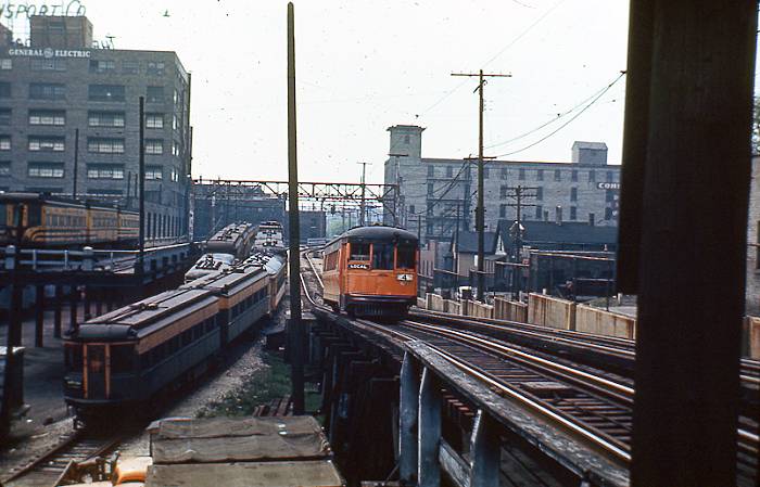
The next series of photos are from two primary websites: and. They will illustrate parts of the Milwaukee-West Junction-Hales Corners route in geographic order starting at Second Street (the end of an eastbound trip).

The trains would enter the Public Service Building into one of its six doors on Second Street and leave via the doors on Third Street. In addition, there were tracks for parking trains on the south side of the building on Everett Street. It would appear that #61 had more than its share of accidents, as evidenced by the damage along its entire right side...

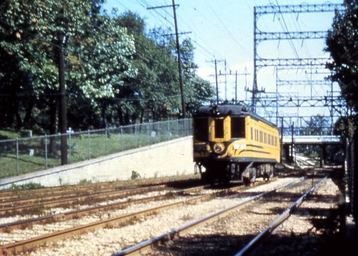
The interurban entered or exited the east end of its private ROW at the intersection of 8th and Hibernia--a short street midway between Clybourn and St Paul that was partially lost to the Marquette Interchange I-794 construction over the years. This photo from DavesRailPix.com shows a train leaving the private ROW. Except for two (1000 and 1100) blocks by Marquette University, Hibernia Street was probably just an alley. As recent as 2009, a Milwaukee business--The Literary Pit--still used the 1101 address of Hibernia Street for its official location, although it is covered by a ramp in the I-794 Marquette Interchange.
The Transport Company had its large facility to the left in this photo from TheTransportCo.com. There is an area of stark disagreement between the 1930 map and the photo of the Transport Company--the main operations facility for the interurban. According to the map, the ROW was a straight shot down due west where Hibernia would be up to 25th Street, where the ROW would cross to the south of St. Paul Street. That part might be accurate except for the east end of the ROW. The photo shows that by the 900 block of St. Paul Street, the ROW was already over 1/2 block south of the route shown on the map. And the ROW became elevated during the 900 block of St. Paul. Obviously, the ROW had to cross St. Paul above grade just after the train entered the start of the PROW at Eighth Street at Hibernia. So, a rather tight elevated S-turn would have been necessary in order for the ROW to achieve the alignment shown in the photo.
Its address was 1001 W. St. Paul, and its occupant since 1951--the prominent Aldrich Chemical Company--has to vacate it prior to its demolition around 2005 as part of the Marquette Interchange construction. The Aldrich Chemical building had stood inside and alongside of the Marquette Interchange from its start of construction in 1964. The Transport Company building spent its final 41 years (1964 to 2005) by being crowded out of existence by the Marquette Freeway Interchange construction, which was first planned during 1956 that was still undergoing in 2009! This interchange is centered on 8th and 9th Streets, so not much of any interurban infrastructure or its neighboring buildings are expected after nearly a half century has passed after its bankruptcy. Milwaukee was planning to construct its major freeway, centered on Highland Boulevard--a once fancy street, then slummy--until the interurban went bankrupt in 1951.
Then, the freeway planners snapped up the interurban ROW instead and built the first I-94 stretch from 13th to 68th Streets from 1959 to 1962. The highway department in charge of planning the freeways mentioned that the few houses still standing in the region of the ROW and Marquette University were mostly slum houses that dated back to before the Civil War, although there were also some fancy old mansions mixed among them on Wisconsin Avenue--two blocks north. Marquette University eventually owned most of the mansions afterwards and had them destroyed in order to expand its campus. Marquette also owned much of the slum houses near its campus, too, but rented them out to poor folk, mainly Mexicans, who attended Gesu parish on the campus. Having attended MU during 1961 to 1963, I did not consider the houses there to be slums, although they were old but kept up OK, AFAIK.
That train is eastbound, on approximately the 900 block of Hibernia, where it was elevated for some reason--most likely to allow pedestrian traffic to get to or from the Transport Company. It was common for interurbans to have to handle grades around 6 to 8%, something that conventional passenger trains could not do. This rapid-transit line would not have any grade crossings until it passed West Junction, several miles away in West Allis.
The 1930 map shows the route it took to enter the ROW: From the Public Service Building, it headed west on Michigan Street , then headed south one block to Clybourn Street, went west on Clybourn for 1 1/2 blocks until it turned south 1/2 block onto an alley between Seventh and Eighth Streets, and then went west 1/2 block on Hibernia (another alley, actually) before entering its private ROW.
The Milwaukee-Waukesha interuban was rapid transit from its initial start at 35th Street to 100th Street during 1928, and the stretch east of 35th Street was extended and made free of any grade crossings to Eighth Street two years later. The eastern throat of the ROW was located five blocks due west of the main terminal for the interurban--the Public Service Building between 2nd and 3rd and between Michigan and Everett a couple blocks further to the west--its private ROW). The trains entered one end of the building and exited the other (2nd and 3rd Streets).
Milwaukee has a street named West Electric Avenue. Detroit/Lincoln Park has a similarly named street that served its interurban, I was told. Did this street feed a streetcar line or other interurban? There was a West Junction somewhere on the Waukesha interurban that split off a single-line route to Hales Corners. However, I have yet to locate it.
A Mapquest aerial photo based on 5200 W Wells could be used to track the private right-of-way going N-S for about 1/2 mile for the West Allis path for the double #10 Wells streetcar line which then ran parallel (north of) to the interurban for approximately 1/2 mile or so. That right of way was directly in the middle of the block between 52th and 53rd Streets from Wells to Bluemound. Some ties still remain from that old #10 streetcar line along that short private ROW. South of Blue Mound, the ROW is essentially Zablocki Drive. You can still see the route of part of that ROW in the aerial photo.
There are still standing at least five of those four-lane-wide high-voltage towers west of County Stadium to Hawley Road that the interurban used. This photo is one among several others on the http://www.thetransportco.com/id11.html website. Two of those five original four-wide towers still stand--one on each side of the former (cutoff) Hawley Road. West of Hawley Road, I-94 did not use the interurban ROW, as it moved a bit to the south instead. Most of the interurban's power towers were since replaced, except those between the cemeteries in Wood WI--the official name given for that VA facility near Milwaukee County Stadium due to the Veteran's Administration facilities there, including their national cemetery. The presence of the various cemeteries alongside must be the only reason for keeping those few original towers.
As a freshman, I attended Marquette High, one block south of Wells and rode the #10 from 35th and Wells to Allis-Chalmers terminal in West Allis and back the final day it ran on 2 March 1958. I somehow forgot the exact route of that line, so if anybody knows anything, let me know. My take is that from its West Allis terminus, the #10 ran north right along the east side of 70th Street just parallel to and east of the sidewalk up to about W Main Street, then went east two blocks to 68th Street, and then headed north again to eventually run parallel to the interurban. However, I forget how it got from 68th Street to run alongside the interurban. The #10 Wells and the interurban had a transfer point at 68th Street--the Wells line was at grade at that time, so its passengers had to climb the stairs to meet the interurban at 68th Street.
The Wells #10 streetcar ROW still is visible in a Mapquest aerial along 70th Street between Dickinson and Main Streets. This photo from others on DavesRailPix.com is probably the short N-S stretch along 70th Street in West Allis, north of Greenfield Avenue. The houses and small businesses on the west side of South 70th Street, like the Texaco gas station in the photo, were all replaced by parking lots and newer buildings, perhaps by Allis Chalmers across the street before it went broke during the 1980s.
In 1958, Milwaukee built the second section (the first section was built a year earlier in Waukesha County) of the East-West freeway (I-94) from west of downtown (35th or 27th Street?) to Hawley Road, using essentially the ROW of the TMER&L for that segment. The 2200-ft N-S Stadium Freeway on 44th Street (or whatever it was named), directly feeding the east part of the County Stadium parking lot, was built during 1953--the same year that the stadium opened. It predated I-94 by five years as Milwaukee's first freeway. In order to allow the construction of new Miller (Milwaukee Brewers) Park, Milwaukee's first freeway had to be entirely destroyed and replaced some distance to the east...
Other 4-wide electric towers east of County Stadium are also visible on a Mapquest aerials or Google street-views, thereby marking the interurban route around 35th and 27th (Layton) Streets. Hawley Road itself was moved over a block to the west for the Hawley Road/I-94 interchange around 1958 or 1959, possibly later. The early I-94 in Milwaukee was built and opened to traffic about a mile at a time for the first few years. There were foot-high, traffic-metered stop-and-go lights (much like lights at tollway booths) up to 1961 or so at all the entrances to I-94, stopping the oncoming traffic in order to not back up the short freeway...
A bit of trivia here... The Zablocki Drive bridge that crosses I-94 immediately south of where the #10 Wells streetcar route met up with and paralleled the interurban was awarded a "Most Beautiful Bridge" award during 1961, about a year or so after that stretch of I-94 was first opened for traffic. Well, it might have been good looking once, but during 2001 a 21-inch crack was discovered in it that needed repairs, only 40 years after its construction. Furthermore, the bridge connects with a wartime-veterans' national cemetery. Its ugly rust should be removed, and the bridge should be painted as a show of respect...
Note the top of a 4-wide electrical tower for the interurban, barely visible over the left section of the bridge. A number of them are visible while driving along I-94 from Hawley Road to around 30th Street, whereas the electric power utility in Milwaukee chose to remove all of the others not directly along I-94 up to West Junction, somewhere near 100th Street and replaced them with conventional towers.
While driving along I-94, look for towers with this (or similar) type of construction. The lowest horizontal sections (if still present) would hold the 1200 VDC for the electric motors of the trains. This is what the rapid-transit portion of the interurban used when first built in 1926. So, when a four-wide electrical tower like this is spotted between 30th and Hawley Road (approximately 59th Street) along I-94, you have located both a rare relic of the interurban and its location. This particular tower is at 30th and I-94, which was added between 1927 and 1930. This is the closest such tower to the east that still is standing, as the others were either too close to I-94 or were east of 27th Street. The high-voltage lines east of 27th are now underground.
Railroad or history buffs could avail themselves of some useful Milwaukee maps in order to identify streets whose names are different today or either nonexistent. The following is a 1916 Milwaukee harbor map, showing a number of downtown industrial sites, the depths of the lake and rivers, and the elevation, based upon the elevation of Lake Michigan--581 feet above sea level. The elevation one block west of Marquette University (roughly 11th through 16th Streets E-W and between Wisconsin Avenue and Clybourn Street N-S) shows a difference in elevation of some 70 feet. Having attended Mazrquete HS and University, I never noticed such relief changes. So, those hills were probably scraped and sold as sand and gravel...
The Milwaukee terminus for the interurban was located in the Public Service Building, between 2nd and 3rd Streets and between Michigan (Sycamore, in 1916) and Everett Streets--midway between Michigan and Clybourn Streets. That location does not show up in the 1916 map, but it does in this 1923 map.
This 1923 map also shows the #10 Well-West Allis streetcar route, at least a few blocks past Hawley Road. The rapid=transit interurban from 35th Street to 100th Street is still four years in the future (first opened in 1927).
A 1930 map would prove much more useful than the earlier two for determining the routes for the interurban because by 1930, both the first phase (35th to 100th Streets) and the second phase (35th to 8th Streets, done in 1930) of the interurban are shown.
The 1930 map is in agreement as to where the Hales Corners route was sited. One website indicated that the Hales Corners route was switched at West Junction and that West Junction was located at 100th Street. The 1930 map shows that West Junction was at 100th and Burnham, which surprised me because my initial guess was that route #93 headed to Waukesha about 1 1/2 miles north of the route it did. Its route must have been very close to the ROW for the railroad track(s) there running E-W to Waukesha.
The #10 Wells--West Allis streetcar line ran considerably farther than its eventual terminus at 70th and Greenfield (former 150-acre Allis-Chalmers factory that closed during the recessions during the 1980s). The 1930 map shows that the #10 streetcar also had run a spur line to run alongside the interurban at West Junction before running further west, using the same route (and tracks?) that the interurban used west from West Junction. It would appear that the #10 streetcar route was the most versatile route in Milwaukee--covering the far East side, downtown, Wells Street in Milwaukee across the Menoninee River to Wauwatosa and various options in West Allis, including transferring to the rapid-transit interurban at Hawley Road, 68th Street, and West Junction.
The next series of photos are from two primary websites: and. They will illustrate parts of the Milwaukee-West Junction-Hales Corners route in geographic order starting at Second Street (the end of an eastbound trip).
The trains would enter the Public Service Building into one of its six doors on Second Street and leave via the doors on Third Street. In addition, there were tracks for parking trains on the south side of the building on Everett Street. It would appear that #61 had more than its share of accidents, as evidenced by the damage along its entire right side...
The interurban entered or exited the east end of its private ROW at the intersection of 8th and Hibernia--a short street midway between Clybourn and St Paul that was partially lost to the Marquette Interchange I-794 construction over the years. This photo from DavesRailPix.com shows a train leaving the private ROW. Except for two (1000 and 1100) blocks by Marquette University, Hibernia Street was probably just an alley. As recent as 2009, a Milwaukee business--The Literary Pit--still used the 1101 address of Hibernia Street for its official location, although it is covered by a ramp in the I-794 Marquette Interchange.
The Transport Company had its large facility to the left in this photo from TheTransportCo.com. There is an area of stark disagreement between the 1930 map and the photo of the Transport Company--the main operations facility for the interurban. According to the map, the ROW was a straight shot down due west where Hibernia would be up to 25th Street, where the ROW would cross to the south of St. Paul Street. That part might be accurate except for the east end of the ROW. The photo shows that by the 900 block of St. Paul Street, the ROW was already over 1/2 block south of the route shown on the map. And the ROW became elevated during the 900 block of St. Paul. Obviously, the ROW had to cross St. Paul above grade just after the train entered the start of the PROW at Eighth Street at Hibernia. So, a rather tight elevated S-turn would have been necessary in order for the ROW to achieve the alignment shown in the photo.
Its address was 1001 W. St. Paul, and its occupant since 1951--the prominent Aldrich Chemical Company--has to vacate it prior to its demolition around 2005 as part of the Marquette Interchange construction. The Aldrich Chemical building had stood inside and alongside of the Marquette Interchange from its start of construction in 1964. The Transport Company building spent its final 41 years (1964 to 2005) by being crowded out of existence by the Marquette Freeway Interchange construction, which was first planned during 1956 that was still undergoing in 2009! This interchange is centered on 8th and 9th Streets, so not much of any interurban infrastructure or its neighboring buildings are expected after nearly a half century has passed after its bankruptcy. Milwaukee was planning to construct its major freeway, centered on Highland Boulevard--a once fancy street, then slummy--until the interurban went bankrupt in 1951.
Then, the freeway planners snapped up the interurban ROW instead and built the first I-94 stretch from 13th to 68th Streets from 1959 to 1962. The highway department in charge of planning the freeways mentioned that the few houses still standing in the region of the ROW and Marquette University were mostly slum houses that dated back to before the Civil War, although there were also some fancy old mansions mixed among them on Wisconsin Avenue--two blocks north. Marquette University eventually owned most of the mansions afterwards and had them destroyed in order to expand its campus. Marquette also owned much of the slum houses near its campus, too, but rented them out to poor folk, mainly Mexicans, who attended Gesu parish on the campus. Having attended MU during 1961 to 1963, I did not consider the houses there to be slums, although they were old but kept up OK, AFAIK.
That train is eastbound, on approximately the 900 block of Hibernia, where it was elevated for some reason--most likely to allow pedestrian traffic to get to or from the Transport Company. It was common for interurbans to have to handle grades around 6 to 8%, something that conventional passenger trains could not do. This rapid-transit line would not have any grade crossings until it passed West Junction, several miles away in West Allis.
The 1930 map shows the route it took to enter the ROW: From the Public Service Building, it headed west on Michigan Street , then headed south one block to Clybourn Street, went west on Clybourn for 1 1/2 blocks until it turned south 1/2 block onto an alley between Seventh and Eighth Streets, and then went west 1/2 block on Hibernia (another alley, actually) before entering its private ROW.
The Milwaukee-Waukesha interuban was rapid transit from its initial start at 35th Street to 100th Street during 1928, and the stretch east of 35th Street was extended and made free of any grade crossings to Eighth Street two years later. The eastern throat of the ROW was located five blocks due west of the main terminal for the interurban--the Public Service Building between 2nd and 3rd and between Michigan and Everett a couple blocks further to the west--its private ROW). The trains entered one end of the building and exited the other (2nd and 3rd Streets).
Milwaukee has a street named West Electric Avenue. Detroit/Lincoln Park has a similarly named street that served its interurban, I was told. Did this street feed a streetcar line or other interurban? There was a West Junction somewhere on the Waukesha interurban that split off a single-line route to Hales Corners. However, I have yet to locate it.
Last edited by Detroit on Wed Jun 24, 2009 5:14 am, edited 64 times in total.
Anyone know if the A, B and C markers on the map below are part of the old T.M.E.&L.Rwy line to Burlington, Wi?
Also, any other traces of the Milw Electric Burlington line?
http://mapper.acme.com/?ll=42.68982,-88 ... ngton%20WI
Also, any other traces of the Milw Electric Burlington line?
http://mapper.acme.com/?ll=42.68982,-88 ... ngton%20WI
Bring back the Slumbercoaches!!