Railroad Forums 

  • The SIRR and RVRR V

  • Discussion about the M&E, RVRR and SIRR lines of New Jersey, and also the Maine Eastern operation in Maine. Official web site can be found here: www.merail.com.
Discussion about the M&E, RVRR and SIRR lines of New Jersey, and also the Maine Eastern operation in Maine. Official web site can be found here: www.merail.com.

Moderators: GOLDEN-ARM, cjl330, mikec

 #157901  by rvrrhs
 
CJPat wrote:Was the passing siding set up to service the Springfield Station (like the siding that serviced the RRRR freight house in Millstone)? This could allow through trains while freight cars were offloaded at the freight house.
No, the siding began about 100-200 feet east of the Springfield station, heading further east away from the station.

CJPat wrote:Was there any stations for Union or Summit?
Actually, from way back when the RVRR ran passenger service up until around WWI, there were stations in Roselle Park (now the site of Sunset Tavern on North Ave.), Kenilworth of course, a farm stop near what's now the Rt. 22 crossing, a stop at Farcher's Grove (now Duerr Plastics) in Union, a stop between what is now the Ideal Office Park and Vauxhall Rd. in Union, a station for Baltusrol where I-78 crosses the ROW, and a station in Summit just east of the junction with the DL&W. Some of these survived for years as freight depots or were rented as commercial property.

For photos of some of these, check out http://www.trainsarefun.com/rvrr/rvphotos.htm

 #157987  by mikec
 
Roselle Park (now the site of Sunset Tavern on North Ave.),

This is the location of the 2nd Aldene station which was owned by the CNJ. I think Passenger service on the RV ended by this time. The 1st CNJ Aldene station was just east of the LV this in the one you see the RV using This also shows up as a stop on the LV timetables that I have seen.

 #158038  by mikec
 
http://www.trainsarefun.com/rvrr/images/aldenerr.jpg

This is a Pic of the 1st Aldene Station the Bridge LV over Westfield Ave can be seen in the background. This is about 400 yards East from the Sun Taven which is the site on the 2nd Aldene Station

 #158052  by CJPat
 
There is something I don't understand about the CNJ/RVRR Aldene Railroad Station shown on the postcard.

If the postcard is accurate and that is Westfield Ave (North Ave) in the background with the LVRR bridge that crosses diagonally over the CNJ, that means the direction of the artist's view is northwest (the station would appear to be on the east side of the Lehigh Valley and north side of the CNJ), then the station would be located on the site that is occupied by the old factory (I think it last processed rags and looks like it dates back to the 1910-1920 period) that stretches between the LVRR and Gordon St.

The Rahway Valley departed the CNJ to run north approximately 4 blocks (400-500 ft?) west of the station through what is/was the Horan Lumber yard. How would that support passengers for the RVRR? Maybe there was a Wye leg at the Horan Lumber location that turned the RVRR east on the CNJ? Since the 1970's, I have only seen the RVRR leg that puts trains in a west direction of the CNJ.

If that was actually 1st Ave (South Ave) in the background, then the station was on the south side of the CNJ and at the east end of the old CNJ/B&O/SIRT interchange yard. The RVRR would now only be about 100 ft west of the station. This still isn't properly placed to support passengers for RVRR.

Anybody have a good way to explain the placement of the Aldene station that makes sense? How would an RVRR passenger train (granted, a small train) access that station without doing several reverse moves to reach the station?

 #158065  by Ken W2KB
 
The perspective does look like that is South Avenue. Perhaps the RV passengers simply crossed the CNJ mainline to/from the station?

 #158114  by mikec
 
Older track configs do show the RV swinging east not to the west If you have seen some the tickets they exchange at Roselle/ Roselle Park which is one station east of Aldene. The road in the background is Westfield Ave not 1st/south Ave. This Aldene station was on what is now part of the Romoroski Property

 #158169  by Don Maxton
 
Regarding the postcard of the Aldene station on the trainsarefun web site. This appears in my book, and I always thought that this was the first Aldene Station. MikeC, can you refer me to a map that shows the location of the first Aldene Station? I didn't find anything like that in my research.

There's another photo in my book showing what is obviously the same station as in the postcard, with two locomotives. It's difficult to tell, but I think one of them is CNJ and the other Rahway Valley. Can anyone confirm that?

The postcard may be earlier than 1928, and RVRR passenger service ended about 1918--1920. They ran some mixed trains up to that date.

 #158182  by mikec
 
I don't remember were I saw it I think it was a Map of the LV showing Aldene as a stop way back when Pass. Service still ran on the LV. I will look and see if I can find it again.

 #158203  by Don Maxton
 
Thanks, Mike, that would be great. Hope you can find it. I plan to do a followup book and would like to make some corrections from the first one.

 #158239  by mikec
 
I know this area very well. And for a long time I was confussed about this picture of the 1st station. If it was at the site of Sun Tavern. Then could have been South ave in the background. But if that was true then the Station would have been on the Roselle (south) side of the tracks. Then I saw a later picture 1st station I think in your book or the Hist of Roselle Pk Book. This newer picture shows the outside porch of the station enclosed and a Large Radio tower right next to it. Romoroski's Bros is a site of a old Marconni Radio station. I think from what I can tell about these pictures is that the 1st Aldene station was located Just east of the LV facing south and the LV bridge in the background is crossing Westfield not south ave. Which places the 1st and 2nd Aldene stations about 4/10 of a mile apart. I think the RV might have swing in both directions East and West onto the CNJ. If I find out any more about this I will post it.

Link about the radio station

http://www.nrcdxas.org/articles/hmr0696.txt

 #158328  by CJPat
 
OK, I think I have a handle on the Aldene station issue. I used my copy of Jersey Central Steam In Color, by Bert Pennypacker as a reference. I would say the postcard is looking at the Aldene station on the eastbound side of the CNJ tracks with 1st avenue in the background.

Although there were no direct pictures of the Aldene Station in the book, there were several pictures taken from the Aldene Station platforms as well as one or two long distance photos with the station in the background. The photos I am referencing were taken in/around 1946.

From what I can piece together, The CNJ/RVRR Aldene station had structures on both side of the CNJ tracks and was located on the WEST side of the Lehigh Valley fly over. The station had a pedestrian bridge connecting the two sides and a wrought iron fence running down in between the center of all the tracks to prevent passengers from trying to cross over (forced passengers to use the pedestrian bridge). From what I can gleen, the CNJ had 4 through tracks coming from the east with a switch immediately west of the LV bridge and east of the westbound station platform that created a 5th track. Just before the pedestrian bridge, the 5th track had another switch and I am guessing that this track is the beginning of the RVRR interchange and ran behind the westbound Aldene Station and then turned north towards Kenilworth.

This was definitely a complicated area. Immediately to the west of the Aldene Station would have been the entrance to the Cranford CNJ/B&O/SIRT interchange yard which was off on the southside of the CNJ main and was quite large (looks to be 1/4 mile-1/2 mi long and 10 tracks wide, not counting the CNJ main). And of course there was the Cranford engine facilities with their roundhouse, coaling dock, and water tower all immediately to the west.

So you had the RVRR, the CNJ, the B&O, and the LV all running through a very small area. I grew up in the area between late 1960 - 1985 and had no clue how extensive this area really was in its prime. I wish I could have seen it around 1950. After the railroads began their rapid decline in the1960s and the Aldene Plan was put into effect (1968?) and the ramp from the LV down to the CNJ was put in, it removed any trace of the Westbound Aldene Station area and pedestrian bridge. Traffic on the B&O/SIRT line was drying up and most of the interchange yard was ripped up. That property was completely sold off to industrial/commercial interests.

At that point, the RVRR evidently was only left with a little used connection to the CNJ westbound through Horan Lumber and their main connection on the other side of Aldene to the LVRR (completely lost to redevelopment when the RVRR was abandoned in the early '90's).

 #158335  by CJPat
 
I made a slight error. There were 5 tracks coming from the east approaching the Aldene Station (3 westbound and 2 eastbound) with a switch creating 6th track immediately west of the LV on the westbound side. One more switch before the pedestrain bridge creates a7th track which appears to bend off behind the westbound station and is probably the interchange with the RVRR.

 #158506  by mikec
 
If you look in CNJ in color there is picture of the 2nd aldene station this I know for sure was at the site of Dunn's Garage now Sun Traven. But the picture in the post card is a older station. I wish I could fine this later one in digial format is a real picture not the like the post card. I can see what I think is Warren ave in the background dumping out onto Westfield ave Also there is a a hugh radio tower right next to it. The Dunn location is to far from the radio station to be the location of this tower.

 #158561  by rvrrhs
 
CJPat wrote:There is something I don't understand about the CNJ/RVRR Aldene Railroad Station shown on the postcard.

If the postcard is accurate and that is Westfield Ave (North Ave) in the background with the LVRR bridge that crosses diagonally over the CNJ, that means the direction of the artist's view is northwest (the station would appear to be on the east side of the Lehigh Valley and north side of the CNJ), then the station would be located on the site that is occupied by the old factory (I think it last processed rags and looks like it dates back to the 1910-1920 period) that stretches between the LVRR and Gordon St.

The Rahway Valley departed the CNJ to run north approximately 4 blocks (400-500 ft?) west of the station through what is/was the Horan Lumber yard. How would that support passengers for the RVRR? Maybe there was a Wye leg at the Horan Lumber location that turned the RVRR east on the CNJ? Since the 1970's, I have only seen the RVRR leg that puts trains in a west direction of the CNJ.

If that was actually 1st Ave (South Ave) in the background, then the station was on the south side of the CNJ and at the east end of the old CNJ/B&O/SIRT interchange yard. The RVRR would now only be about 100 ft west of the station. This still isn't properly placed to support passengers for RVRR.

Anybody have a good way to explain the placement of the Aldene station that makes sense? How would an RVRR passenger train (granted, a small train) access that station without doing several reverse moves to reach the station?
I've looked at the 1928 postcard. I've looked at a topographic map of Aldene Junction and a relief map of the RVRR. I even looked at some RR and municipal maps of the RV's southern connections.

So, here's what I can see:
#1. The RV's interchange with the LV just west of the Roselle Park station led into a small yard, with no direct connection to the LV itself. For an RV train to get onto the LV line, it would have to enter the yard moving eastbound, and then back westbound onto the LV. http://www.trainsarefun.com/rvrr/images ... 20plan.gif
#2. The RV's interchange with the CNJ at one time was eastbound to connect with the CNJ station(s) in Roselle http://www.trainsarefun.com/rvrr/images/cranjunc.gif, and later (after the Aldene Plan, I suppose) westbound through a small yard http://www.trainsarefun.com/rvrr/images/crjct.jpg. So, at one time the RV tracks came south across Westfield Ave. and turned east toward the Aldene station. That is, "The Aldene Plan also relocated the trailing point (westbound facing) Rahway Valley connection to the CNJ to a facing point eastbound switch," to quote one source. The point where the RV used to join the CNJ heading eastbound is now buried beneath the Aldene Plan ramp.
#3. On the topo map, there's a large building to the east of the LV, just north of the CNJ http://www.trainsarefun.com/rvrr/images/cranjunc.gif. This is Romerovski, the former site of the station in the postcard (west end of the Romerovski site) and the Marconi/GE radio factory and tower (east end of Romerovski). The Marconi radio tower was at this site until at least 1921, per the Roselle Park historian http://www.rosellepark.org/upclose/history/history.htm, while Romerovski was founded in 1946, according to the company's homepage http://www.romerovski.com/lngEnglish/default.asp. So, if Romerovski built that factory themselves, presumably in 1946 or afterward, the station and radio tower were likely still on that site until perhaps sometime during World War II.
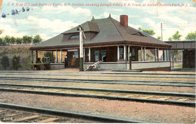
#4. In the postcardhttp://www.trainsarefun.com/rvrr/images/aldenerr.jpg, the CNJ is in the foreground, and the LV is in the background--farther away on the right, nearer on the left. Therefore, this shot is looking north from the south side of the CNJ mainline. The road is in fact North Ave./Westfield Ave. To the left is west towards Cranford; towards the right is east towards Elizabeth. The RV connected to the CNJ west of this site, heading eastbound, so the RV was somewhere beyond the LV bridge, straight ahead of the camera.
  • 1
  • 34
  • 35
  • 36
  • 37
  • 38