Railroad Forums 

  • The Old NYC Peanut Line.

  • Pertaining to all railroading subjects, past and present, in New York State.
Pertaining to all railroading subjects, past and present, in New York State.

Moderator: Otto Vondrak

 #1165194  by SST
 
You're right about the main line row. It has been paved over for many years. I don't even think there are rails in the ground that are paved over. I seem to recall something about that area in regards to paving it over and updating the signals. The last time I lived in the area was 1994.
 #1165925  by ScotCP356
 
Last night, I decide to follow the old peanut line from Canandaigua to Holcomb (or East Bloomfield) and then follow the old path from Holcomb to Caledonia. I found it interesting that the Peanut Line was also near the tracks of other railroads. Especially in Caledoina, where there is the LV and B&O. Probably even the G&W? It mostly found the line near the other lines at the Caledonia LeRoy Road or Route 5 crossing in the town of Caledonia, where I found the old diamond, don't know if that belong to the peanut or not. I see that there is at least maybe 2 or 3 different railroads. It's interesting but great to learn about the railroad past in Western New York! But now back to the Peanut line, I lost the path after leaving Caledonia. I couldn't find the path. But I will try again or find a railroad map of it later this evening or tonight!

-Scottie
 #1165933  by BR&P
 
You said you lost the ROW after Caledonia - I'm guessing you meant continuing west? From P&L Jct to Leroy there were three ROW's side by side - the Erie on the south, the NYC in the middle, and BR&P / B&O on the north. At Leroy the Peanut crossed the BR&P so crossing Rt 19 in Leroy the NYC was the north-most track as it headed (eventually) for Batavia.

If you go to about Lime Rock and take a side road north off Rt 5, use the present day Rochester & Southern as a reference, that's the old B&O. Look just south of that and you'll find traces of the other two lines.
 #1165938  by ScotCP356
 
Yes I lost the ROW heading west. I will check it out again later tonight. I know where the B&O once was. I follow that old line once or twice. Thank you for the information!


-Scottie
 #1165940  by ScotCP356
 
lvrr325 wrote:You can follow it fairly easily on Google Maps.
That what I used last night to follow the Peanut Line. Thanks!


-Scottie
 #1166164  by RussNelson
 
Dude, get yourself an Android phone or tablet (the cheap tablets don't have GPS -- get a Nexus 7). Doesn't have to have a data subscription, just wifi will do. Then from the Play Market, install OSMAnd. Then, while you're still online, run the program, visit the settings, and download offline maps of New York State. Every railbed in New York State is in the map, AND the GPS will show you your location relative to the railbed.

You can pick up a Nexus 7 for $200. OSMAnd costs $7 or something like that. No fees to be paid beyond that. And you'll *always* know where the railbeds are.
 #1166262  by ScotCP356
 
You know what's ironic, I do have a Nexus 7. It's the only way I can check all my email and other stuff. I make sure I get the app.
 #1166928  by s4ny
 
I remember the NYC (Peanut) tracks in Caledonia just south of the LV overpass.
I also remember the abandoned overpass south of Rush on NY15A.

In the middle 1850s the NYC Peanut was part of a connection for the Erie to get passengers
to Niagara Falls from Elmira and points east.

The Canandaigua and Niagara Falls RR was the first line in Honeoye Falls and the
Lima and Honeoye Falls RR was built in 1892 to connect with that line (and the LV).
This Lima line went right into the village of Lima and I recall the long abandoned
route was marked by a line of electric poles running through a field west of NY15A.
 #1172979  by SST
 
JoeS wrote:On the west end, the Peanut Line terminated at the interlocking "Erie 3" which is on the old NYC Niagara Falls branch just south of the Tonawanda Creek/Barge Canal drawbridge.

There is a short remnant of trackage remaining between the interlocking and Wales Ave. in Tonawanda, however I think the Wales grade crossing is paved over.

This track was also used by the LV for trains on their Niagara Falls branch; traveling east from Wales Ave. the LV branched off the Peanut to the right at Tonawanda Jct. There is an unnamed road from Creekside Dr. to a water treatment plant, that passes right over the location where Tonawanda Jct. once stood.

From this point the Peanut ran east along the north edge of Ellicott Creek Park, crossed Niagara Falls Blvd. (south edge of St. Christopher parking lot) and was pretty much a straight track to near Akron Jct. where it crossed the West Shore.
While driving around checking out the high water I ended up in Tonawanda following Ellicott Creek which brought me to Tonawanda JCT. As stated in other posts, I haven't checked this area out since 1994. At that time, the Peanut was heavily overgrown with brush. Can't even see it. The LVRR was walkable. The Peanut was paved over for access to the treatment plant. None of the treatment plant interferes with either ROW from Ellicott Creek Rd to Ellicott Creek Dr. accept for the treatment plant access rd.

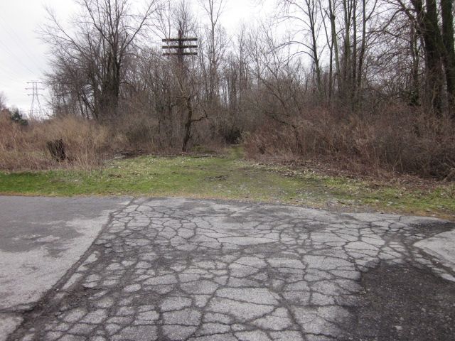
When I pulled off onto the access rd yesterday, it was clear that nothing has changed in 20 years. I also think that rails may exist underneath the road. It has the look.

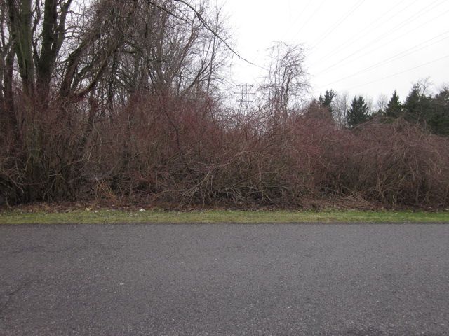
This picture is looking east from the access road. The Peanut is under heavy brush and you can't really see it. The LVRR line bends off to the right. It appears the same as 20 years ago. I didn't walk down it with all the heavy rain. Another time.
Image

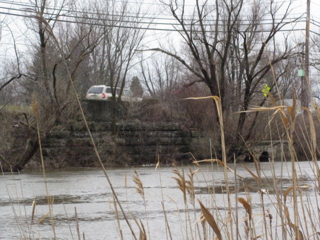
This picture was taken from Ellicott Creek Park looking SW. This is the LVRR crossing of Ellicott Creek. There was a path from the park towards the ROW but it was underwater due to heavy rain.
Image

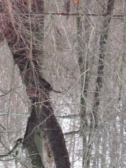
This picture is from inside the park as well. It is up against the ROW. I was surprised that I could see the ROW. But when the leaves grow, you won't see anything of either ROW. This is one of a few remaining LVRR telegraph poles still standing with wire attached.
Image

This last picture is just outside the fence on the north side of the park. I am sitting on the Peanut ROW looking west. If you didn't know this was a RR, you'd never now it was here. It is very thick with overgrowth. This section is far worse than out in Clarence before the new trail.
Image

This are is worth re-exploring after it dries up a bit and before the leaves grow.
 #1173418  by JoeS
 
Nice pictures!

The second-to-last pic brought back old memories: in the early 1960s my grade school class had a picnic in Ellicott Creek Park. Guess where I spent a lot of my time? Right at that fence, watching the trains roll past.

That day I also remember seeing the signals at the Junction, which were upper-quadrant semaphores if memory has not failed me. I believe the westward signals on the Peanut were still in place although the tracks heading east had been pulled up by then.

I suppose the semaphores were taken out a few years later when the LV single-tracked the branch and installed searchlights. I wonder if the old signal pedestals are still there, in among the weeds.
 #1173953  by sd80mac
 
charlie6017 wrote:In my copy of an NYC ETT from 1965 it reads:

Canandaigua & Holcomb, inclusive:

All trains....................20
Wrecking trains handled in wrecking service.........15
Bridge P-7, MP 6...............15

Charlie
what.... a... slow... ride!!!!

heck! your GF or your family could hustle out of station in their cars and give you 2 or 3 good bye waves within town of Canandaigua... and maybe one more at Holcomb..
 #1173981  by ScotCP356
 
I don't know if I ask this question or not, but what types of steam locomotives would the New York Central use on the Peanut Line? I'm thinking maybe switchers for freight and small engines for passenger trains? But I don't know, I see some images had small steam engines as switchers and passenger but don't know if that all they use on the line. Some information will be nice please! :(

I also want to say thank you for all the information about the Peanut Line and some information about the Auburn Route! This really does helps me to get to know the line very well indeed!! Keep on posting more information about the Peanut Line and even about the Auburn Route!! That would great if I know both lines!! Thanks!! :-D


-Scottie
 #1173985  by charlie6017
 
sd80mac wrote:
charlie6017 wrote:In my copy of an NYC ETT from 1965 it reads:

Canandaigua & Holcomb, inclusive:

All trains....................20
Wrecking trains handled in wrecking service.........15
Bridge P-7, MP 6...............15

Charlie
what.... a... slow... ride!!!!

heck! your GF or your family could hustle out of station in their cars and give you 2 or 3 good bye waves within town of Canandaigua... and maybe one more at Holcomb..
Yeah, I can imagine. This was well before my time, but I would think by this time this route was nothing more than just local business
and was maintained just enough to serve the few customers it had.

To attempt an answer for ScotCP356, I would guess yes. But I'm sure there are others on here much more qualified than myself to
give a more specific answer.

Charlie