The East Peanut was originally the Canandaigua and Niagara Falls Rwy. Constructed in the mid-1800s if recall is correct. The NYC purchased the line in the late 1800s, again if memory serves correctly.
The line was abandoned thus:
Holcomb-Caledonia, 23.15 miles, 14 January 1939
North Tonawanda-Transit, 9.35 miles, 1956
Brixment-Akron Jct., 1.78 miles, 1961
Batavia-Pembroke, 12.82 miles, 1962
Transit-Getzville, 3.56 miles, 1963
Canandaigua-Holcomb, 8.07 miles, 1972
Batavia--P&L Jct. February, 1975.*
Akron Jct.-Transit, 8.6 miles, 07 January 1978
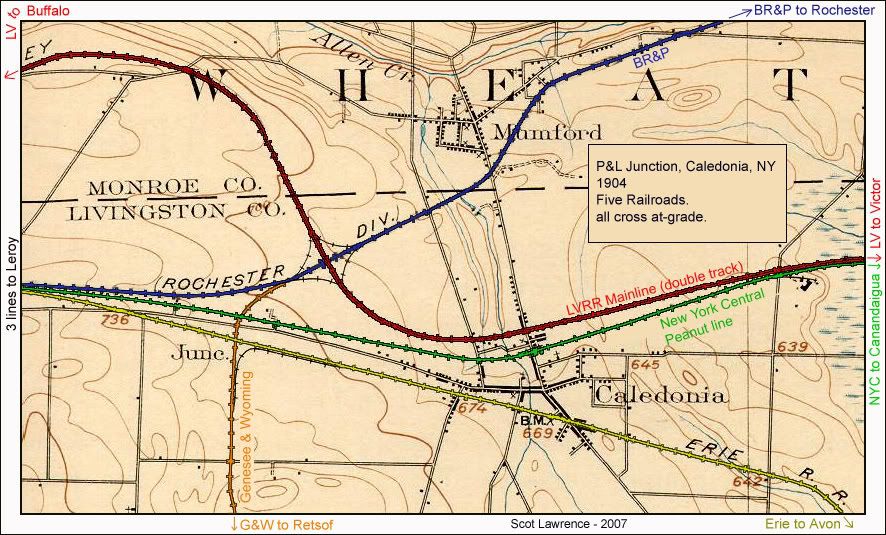
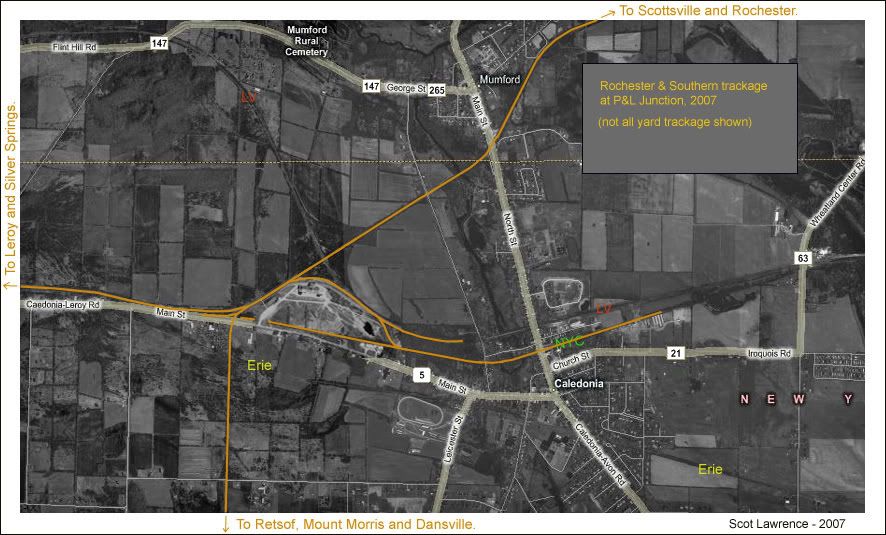
Another segment of the East Peanut survives. It is used by the Rochester & Southern from P&L Jct. to Jones Chemical in Caledonia. The R&S refers to this segment as the Jones Chemical Spur.
* Segment from CSX CP402 to the Lehigh Switch, .75 miles, is utilized by GVT.
The line was abandoned thus:
Holcomb-Caledonia, 23.15 miles, 14 January 1939
North Tonawanda-Transit, 9.35 miles, 1956
Brixment-Akron Jct., 1.78 miles, 1961
Batavia-Pembroke, 12.82 miles, 1962
Transit-Getzville, 3.56 miles, 1963
Canandaigua-Holcomb, 8.07 miles, 1972
Batavia--P&L Jct. February, 1975.*
Akron Jct.-Transit, 8.6 miles, 07 January 1978
Another segment of the East Peanut survives. It is used by the Rochester & Southern from P&L Jct. to Jones Chemical in Caledonia. The R&S refers to this segment as the Jones Chemical Spur.
* Segment from CSX CP402 to the Lehigh Switch, .75 miles, is utilized by GVT.
Last edited by TB Diamond on Tue Mar 19, 2013 10:01 pm, edited 3 times in total.
You can't go home again- Thomas Wolfe
