Railroad Forums 

  • The New Egypt & Farmingdale Railroad?

  • Pertaining to all railroading subjects, past and present, in New Jersey
Pertaining to all railroading subjects, past and present, in New Jersey

Moderator: David

 #1403656  by GSC
 
The New Egypt & Farmingdale Railroad? Where the heck was that?

Chartered in March of 1869, the railroad was to run between named towns. It never turned a shovelful of soil, and the charter was amended for the line to run between Farmingdale east to Asbury Park (the location of today's Bradley Beach freight yard on the NY&LB / NJCL.) Some grading was done - it is today's "valley" walking trail of Shark River Park, along the Wall and Neptune borders, between Schoolhouse Road and Remsen Mills Road.

More charter amendments were made, and the New Egypt & Farmingdale RR was built south 8.3 miles from Cedar Ave. in Long Branch to Ocean Beach (Belmar) in 1876.

The "New York and Long Branch RR" was chartered to build just to Long Branch, opening in 1875. Grading and other preparations were underway during this time, and in 1876, the NE&FRR opened and was leased to the CNJ-controlled NY&LB.

A wood trestle was built to span the Shark River into Belmar. Navigation upriver was then blocked due to the design of the trestle. It remained that way until 1909, when the drawbridge was installed, opening up the river to water traffic once again.

The three additional lines built farther south until Bay Head was reached were later absorbed into the NY&LB. They were the Long Branch & Sea Girt RR, the New York & Long Branch Extension RR (to Point Pleasant), and the Long Branch & Barnegat Bay RR (to Bay Head).
 #1404719  by CharlieL
 
Did not the LB&BB continue on down the peninsula to Seaside, or was that done later by the NY&LB for summer traffic?

I remember remains of a trestle across the salt marsh at the end of the Bay Head terminus (Twilight Lake), and my son was doing construction work in the Mantoloking area to repair Sandy damage, he mentioned them finding railroad spikes and rail bed plates when they dug.

Also there was mention in the AP Press of a sea wall built by "the railroad" which was uncovered by Sandy.

Was also told that when rte 35 was split (early 60's?) from South Mantoloking to the Seasides, the southbound portion was built on the old rail bed.

I was preoccupied with Uncle Sam about the time 35 was split so don't really remember hearing anything about that at the time.

Can anyone clarify? I believe the line served passenger excursion traffic and not much else and was abandoned after storm damage in '38 and or '44.
 #1404742  by TOMSTV1
 
]Image 
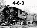
The line from Seaside to Bay Head was built around 1881,and ran up until around 1946, as that was the year that the trestle across the Barnegat bay burned. The above picture shows the NY&LB, going down the center of what is now RT-35. Soon after the tracks were removed in the fall season of 1949. There are still rails in the ground at Bay Head that head toward Twilight Lake, that were not removed.
 #1404827  by snavely
 
The line south of Bay Head was the Pennsylvania Railroad, not the NY&LB. It crossed the bay in Seaside Park and continued to Philadelphia, with a spur across the Toms RIver to Island Heights. That spur was eventually removed and its; swing bridge over the river was sold to Ocean County and moved to Beaver Dam Creek, where it carried Beaver Dam Road between Point Pleasant and Brick until about ten years ago when it was finally too worn out and was scrapped and replaced by a new drawbridge.
 #1404833  by CJPat
 
Those are magnificent photos! I have never seen any pics before regarding the run down to Seaside Pk.

As I understood it, Bay Head was a junction because the NY& LB terminated at Bay Head (that was as far as the Jersey Central ran) where the Pennsy joined it (Yes, the Pennsy was also part owner of the NY&LB). It was strictly the Pennsy south of Bay Head.

The Pennsy ran shore bound trains from Phila east through Mt Holly, Browns Mills, Whiting, Beachwood, Ocean Gate, and out across the Barnegat Bay to Seaside Park where it turned North, ran up the barrier island & officially terminated in Bay Head, although the Pennsy ran trains up the NY&LB to....(was it Red Bank?).

The line was languishing through the 'late '30's and early '40's. A lot of money was needed to maintain the Barnegat Bay bridge, the runs across the bogs to the west and the run north along the barrier island operational (most traffic was only during the warmer months). The Pennsy wanted to end the line running east at, I think, Beachwood. I believe the Pennsy also had a spur from Beachwood over another bridge across the Toms River to Island Heights (A Methodist Encampment at the time). I am not sure at what point the run to Island Heights, along with the Toms River Bridge, was removed.

Evidently, while pushing the issue to gain permission to abandon the run east to Seaside Park, a suspicious fire broke out in the winter of '46 and permanently put the bridge out of commission gaining the Pennsy just cause and reason to finally obtain permission to officially cut the line on the west side before the bridge and stop all movement east (the next westward cut came when they built the GSP over the top of the Pennsy ROW and the Pennsy than terminated at the the freight house just on the west side of Exit 81. I think the GSP cut was sometime around early '60s.

I believe the Pennsy continued to run some sporadic trains south from Bay Head to Seaside Pk during the summer months until 1948 or 49 and then terminated the southerly run at Bayhead never to run across Twilight lake again.

Not sure about the history of cutting of the line between Browns Mill thru Whiting to Beachwood/Toms River and when those tracks were pulled. I guess service now terminates in Mt Holley?

You can follow the Pennsy ROW east from Exit 81 out across to Ocean Gate if you look at the Bird's Eye View of any map program. Just start at Exit 81 and the GSP/Rt9 Access Road and follow out toward Beachwood (Pennsylvannia Ave-the spur to Island Heights began at Station Ave) continue east from Pennsylvania to Atlantic Ave and across the bog (you can easily see the old ROW) to where it crosses Cnty 617 just south of Pier Ave. There is a restaurant there with a long jetty behind it (this was the jetty for the railroad to enter the bridge across the bay. The Pennsy Bridge ended at 14th Ave and ran east to where it had a station as it turned north up what is now Rt 35.

If you look west from Exit 81 on the GSP (on the Bird's Eye view, you can easily see the ROW heading back to Whiting (Junction) and Browns Mills and eventually over to Mt Holley where the active track is still today.

Hopefully someone with more concrete knowledge can correct my errors.
 #1404852  by TOMSTV1
 
The Island Hts. bridge was removed in 1935, the Parkway was being built around 1954-55 in that area. The line from Whiting west to Browns Mills area was removed around 1967.
The remaining track from Pemberton to Mt. Holly was removed around 1969. The line is still there across Madison ave. from the Mt. Holly Station, witch is still there today. as is the North Pemberton Station too. The line was the Pemberton line, it's now the Hainesport line, that goes to Camden & Philly. There are still rails in the ground at Bay Head from the Seaside line.
 #1405197  by GSC
 
Those are some great pics!

The line west of Whitings was once owned by the NJ Southern. Pennsy acquired the line and extended it eastward to Toms River, and then to Seaside and to Bay Head, opening in 1881. There was enough Pennsy traffic to Long Branch to require a second line from the Camden / Philly area, the other line being the Freehold & Jamesburg. There were plans to double-track the F&JA!

Would love to see traffic like that today.

When the Barnegat Bay trestle burned in December 1946, it was about four days after the Matawan Creek trestle on the NY&LB burned! Can you say "hmmm"?

NY&LB traffic was forced to re-route via the Freehold & Jamesburg from Sea Girt and the Freehold Branch from Matawan to bypass to Jamesburg, and up the Camden & Amboy to South Amboy. Pennsy and CNJ teamed up to make this happen, trains from both carriers using both companies' lines.

The Matawan Creek trestle was rebuilt, but the Barnegat Bay trestle was abandoned.

These suspicious bridge fires are worthy of a thread of their own.
 #1411173  by GSC
 
"Progress" caused these rail lines to go away. Today's "progress" could use their return.

So much science fiction and futuristic movies and books all seemed to include people movers in the overcrowded cities. I think they were on to something.
 #1411174  by GSC
 
To answer an earlier question from above, The Long Branch & Sea Shore (two words) was originally planned to run south from Sandy hook through Long Branch and then on to Manasquan, Toms River, and Tuckerton. In its day Tuckerton was quite an important seaport. During the Revolution, Tuckerton was the third most important seaport, after New York and Philadelphia, and ahead of Baltimore and Boston.

Early rail charters showed FOURTEEN possible routes to Tuckerton!

If you can get a copy, John Brinckmann's "The Tuckerton Railroad" is priceless with this information.
 #1411318  by R&DB
 
Tuckerton was a Port of Entry into the U.S. and it's value was that the sailing ships could not get up the ice choked Delaware River to Philly in winter. The ships would dock in Tuckerton and passengers would take a stage (and later a train) across to Philly.