Railroad Forums 

  • Tamaqua Hazleton and Northern (THN)

  • Discussion Related to the Reading Company 1833-1976 and it's predecessors Philadelphia and Reading Rail Road and then the Philadelphia and Reading Railway.
Discussion Related to the Reading Company 1833-1976 and it's predecessors Philadelphia and Reading Rail Road and then the Philadelphia and Reading Railway.

Moderator: Franklin Gowen

 #452280  by pumpers
 
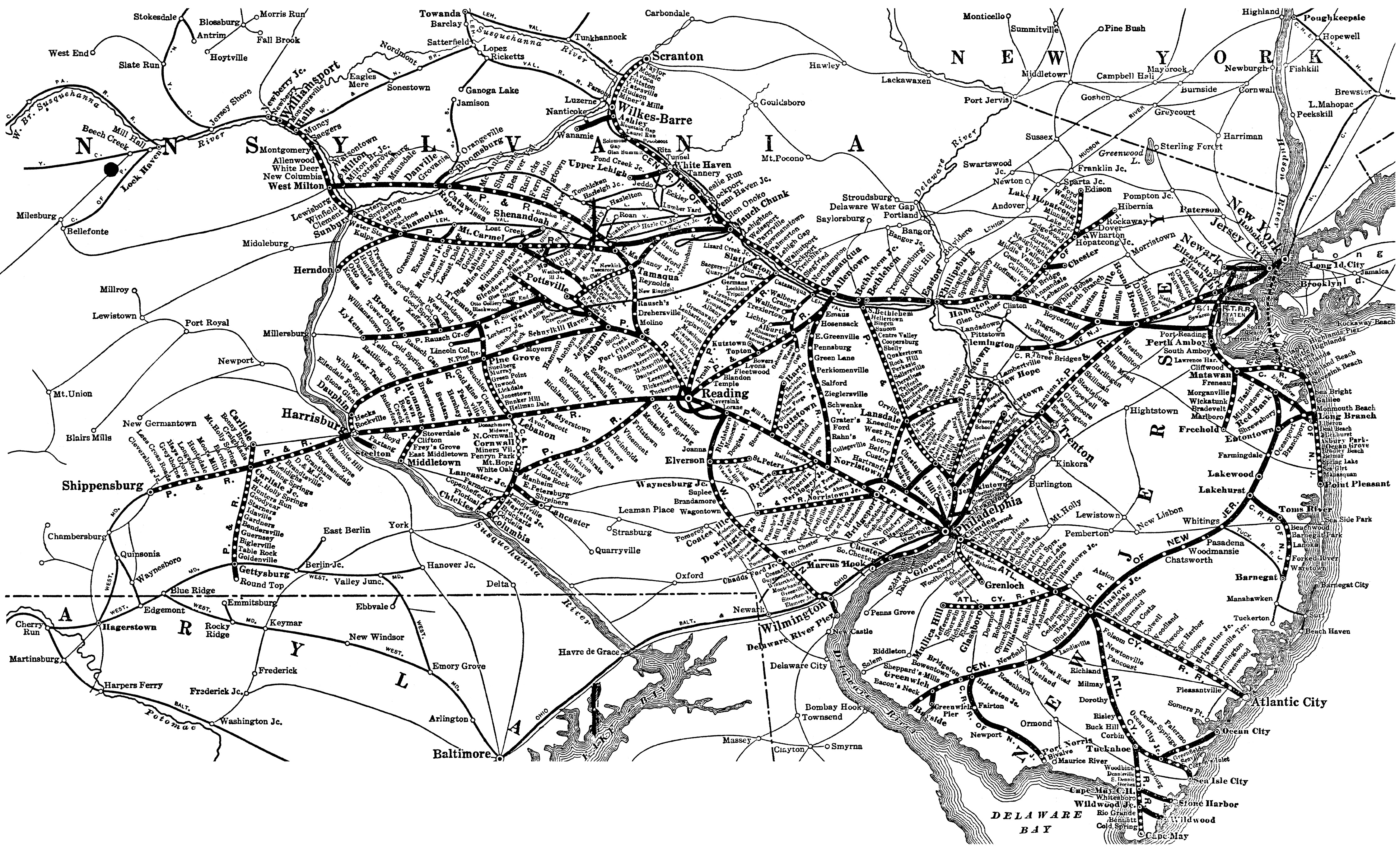
THis was a relatively short-lived Reading line from the Catawissa line at Hazelton Junction (near Lofty a bit north of Quakake, north of Tamaqua) connecting to up near Hazleton (specifically to Roan Jct). A discusssion about it emerged on the LV forum discussing the Delaware Schuylkill and Susquehanna, which connected to it at Roan Jct. (LV took it over around 1905).

Does anyone know much about the THN? Apparently it died in pieces, gone entirely by 1945. See the LV forum at
http://www.railroad.net/forums/viewtopic.php?t=25896 There is a specific discussion on its exact route near Lofty and Hazelton Jct near Lofty, any insight and history would be appreciated.

Also, related, on the system map of the Reading Historical and Technical SOciety website
http://www.readingrailroad.org/reading/ ... x9_300.jpg it shows a stub of a line going from near Quakake to Roan -- I would suspect this would be the THN, but it is not bold so it is presumably not Reading -- maybe it was sold to LV? or just an error on the map. Note the map highlights CNJ as well as Reading. Anyone know the date of this map?
THanks, JS[/url]
 #462495  by 2nd trick op
 
If memory serves me correctly, the original name of the enterprise in question was the Delaware, Lehigh, Susquehanna and Schuylkill. It was built to serve several collieries operated by the Coxe Brothers, and while it did not enter the City of Hazleton itself, the trackage formed a semi-circle from Tomhicken and Oneida on the west, around the south side of town to Jeddo on the east.

Here's a link to an excellent map at an LV web site:

http://www.lvrr.com/index.php?album=%2F ... p_1914.jpg

The map makes specific mention of Roan Yard, and this facility is cited as the primary objective of the TH&N in James Holton's two-volume history The Rading Railroad; A Coal Age Empire. Access to the Reading would have provided the Coxe interests with another outlet for their substantial business, but the eventual sale of the property to the LV likely made the point moot.
Last edited by 2nd trick op on Sat Nov 03, 2007 9:12 am, edited 2 times in total.

 #462597  by choess
 
Just to be clear, the DS&S (originally independent, later LV subsidiary) and the TH&N (RDG subsidiary) were two different railroads. If I'm not mistaken, the Drifton Branch of the Lehigh Coal & Navigation (CNJ) also attempted to reach the Coxe mines with a line that left the Lehigh Gorge along the Sandy Run valley and climbed through Owl Hole to reach Drifton. The construction of the DS&S pretty well doomed this line; per Taber, service was suspended on it in 1896 and it was removed in 1901, before the Hays Creek Branch of the LV ran through part of the same area. Part of the Drifton Branch grade looks like it's still accessible in State Game Lands 149, branching off what's now the Lehigh Gorge Trail. (Not that I'd recommend exploring it just at this time of year.)

Incidentally, while driving through Hazleton this summer, I drove right through what I think is the site of Roan Yard. If there was anything to be seen there, I couldn't make it out.
 #463545  by 2nd trick op
 
Thank you, Mr. choess, for the distinction between the two enterprises. I should have identified the DLS&S as the probable goal of the TH&N rather than simply the "enterprise in question".
 #894319  by pumpers
 
Thanks NE2.
Since I originally posted a few years ago, I think I've read that the TH&N was an effort by the Reading to connect from their Catawissa line near Lofty to the DS&S (in Roan) to access mines in the Hazleton area, which was dominated by the Lehigh Valley. The Coxe brothers who owned a lot of mining in the area, including Eckley, built the DS&S to connect their operations, but to connect outside they still had to go largely with the LV anyway I think. But not long after the Reading built the THN to connect to the DSS , the LV bought out the DS&S (actually the all of the Coxe operations), so it didn't work out for the Reading and the TH&N was short lived. I haven't exactly read that given as the reason for the end of the THN, that's just how I connect the dots.

I've spent a lot of time looking at those same pictures at PennPilot (what a great thing) and comparing them to modern satellite photos, etc. From a link a long time ago posted by Choess, there are some 1916 maps with showing the Tamaqua Hazelton and Northern in the McAdoo area ftp://ftp.dot.state.pa.us/public/pdf/BP ... n_1916.pdf and ftp://ftp.dot.state.pa.us/public/pdf/BP ... l_1916.pdf (the TH&N is labelled P&R for the Reading, its owner on the maps) but can't find anything similar from Luzerne county to show tracks and the yard /connections in the Roan/Hazleton area. I would love to have a few days to do nothing and hike around up there.
Related, I read recently that some of the DSS r.o.w. was turned into a trail just east of Hazleton.
JS

PS. Choess, regarding the CNJ Eckley spur (Drifton branch), given all the animosity between the Coxe brothers and the LV, I don't understand why they stopped using the Drifton Branch in 1896. THey didn't sell out to LV til 1905. Could it be the DS&S to THN to Reading connection was going strong already in 1896, and was operationally a lot easier than climbing up through Owl's hole? I think LV had a spur to Eckley coming from the Hazleton side indpendent of DS&S (which had one too).
Last edited by pumpers on Wed Jan 26, 2011 5:07 pm, edited 1 time in total.
 #894337  by NE2
 
The PennDOT county maps are good for general layouts, but pretty useless for precise alignments (for example, compare the trackage near Silver Brook Junction with what actually existed).