Railroad Forums 

  • Rt 9. rail bridge Round Lake

  • Pertaining to all railroading subjects, past and present, in New York State.
Pertaining to all railroading subjects, past and present, in New York State.

Moderator: Otto Vondrak

 #1394696  by BobLI
 
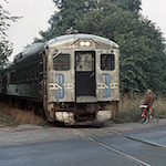
Driving north on NY rt. 9 towards Round Lake there are 2 RR overpass bridges. One says D&H on it and still looks active and the other one just before you enter Round Lake looks like a rail trail. What RR was that and where did that line go to?
 #1394759  by Noel Weaver
 
If this is what I think it is you went under the old D & H mainline that went through Round Lake
They built a new connection to the line north which bypassed Round Lake a good many years ago so this line has been gone for a long time. Round Lake is a really nice little village and is well worth a visit. It was once a Methodist Camp Meeting site that became a village maybe in the 1960's or so. It still has a wonderful old auditorium that dates back to the 1880's with a pipe organ that dates back to 1847 and still sounds good today. When I was still working in Selkirk and lived a reasonable distance away I volunteered here and although it was work I enjoyed it very much. The community room in the village building has the name plate from the old station building.
Noel Weaver
 #1394803  by pumpers
 
Indeed the bridge just before town is now the "Zim Smith" trail: https://en.wikipedia.org/wiki/Zim_Smith_Trail" onclick="window.open(this.href);return false;

The bridge a mile or so south of that is the current D&H connection between Mechanicville and the mainline, to connect both north and south (well, going south is NS now). Also used by Pan Am to connect to the CSX (ex NYC) water level line heading west (Rotterdam Jct I believe).
 #1394972  by B&M 1227
 
This is the original Rensselaer & Saratoga yes? Seems that when the D&H merged everything together the R&S was deemed the inferior route and parceled into branchlines and abandonments in favor of the other roadbeds. Slightly off topic but the D&H facebook group has pics of the R&S street running down 2nd(maybe?) Street in Waterford.
 #1396245  by Engineer Spike
 
The R&S is still an important part of the D&H. In the 1960s, as stated, D&H built a 1 mile connector, which we call the "million dollar wye". This saved maintaining about 9 miles of track. I have also heard that Round Lake wanted the railroad out of town.

The new connector runs from Crescent, on the Mechanicville Branch (now Freight Main), to the Ballston Branch (now part of the Canadian Main). The rail for the connector supposedly came from one of the main tracks through Saratoga, which was taken up. If Chief Troll sees this, maybe he can confirm or deny this.

The bike path starts at Coons Crossing, near the top end of Mechanicville Yard. It ends on Oak St. Ballston Spa. The parts in Ballston, and Malta are paved, but the Halfmoon section has compacted crusher run.
 #1396325  by B&M 1227
 
I've walked a little bit of the crushed stone path in Halfmoon... nice walk albeit not all that visually exciting. I know the R&S south of Waterford wound up becoming a branch into the 70s, maybe early 80s. Between Mechanicville and Waterford was it parallel routes similar to the B&M in eastern NY, or was that section of the R&S abandoned awhile ago? IIRC you can see parts of the R&S ROW to the east of 787 between Waterford and Green Island.

Jeffrey Plant photos of the R&S street running in Waterford
https://scontent.fbos1-1.fna.fbcdn.net/ ... e=581D0578" onclick="window.open(this.href);return false;
https://scontent.fbos1-1.fna.fbcdn.net/ ... e=5821D076" onclick="window.open(this.href);return false;
 #1396542  by pumpers
 
B&M 1227 wrote:. Between Mechanicville and Waterford was it parallel routes similar to the B&M in eastern NY, or was that section of the R&S abandoned awhile ago? IIRC you can see parts of the R&S ROW to the east of 787 between Waterford and Green Island.
B&M, I spent some time Googling around last night.
The original R&S went from Green Island (and perhaps over the bridge to Troy too?) up to Mechanicville, Round Lake, and Ballston Spa as earlier discussed .
It seems there was an Albany and Northern (completed in 1853), reorganized as the Albany, Vermont, & Canada, then as the Albany & Vermont, which was bought by the R&S in 1860. It went from Albany north (on what later became known as the Colonie main of D&H) through Waterford, meeting the R&S at what became Waterford function , paralleling a few miles, and then crossing the R&S and crossing the Hudson river just north of the Waterford/Halfmoon border . [From there it followed then Hudson north until it cut northeast and then followed the Hoosic River to Eagle Bridge. ] The purchase got R&S down into Albany, and R&S made an agreement with the Troy and Boston (later B&M) not to use it north of Waterford junction. North of there it was abandoned. The ROW along the Hoosic river up to Johnsonville later became the current main (now Pan Am) to Mechanicville. (There were 2 B&M lines along the Hoosic River, one of which was the A&V ROW, for many years which B&M noted above). You can see the abandoned line along the east side of the Hudson on this link if it works (choose Topo mode): http://mapper.acme.com/?ll=42.84848,-73 ... ville%20NY" onclick="window.open(this.href);return false;
Here is a good history link: https://books.google.com/books?id=2ttWU ... ad&f=false" onclick="window.open(this.href);return false;
In 1871 the D&H leased the R&S which presumably included this southern part of the A&V.
So to make the long story short, there never were 2 D&H lines north of Waterford Junction to Mechanicville. There were two for a few miles north of Waterford Jct. before the 1860 purchase of the Albany & Vermont, but that's it.
EDIT: Fixed a bunch of typos and added the date of the D&H takeover of the R&S
 #1396607  by B&M 1227
 
Ahh! So the Colonie Sub Waterford-Mechanicville is the original R&S. Despite working over the D&H, I never really looked into the previous ownership of it. The present day freight main from 468 (Mechanciville) to 480 (junction with Canadian sub north of Mohawk), was not the R&S though, so I suppose I'll have to research that lines history tonight...

On the subject of the Albany Northern, I've followed a bit of it's ROW south of Schaghticoke. In the winter the roadbed is actually very visible at Snyders (MP462 where the pan am main turns eastward away from the Hudson), where you see it disappearing southward, hugging the hillside on an embankment. Somewhere out there is a book with a picture of the AN's wood suspension bridge crossing of the Hudson at Waterford. It was my understanding that the AN was banking on the timely opening of Hoosac Tunnel, which didn't work out too well for them.
 #1396642  by pumpers
 
B&M 1227 wrote:Ahh! So the Colonie Sub Waterford-Mechanicville is the original R&S..
To be clear, assuming "Colonie Sub" means the present line from Albany (Kenwood?) up to Mechanicville, passing by Colonie shops site along Lincoln Ave, the south part (Albany to Waterford Jct) was the Albany Northern (later Albany & Vermont), not the R&S. The original R&S was the now-abandoned line to the east, from Green Bridge up to Waterford Jct. From Waterford Jct up to Mechanicville, that was the R&S.
Hard to believe the Albany Northern RoW is still visible, some 150 years after abandonment!
Let us know what you find out about the current line heading west from Mechanicville.
JS
PS: B&M, you are right - it was the "Albany Northern RR", not the "Albany & Northern RR"
 #1398240  by greenwichlirr
 
The multiple tracks that were outside the old Green Island shops were scrapped about ten years ago or so, and a lot of the rail ended up at The Battenkill RR. I helped with the work on a day or two.

I also was able to save one of the switchstands that day. It's amazing to think of how much of what was still left up until the last decade is now gone, between the scrapping, the big fire, and the bike trail.
 #1398289  by trainsinmaine
 
One of the piers of the Albany Northern trestle across the Hudson is still visible from the parking lot in back of the Subway and Pizza Hut at the corner of 123rd Street and Second Avenue (U.S. Route 4) in the Lansingburgh section of Troy.

I'd love to see the photo of that bridge. It's been gone since 1860. It is indeed possible to trace some of the roadbed once you get out of the city and head north.
 #1398297  by B&M 1227
 
I'm wondering if that pier is from something else? I was under the impression the AN crossed the Hudson immediately south of the intersection of Riley Rd and River Rd in Melrose.
 #1398355  by trainsinmaine
 
I'll check that out. I'm going by what a supposedly reliable online source has indicated. It sticks in my mind that somewhere I have seen a photo of its location with two piers visible, but it was quite some time ago and I can't remember where I saw it.
 #1398433  by trainsinmaine
 
Well, B&M1227 my friend --- on the basis of an up-to-date topo map that I just looked at, I'm very much inclined to say that you're right and I'm wrong. I don't know what that pier is to which I alluded. It would be interesting to drive to the spot you suggested to see whether any remnants of the easterly abutment can still be seen. I've driven down River Road a couple of times in years past and noticed the Albany Northern ROW (plainly evident in certain places). but I was never able to figure out where the river crossing was. I'll have to search it out more closely the next time I travel to that area.

It's fun to trace the old B&M main to Troy down through that neck of the woods, too. I traveled that line several times as a passenger when I was a little boy (indeed, almost right up to the time the service was discontinued). I have a vivid memory of passing by the Johnsonville depot in the evening in a snowstorm.
 #1398500  by pumpers
 
take a look at these 1866 maps:
http://www.historicmapworks.com/Map/US/ ... /New+York/" onclick="window.open(this.href);return false;

http://www.historicmapworks.com/Map/US/ ... /New+York/" onclick="window.open(this.href);return false;

I believe the Albany Vermont & Canada shown on the maps is the immediate successor to the Albany Northern. These maps suggest the more northern crossing by Riley Rd, at least at this date (which may reflect the condition a few years earlier)