BTW, I found some of the Maps on your first link a bit disturbing - the 1986 Long Island Freight Map seems to indicate a float operation to Staten Island [I guess it's just a really inaccurate map representation of Greenville in Jersey City, although it looks silly - the B&O float operation must have been gone by 1980 (and wouldn't be ConRail either)].
The 1990s Central Freight Branch map showing the sidings off the Central Branch is just plain wrong - I was often in that area in the 1980s even (and passed through on my commute every workday in the 1990s), and there were very few remaining sidings even then.[/quote]
Hi Sir Ray: I am currently on the hunt for R. Emery maps of that area. LI Ave and Commack Rd. Thanks for pinpointing the location. As far as the maps on this page:
http://www.trainsarefun.com/lirr/lirrmaps.htm...these area maps are provided by others, and as we all know maps by themselves are questionable at best until backed up with ETTs, photos, on the scene employee reports, etc.
Are these maps really "a bit disturbing" or just not proto correct? Agree, but the page is of what is available, etc.
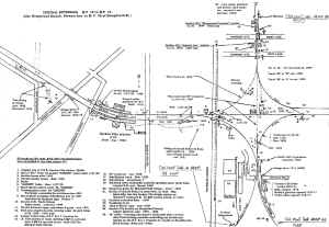
1. The NYA inaccurate map was/is a LIRR Freight Brochure 05/86 Archive: Paul Strubeck, thus your beef should be with the artist and marketing dept of NYA.
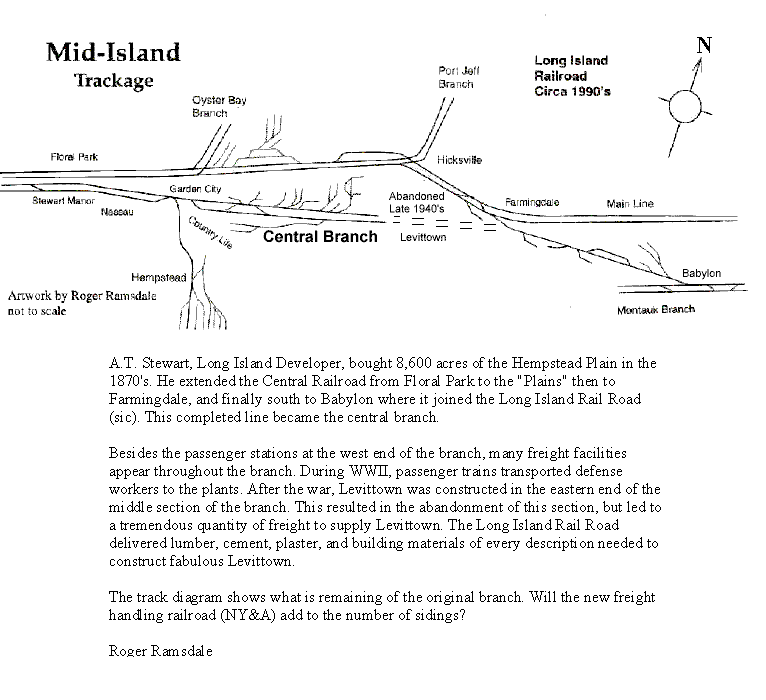
2. The 1990's Central Branch drawing and Article at "
http://www.trainsarefun.com/lirr/images/central.gif" is Roger Ramsdale's appearing in Cannonball or Semaphore. IMHO only: His intent was to provide an overview not a detailed tome, etc. Please contact him to further discuss his inaccuracies.
3. To go to the other end of the spectrum where I post data I believe to be known, factual, and accurate; here's an example:
http://www.trainsarefun.com/lirr/islip/islip.htm
4. Rather then nitpick a person's efforts: Perhaps provide better maps, links to your website(s) historical data, an update map to the "incorrect info" posted, etc.
Clearly a great map of the 2. The 1990's Central Branch drawing and Article would be of interest to all.
http://www.trainsarefun.com/lirr/mineola/mineola.htm part of the Central Branch.
Emery map 1959 Hempstead Branch to Garden City MP20 north/south Also, Central Extension (Branch) MP18-MP19 west/east
http://www.trainsarefun.com/lirr/mineol ... tead-4.jpg
5. Please post additional maps, info on this branch so as to correct: ..."I was often in that area in the 1980s even (and passed through on my commute every workday in the 1990s), and there were very few remaining sidings even then..."
Thanks for your constructive criticism and we await the corrections, more accurate data, and your insight to correct the posted errors on this page.
Regards,
Steve Lynch