• 3-Track Stations

  • Discussion related to DC area passenger rail services from Northern Virginia to Baltimore, MD. Includes Light Rail and Baltimore Subway.
Discussion related to DC area passenger rail services from Northern Virginia to Baltimore, MD. Includes Light Rail and Baltimore Subway.

Moderators: mtuandrew, therock, Robert Paniagua

  by redline43
 
Why were National Airport and West Falls Church stations built with 3 tracks while the rest of the stops in the system were built with 2? Were there any plans that would require 3 tracks rather than 2 that Metro planned but never took shape?

  by Gerry6309
 
A three track station can serve as a turnback without tying up the through tracks. The Airport would certainly rate such a facility under certain circumstances. Perhaps as designs evolved, such needs were dropped from the plans.

  by Robert Paniagua
 
And not to mention Reagan National Airport was also a terminal stop for the Blue Line from 7/1/77 till 1991 so that middle track was used for turning the Blue Line there until the Virginia Southwestern Extension opened thus decreasing the usage of the center track

  by redline43
 
Yes, the Blue Line once terminated at National Airport while the Yellow continued to Huntington, but if that was the only planned use of the 3rd track why didn't Metro's engineers just spring for a pocket track just beyond the station rather than an entire 3 track station complex? When Yellow Line trains terminated at Mt. Vernon Square, they used a pocket track instead of a 3 track station. When Blue Line trains terminated at Stadium-Armory, they used a pocket track instead of a 3 track station. When Green Line Commuter Shortcut trains terminated at Farragut North, they used a pocket track instead of a 3 track station. Were there any other contributing reasons that required 3 tracks instead of 2 (a shuttle perhaps?). What about West Falls Church?

  by Sand Box John
 
"redline43"
Why were National Airport and West Falls Church stations built with 3 tracks while the rest of the stops in the system were built with 2?


As Gerry6309 said they were built to serve the purpose of turning back train short of the final terminal (short turn trains). The station are simply stations with the turn back pocket track built in the middle of the island platform instead of beyond the platform. There are a total of 7 pocket track on the railroad. Grosvenor (north of platform), Farragut North (north of platform), Silver Spring (north of platform), National Airport (at platform) D&G junction (between Stadium-Armory and Benning Road Blue line, Minnesota Avenue Orange line), Mount Vernon Square (north of platform) and West Falls Church (at platform). The station that have pocket track located adjacent to station are always located beyond the outbound end of the platform. Early plans call for a pocket track at Naylor Road (east of platform) The southern Green line F Route is the only line that does not have a pocket track between the downtown transfer stations and the end of line terminal.

The reason why pocket tracks were built instead simple crossovers is because short turn trains can be turned within the pocket tracks with fouling main line tracks. It also allow the trains to be operated at headway as close a 90 seconds inbound of the pocket track.

In the case of National Airport, the lay out of the elevated made it simpler and I will assume cheaper to put the pocket track within the confines of the station platform. National Airport was the south end of the Blue line from day that line opened on 07-04-1977 to the day the Yellow line was extended to it's final terminal at Huntington on 12-17-1983. The tail track south of platform at that time extended to the end of the elevated on the west side or The George Washington Parkway. The tail tracks were used for storage and light maintenance during the period of time National Airport was the west terminal of the Blue line.

A similar situation exists at West Falls Church because of the location of the yard lead connecting the main line track to the Fall Church Yard. The yard lead and the outbound end of pocket track connects to the main line in the same interlocking on that end of the platform. The West Falls Church pocket track is unique because it is the only pocket track on the railroad that is 1200' (365.76m) long. All of the other pocket tracks are 600' (182.88m) long.

Were there any plans that would require 3 tracks rather than 2 that Metro planned but never took shape?

No.

Little FYI: The Silver line, N route Tyson, Dulles Loudoun County branch will have 2 pocket track on it. Wiehle Avenue (west of platform), Dulles Airport (west of platform adjacent to north end of Autopilot Drive). Original plans called for pocket tracks to also be located at Tysons West (Spring Hill Road) (west of platform) and Tysons East, (WestGate) (east of platform). The pocket track located at the east end of the Tysons East (WestGate) station would have been unique because it would have been the only station with a pocket track located beyond the inbound end of the platform.
Last edited by Sand Box John on Sat Aug 02, 2008 4:29 pm, edited 1 time in total.

  by redline43
 
Thank you Sand Box John!

The reason I asked is because I read somewhere (I can't remember where) that West Falls Church was 3 tracks so the Dulles line could terminate on the center track and operate like a shuttle. With the current plans it doesn't look like that will be the case, but I was wondering if that was actually a formal plan, and if anything similar was planned for the National Airport center track. However this doesn't sound like it was the case. Thanks again!

  by Sand Box John
 
"redline43"
Thank you Sand Box John!


You are welcome.

The reason I asked is because I read somewhere (I can't remember where) that West Falls Church was 3 tracks so the Dulles line could terminate on the center track and operate like a shuttle. With the current plans it doesn't look like that will be the case, but I was wondering if that was actually a formal plan, and if anything similar was planned for the National Airport center track. However this doesn't sound like it was the case. Thanks again!

Who ever wrote that didn't have a clue. I have read similar crazy ideas posted on USENET at misc.transport.urban-transit that have suggested using the Falls Church Yard leads to allow the terminating of some of the trains off the Tyson, Dulles, Loudoun N Route branch in the platform pocket track at West Falls Church station.

One of the alternative that suggested during the early stages of the alignment evaluation process (Alternative T7) was to put the junction west of the West Falls Church station and run the alignment into Tysons Corner along Leesburg Pike VA-7. That alternative was rejected because of the effect that alignment would have along Leesburg Pike between VA I-66 and the Capital Beltway, that alignment would not have served the area along Chain Bridge road north of Leesburg Pike and the cost of building the alignment in the Leesburg Pike easement.

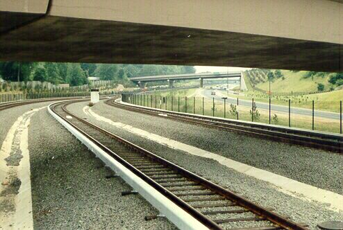
The original plan dating back to the 1960s was to build the junction east of the West Falls church station. Provision for the junction are in place. The column seen in this photograph between tracks K1 and K3 was put in to carry inbound track N1 from the Dulles branch over the west bound lanes of VA I-66 and the existing K route orange line tracks to the junction under the Haycock Road overpass. In this maps.live.com birds eye picture you can see where the third rail gaps and the tapering of the security fence is where the junction turnouts were planed to be located. I say were because present plans call for the junction to be located under the Great Falls Street overpass adjacent to the Great Falls Street traction power substation.

On pages 66-71 of Volume IV Chapter 3 Plan and Profile (54.4 MB PDF file) of the Dulles Corridor Metrorail Project Final Environmental Impact Statement and Section 4(f) Evaluation you see the present planed configuration of the junction with the existing K route Orange line.

  by WMATAGMOAGH
 
Who ever wrote that didn't have a clue. I have read similar crazy ideas posted on USENET at misc.transport.urban-transit that have suggested using the Falls Church Yard leads to allow the terminating of some of the trains off the Tyson, Dulles, Loudoun N Route branch in the platform pocket track at West Falls Church station.
It makes sense if you only look at the track map and don't realize how tight the curve on the yard lead is. It is the same radius as the loop track you and I rode when on the rodeo trains a few years ago, isn't it?

I've said before, I expect Dulles to be busier than Vienna after time, so Vienna would be short turned, if a line is short turned at all. That said, the advantage to the WFC layout is you could get Dulles trains on one side of the platform, and Vienna on the other, but the layout is also flexible enough that both tracks can serve both branches. All inbounds could just arrive on K1.

Of course, it seems the real logic behind the center track at WFC was to have a place for putins and dropouts to sit without fouling up the main line.

  by realtype
 
Sand Box John wrote:"redline43"
There are a total of 7 pocket track on the railroad. Grosvenor (north of platform), Farragut North (north of platform), Silver Spring (north of platform), National Airport (at platform) D&G junction (between Stadium-Armory and Benning Road Blue line, Minnesota Avenue Orange line), Mount Vernon Square (north of platform) and West Falls Church (at platform). The station that have pocket track located adjacent to station are always located beyond the outbound end of the platform. Early plans call for a pocket track at Naylor Road (east of platform) The southern Green line F Route is the only line that does not have a pocket track between the downtown transfer stations and the end of line terminal.


I'm pretty sure there is an underground pocket track at Ft. Totten station east of the platform. Yellow line midday trains currently use it to reverse direction. Or maybe its the same track used to connect the Red and Green Lines?

  by WMATAGMOAGH
 
Trains relay on Track E2, blocking the main line. That is part of the reason Yellow Line service doesn't go beyond MVS during rush hour.
realtype wrote:
Sand Box John wrote:"redline43"
There are a total of 7 pocket track on the railroad. Grosvenor (north of platform), Farragut North (north of platform), Silver Spring (north of platform), National Airport (at platform) D&G junction (between Stadium-Armory and Benning Road Blue line, Minnesota Avenue Orange line), Mount Vernon Square (north of platform) and West Falls Church (at platform). The station that have pocket track located adjacent to station are always located beyond the outbound end of the platform. Early plans call for a pocket track at Naylor Road (east of platform) The southern Green line F Route is the only line that does not have a pocket track between the downtown transfer stations and the end of line terminal.


I'm pretty sure there is an underground pocket track at Ft. Totten station east of the platform. Yellow line midday trains currently use it to reverse direction. Or maybe its the same track used to connect the Red and Green Lines?

  by Sand Box John
 
"WMATAGMOAGH"
It makes sense if you only look at the track map and don't realize how tight the curve on the yard lead is. It is the same radius as the loop track you and I rode when on the rodeo trains a few years ago, isn't it?


It is.

By the way the rodeo was held this past weekend (05-03-2008) at Branch Avenue Yard. Metro's annual Rail Rodeo rounding up on May 3 I was unable to attend. For future reference to all, for the last 4 years the Rail Rodeo has taken place on the first Saturday in May. Unlike Rail Rodeo held by other agencies WMATA's Rail Rodeo is open to the general public. Arrive early and you will get the chance to ride aboard trains operated in the yard.

I've said before, I expect Dulles to be busier than Vienna after time, so Vienna would be short turned, if a line is short turned at all. That said, the advantage to the WFC layout is you could get Dulles trains on one side of the platform, and Vienna on the other, but the layout is also flexible enough that both tracks can serve both branches. All inbounds could just arrive on K1.

Of course, it seems the real logic behind the center track at WFC was to have a place for putins and dropouts to sit without fouling up the main line.


The biggest problem with routing trains through the yard to the West Fall Church station is all of the track in the yard and connecting lead tracks are restricted to 15MPH. The tracks in the yards are not configured for ATO or ATP. The yard tower operator would be required to manually set all turnouts and signals to route trains through the yard.

"realtype"
I'm pretty sure there is an underground pocket track at Ft. Totten station east of the platform. Yellow line midday trains currently use it to reverse direction. Or maybe its the same track used to connect the Red and Green Lines?


No pocket track east of Fort Totten, just a double crossover and the turnout to the B route connector track.

Here is the track schematic of the existing system. Copies of this schematic can be found in offices adjacent to Operation Control Center.

Here is the track schematic of the system with the Tysons, Dulles, Loudoun county N Route branch added.

  by WMATAGMOAGH
 
If WMATA wanted to send trains to Dulles via the WFC yard, I'm sure they could reconfigure things so that ATC and ATP would work in the yard, and that the switches could be set by someone other than the yard tower operator.

  by Sand Box John
 
"WMATAGMOAGH"
If WMATA wanted to send trains to Dulles via the WFC yard, I'm sure they could reconfigure things so that ATC and ATP would work in the yard, and that the switches could be set by someone other than the yard tower operator.


I am sure they could. In my opinion it would be a worthless effort. The running time through all of the restricted speed track work between the N route yard lead junction and the West Fall Church station would be longer then just running the trains to the East Falls Church station. There also is the matter of funding the reconfiguration, it wont be put the budget for phase I of the Tysons, Dulles, Loudoun County project.