by R&DB
AWSmith wrote: ↑Tue Oct 04, 2022 7:03 pm This will be my first post here as I have been watching this thread in my excited anticipation of the FIT being opened up again. I had assumed its juncture with the southern secondary was a "wye" in both north and south directions but I see via Historical imagery that the south leg was actually a diamond that continued on to Manasquan . Any Idea what this El shaped building was at the diamond? A station? a control tower? https://www.historicaerials.com/locatio ... 99/1957/19Farmingdale Station. Dual use PRR and CNJ. My avatar (above right) is an earlier photo of the same station. If you look closely at Gmaps to see the property lines, the RR RoW is configured for a Wye. It was just never built.
Harry
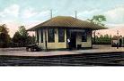
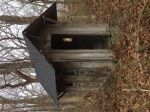
 The old Farmingdale RR Station