Railroad Forums 

  • North Broad/South Penn Concourses

  • Discussion relating to Southeastern Pennsylvania Transportation Authority (Philadelphia Metro Area). Official web site can be found here: www.septa.com. Also including discussion related to the PATCO Speedline rapid transit operated by Delaware River Port Authority. Official web site can be found here: http://www.ridepatco.org/.
Discussion relating to Southeastern Pennsylvania Transportation Authority (Philadelphia Metro Area). Official web site can be found here: www.septa.com. Also including discussion related to the PATCO Speedline rapid transit operated by Delaware River Port Authority. Official web site can be found here: http://www.ridepatco.org/.

Moderator: AlexC

 #1600333  by mcgrath618
 
Good morning all,
It was a long-standing dream of mine to be able to bump the old discussion thread from 2012 on the North Broad/South Penn concourses with new information, but unfortunately it has since been lost to time.
I am now much older, and an employee of a certain Authority that very graciously granted me access to these two concourses yesterday evening. It was a lifelong dream finally realized.
I am uploading some photos right now to Flickr, would be more than happy to share. In the meantime, I'd like to address some of the questions that people have had in the past, and any you may have in the present.

For those unaware, the North Broad Concourse refers to a disused pedestrian connection between the Municipal Services Building and Race-Vine Station. It was closed due to safety concerns, partially used as a fallout shelter, and was partially used as a police barrack until 2004. The South Penn Concourse refers to the old disused pedestrian connection between the former routing of the Subway-Surface lines at 15th and Walnut-Locust. It was closed when the trolleys were rerouted to their current path due to the El requiring underpinning running right through the concourse.

1) What condition are the two concourses in?
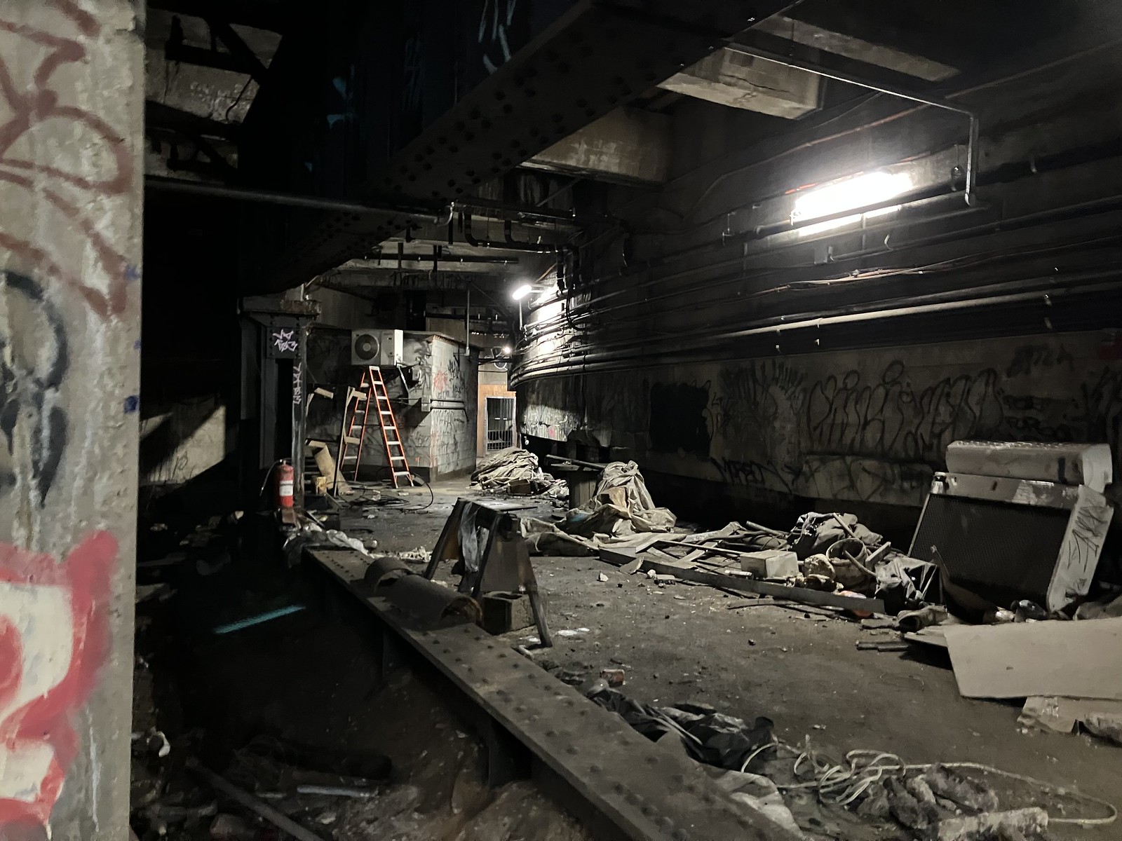
The North Broad Concourse has fared far better than the South Penn Concourse. They put Bakelite (or something similar) on the ceiling to waterproof it, which has held up quite well. The sections that don't have this have fared about as well as you could have hoped. The North Broad Concourse has also been cleaned a little, with SEPTA disposing of most of (but not all of) the stuff left behind by the PPA. The South Penn Concourse is easier to access but lesser known, so there had clearly been more... intrusion than the North Broad section. The girder underpinning City Hall is still intact (thank God!) and has held up well.

2) Can the Arch Street Subway be accessed via the North Broad Concourse?
No. This was a question I had always wondered myself and now finally have the answer to. I found no evidence of any such connection. All doors running east of Broad led to rooms with no other exits. I assume this confusion stems from the fact that part of this concourse was built to provision for a future loop of the Broad Street Line under the Merritt Taylor plan.

3) Is 15th Street Station still there?
Barely. The turnstiles are long gone, and very little evidence remains that there was ever a station. Most of what exists is just the trolley ROW.

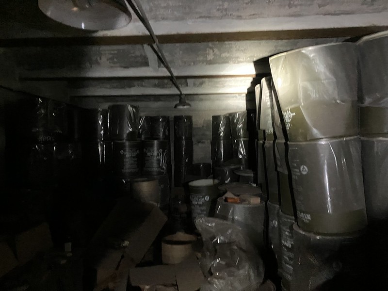
4) Is the North Broad Concourse still a fallout shelter?
Yes. The 10-gallon drums are still present, full of various survival items from the 1950s/60s. Plenty of laxatives.

5) Can I get in?
No. SEPTA has barricaded both concourses to prevent vagrant activity. Please do not attempt to get in, you will quickly be caught.

One question of my own that I pose to the group now is the following: off of one of the fallout shelter rooms, on the west side of Broad, there was a secondary room with a large hole above Track 1 of the Broad Street Line. Above it, the ceiling pattern (I believe I've heard the term "scalloping" to describe this PTC hallmark) abruptly stops. Was this at one point access from the street to lower equipment into the tunnels? It is very close to some very minor provisions for the aforementioned loop, but I don't think the two are related (more likely, the PTC realized they had some extra space, so they dropped a crane in and used it for that instead).
 #1600628  by scotty269
 
mcgrath618 wrote: Thu Jun 23, 2022 8:50 am I am now much older, and an employee of a certain Authority that very graciously granted me access to these two concourses yesterday evening. It was a lifelong dream finally realized.
Finally putting those YAC credentials to good use, eh? Eager to see the photo gallery once you get it uploaded.
 #1600630  by mcgrath618
 
scotty269 wrote: Sun Jun 26, 2022 8:11 pm
mcgrath618 wrote: Thu Jun 23, 2022 8:50 am I am now much older, and an employee of a certain Authority that very graciously granted me access to these two concourses yesterday evening. It was a lifelong dream finally realized.
Finally putting those YAC credentials to good use, eh? Eager to see the photo gallery once you get it uploaded.
Thank you for reminding me (plenty more photos in the Flickr album):

https://flic.kr/s/aHBqjzVWxp

Image

Image

Image
 #1601726  by dcipjr
 
Oh wow, I'm so jealous...I always found those old threads fascinating. Something about these forgotten places that are in plain view is so interesting.

Here are a few of the threads. There were others, but they seem to be gone.

mystery-broad-street-line-entrance-nort ... 79262.html

septa-quot-lost-quot-the-south-concours ... 27813.html

Here's a map of the concourse:

Image

I know where the North Broad concourse is (obviously) but where is South Penn?

Do you have any pictures of the former trolley station? Maybe it's one of the ones you posted, but I can't be sure.
 #1601734  by mcgrath618
 
dcipjr wrote: Thu Jul 07, 2022 11:54 am
I know where the North Broad concourse is (obviously) but where is South Penn?

Do you have any pictures of the former trolley station? Maybe it's one of the ones you posted, but I can't be sure.
South Penn wrapped around the west side of City Hall to allow movement from the old 15th street station to Walnut-Locust. It was made functionally useless by the rerouting of the trolleys.
My second image that I direct linked in the thread is taken closeby. If you duck right around that corner you can see where it was.
 #1601764  by dcipjr
 
South Penn wrapped around the west side of City Hall to allow movement from the old 15th street station to Walnut-Locust. It was made functionally useless by the rerouting of the trolleys.
I'm guessing, then, that it doesn't appear on the map I linked above? Since the rerouting would have been prior to that map's creation?
My second image that I direct linked in the thread is taken closeby. If you duck right around that corner you can see where it was.
Here, perhaps?

Image

It looks somewhat station-like. Any more pictures?

I have other questions too:

1. Does the North Broad Concourse really lead to the Inquirer building? Is the present concourse bisected by the Vine Street expressway cut? Is there still concourse north of Vine?

2. I notice on the concourse map that the concourse on the east side of City Hall curves gently around Penn Square, but the west side makes a 90 degree angle—is that missing curve where the South Penn concourse would have been?
 #1601774  by dcipjr
 
Another unanswered question from the old topic, which you may be able to shed some light on: the stairs leading down from the 15th St. MFL platform—where do they go?
 #1601792  by mcgrath618
 
dcipjr wrote: Thu Jul 07, 2022 3:48 pm
Here, perhaps

It looks somewhat station-like. Any more pictures?

I have other questions too:

1. Does the North Broad Concourse really lead to the Inquirer building? Is the present concourse bisected by the Vine Street expressway cut? Is there still concourse north of Vine?

2. I notice on the concourse map that the concourse on the east side of City Hall curves gently around Penn Square, but the west side makes a 90 degree angle—is that missing curve where the South Penn concourse would have been?
Yes! I had forgotten that I'd taken that one. Unfortunately, it was very hard to take any photos to begin with, so I'm sorry but I can't provide anymore. I need to go back there with a camera...

1) I found no evidence of this, but I think it would be interesting to investigate. I will report back later.

2) Good eye! Yes! that is precisely where it was.
 #1601793  by mcgrath618
 
dcipjr wrote: Thu Jul 07, 2022 4:42 pm Another unanswered question from the old topic, which you may be able to shed some light on: the stairs leading down from the 15th St. MFL platform—where do they go?
I will get back to you on this one as well. I have my suspicions but want to confirm them first.
 #1601836  by dcipjr
 
mcgrath618 wrote: Thu Jul 07, 2022 6:48 pm 2) Good eye! Yes! that is precisely where it was.
I thought so! It makes sense; your pictures of the area all show a curve, so that was presumably the old routing of the concourse.

If memory serves, a picture similar to that first picture that you posted (of the curving passage filled with stuff) was posted by another user here a long time ago, but it has been lost over the years.

Some maps of the concourse in the Philly library's digital collections bear this out.
I will get back to you on this one as well. I have my suspicions but want to confirm them first.
Thanks! Someone mentioned it years ago in the other thread, and I remember peeking at the stairwell myself, and have always wondered.
 #1601837  by dcipjr
 
For anyone else that's interested, this map in the Philadelphia Library system provides a great map of the old concourse.

Click the Pan and Zoom button on that page to zoom in on the map, and there's a ton of detail.

It looks like it used to wrap around the entirety of City Hall.

A "3D" map is also available. You can clearly see that the concourse wrapped around the north side of City Hall.

The closed street-level entrances to the BSL on the north side of City Hall presumably lead to the northern part of the loop.

Another, more recent map shows that at some point (probably in the 30s?) the passage to the north of City Hall was closed, and only the southern route remained available. This map more closely resembles the present-day layout, but there are still a fair amount of differences.

It also looks like there were hallways that lead to Broad Street Station, which are now closed off.

The present-day concourse is a lot more choppy than the original concourse. There must be miles of closed passageways down there.
 #1617977  by JimBoylan
 
dcipjr wrote: Fri Jul 08, 2022 8:51 amFor anyone else that's interested, this map in the Philadelphia Library system provides a great map of the old concourse.
Click the Pan and Zoom button on that page to zoom in on the map, and there's a ton of detail. It looks like it used to wrap around the entirety of City Hall.
A "3D" map is also available. You can clearly see that the concourse wrapped around the north side of City Hall.
While the map is dated Dec. '31, the El tracks under City Hall didn't open until May '36 and the Locust St. Subway, until Feb. '53. Cross section D, under the SouthWest corner of Juniper & Filbert Sts., didn't happen until the Center City Commuter Tunnel in the early 1980s, and it was built a short distance farther SouthWest of the intersection. The 3-D map is even earlier, Apr. 25, 1929.
Both maps seem to show the trolleys being rerouted via the old El loop around City Hall and the concourse around it installed in the "old local track". Part of the trolley track was moved over to the El trackway later in the 1970s and 1980s, but very little of the concourse wound up in the old trolley trackway, as it had already been built more than 40 years earlier.
The 3-D map also shows a new 15th St. Westbound trolley station under West Penn Square. Notice that the wall separating the track from the concourse is neatly removed, phantom views elsewhere show jagged remains of walls.
 #1617978  by JimBoylan
 
dcipjr wrote: Thu Jul 07, 2022 3:48 pm1. Does the North Broad Concourse really lead to the Inquirer building? Is the present concourse bisected by the Vine Street expressway cut? Is there still concourse north of Vine?
The North Broad Concourse shared space with the Race - Vine Station mezzanine, like at Walnut - Locust where the concourse extends to Spruce St. The North end was at stairs to Broad St. just North of the Vine St. sidewalks, by the Hotel Philadelphia and hugging the West wall of Roman Catholic High School. If those stairs were to be restored, you would have to go down to the station platforms to get under the new Vine St. Expwy. and back up to the remaining North Broad Concourse.
 #1617979  by JimBoylan
 
dcipjr wrote: Thu Jul 07, 2022 4:42 pmAnother unanswered question from the old topic, which you may be able to shed some light on: the stairs leading down from the 15th St. MFL platform—where do they go?
mcgrath618 wrote: Thu Jul 07, 2022 6:50 pmI will get back to you on this one as well. I have my suspicions but want to confirm them first.
As the Free Library maps show, there is an underpass between the El platforms that used to continue to both trolley platforms. You can still look down them. I don't know if new connections were made to either of the new trolley stations.
 #1617982  by JimBoylan
 
South Penn wrapped around the west side of City Hall to allow movement from the old 15th street station to Walnut-Locust. It was made functionally useless by the rerouting of the trolleys.
My second image that I direct linked in the thread is taken closeby. If you duck right around that corner you can see where it was.
dcipjr wrote: Thu Jul 07, 2022 3:48 pmI'm guessing, then, that it doesn't appear on the map I linked above? Since the rerouting would have been prior to that map's creation?
Here, perhaps? Image It looks somewhat station-like. Any more pictures?
Those 2 photos with the never used supports for trolley boards in the roof and the sawhorse in the center are more likely the old El trackway under the NorthWest corner of Juniper & Ludlow Sts., the SouthEast corner of City Hall.