Totally cool photos! The re-aligned road (the houses are gone I see too) is called East River Road on Google Maps now? I don't know if its original name was Rochester Road or if it was renamed or just a typo. I'm too much of a outside-my-immediate-area novice cos I've been to the museums up that road before (but got to it from the north) and on 5&20 on different occasions and I just realized it's the same rail line and how close they are.
[And I see the 5 & 20 split to the west getting into Caledonia and I'm reminded how a black & white U-turned in behind me as I whizzed by at 60 when the speed limit had changed to 30. Tied the bow on that Finger Lakes Holiday ..]
Railroad Forums
Avon before and after
- Pertaining to all railroading subjects, past and present, in New York State.
Moderator: Otto Vondrak
Avatar: CSX eastbound on Lockport Sub approaching Lyric Ave 02.20.17
I figured someone would pick up on that eventually …
It's Rochester St., Rochester Rd., County Road 26 or East River Road depending on what map you look at and from what era. I know it as Rochester Road, so that's what I went with.
It's Rochester St., Rochester Rd., County Road 26 or East River Road depending on what map you look at and from what era. I know it as Rochester Road, so that's what I went with.

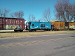
If you go north up that road a bit one of the industries has a green ex-Santa Fe caboose on a panel of track there.
When not in a hurry to come back from Buffalo I go this way, you have to jog either south or north to cross the river in what is otherwise more or less a straight line of back roads and I started going this way.
When not in a hurry to come back from Buffalo I go this way, you have to jog either south or north to cross the river in what is otherwise more or less a straight line of back roads and I started going this way.

I like the comparison! It's a bit hard to tell because of the difference in field-of-view between your camera and Street View, but I did pick up on the shape of that house matching in both images.
As for Rochester St, "Realigned" may be a bit misleading. I don't doubt that the center of the street is different than before but in looking at Historic Aerials it appears that they narrowed the road/took away the on-street parking and shifted the lanes as far west as they could, allowing for a sidewalk and "green space" between the road and the houses, where before the road appears to run right up to the sidewalk.
It's also interesting to note that the "lot" you show full of cars is as large as it actually is when looking from overhead. Holy moly, they packed a lot of cars into that space too! (https://www.historicaerials.com/locatio ... 72/2015/19 )
It looks like the Feed Mill is still there too. That is where that boxcar is parked.
Watch the train1 wrote:It looks like the Feed Mill is still there too. That is where that boxcar is parked.The "Feed Mill" was actually just a warehouse for the King Cole Bean Company (still standing) which was located track-side on the south side of West Main Street across from the Avon Depot.