Railroad Forums
Northern Electric
- Pertaining to all railroading subjects, past and present, in Pennsylvania
Moderator: bwparker1
I dont know if you have this link or not but theres a section about the NE on this page:
[url]http://lackawannatrail.railfan.net/[/url]
About the tunnel, was it split into two lines before the tunnel? I followed the line from near my house (about 3 miles south of the Nicholson viaduct) to a place where it crosses the road 1/2 mile west of the old tunnels, I then lost the ROW where it was dug up recently, it was actually going east in this spot. I just cant figure out where it would've went from there.
Yes. There is a book on it, self titled. Check Steamtown or other Scranton area hobby shops. Ebay may also be a location. And surely check out the local libraries.
No. It did not use the DL&W tunnels but rather climbed over the hill on a higher level about a half to one mile south of Route 11.
No. It did not use the DL&W tunnels but rather climbed over the hill on a higher level about a half to one mile south of Route 11.
[quote]No. It did not use the DL&W tunnels but rather climbed over the hill on a higher level about a half to one mile south of Route 11.[/quote]
Ah that explains it, I thought I stumbled onto an old road and started following that but it turns out it was the NE ROW the whole time.
Now, between the tunnel and the carbarn, I'm guessing the NE pretty much paralelled the DL&W until it broke off to go over the hill? I've been wanting to walk this stretch of it for a while but I'm not exactly sure where its at...
The "break off", as you called it, is actually gradual as RT 11 goes north (my bad above, the tunnels and rows are west of RT11, not south). Near Hop Bottom it finally goes on up the hill and towards Montrose. But the book has maps that explain and show better than I do.
I have had a huge interest in the NE for the past 20 years, and spent a good amount of time in the early 1990's tracing the line.
To answer some of the questions here...
... west of the carbarn, the NE went into the hills, and while it paralleled the DL&W, it was a bit more of a roller coaster. The grade is pretty obvious.
... it did not use the DL&W tunnels
When I last "chased' the line, it was of course easy to find the route on the Scranton end in the street. Up the gap, you can still make out the little quarry and the grade plays tag with the highway in bits and pieces. From Clark's out to Dalton the line is pretty easy to follow. Don't lose it when you get to the high bridge site.
Dalton station was still there last I looked. Past the carbarn, the line went hill and ale as mentioned. I believe the Factoryville depot is still standing, much modified, and the grade there is EZ to trace, as it is all the way out to Nicholson. In Nicholson, one depot remains,a nd I think the DL&W fireght hous eis still there, which the NE served.
West of Nicholson the grade is apparent. I have never been to Montrose, so cannot comment.
JH
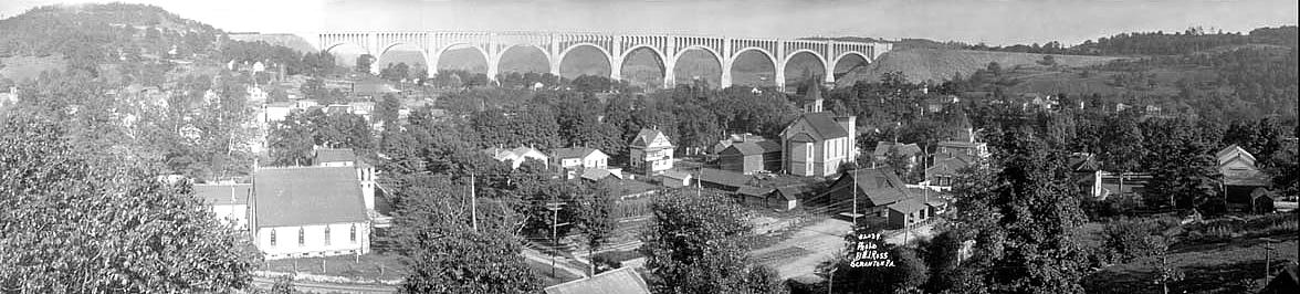
That is quite a revelation about the tunnels. Misinformation is always a burden when it comes to railfanning. Here I was under the impression they used the tunnel all this time. Having read it somewhere. Also, heading north towards Nicholson there are abutments in the river where a DLW spur? or mainline Northern Electric? veered and went to the west side of town. In certain photographs, that is where the Northern Electric was. Any ideas? Facts are ever so important in rialfanning. I just need concrete evidence, visual evidence would be best but it appears there are no known photos of the old bores when they were in operation. Check this picture: http://www.northeast.railfan.net/images/nicholson3.jpg
I believe the Northern Electric is in the foreground, on the west side of town. Any comments?
-Brian
http://www.trainworks.net/
I believe the Northern Electric is in the foreground, on the west side of town. Any comments?
-Brian
http://www.trainworks.net/
The bridge abutments are where the NE crossed. I've followed it from the tunnels to the creek a few times, but havent got a chance yet to go further north.
Is this the bridge (or rather what remains of it) that you mean? This is where the Northern Electric crossed Martin's Creek in Nicholson. I approached it from the north. (Click these images to see larger views.)

View of bridge abutments and supports from the north

The north abutment shows 1911 as the date of construction

Looking south, toward the creek
Zhanna

View of bridge abutments and supports from the north

The north abutment shows 1911 as the date of construction

Looking south, toward the creek
Zhanna
Last edited by Zhanna on Mon Feb 12, 2007 6:56 pm, edited 1 time in total.
Remember the DL&W mainline from Clark Summit to the tunnels was way different than today. Route 6 (&11) in effect was the right of way. At Dalton there were abutments where the trolley crossed the highway (railroad); but I haven't been along Rt 11 in a long time so I can't say the abutments are still there. Factoryville Station was a bar right there on the highway until in burned down in the 80's. The trolley line, I think, went on the west side of Factoryville.
I know that one of the abutments from the N. E. trestle that crossed the DL&W tracks still remains. It's on the west side of Routes 6&11 just north of Dalton. (Probably around N 41° 33.022' W075° 45.008' for the GPS-enabled. I'm planning to get better coordinates soon.)
Does anyone know about the abutment on the other side? Where was it, and is it still standing?
Zhanna
Does anyone know about the abutment on the other side? Where was it, and is it still standing?
Zhanna
Yes, that was the N.E. ROW.
I've used a yellow circle to indicate the location of the N.E. bridge on this map (again click for a larger view):

You can see the DL&W off to the east at that point.
The "Northern Electric Trolley" book by Norm Brauer includes a nice photo of the N. E. bridge in Nicholson when the bridge deck was still in place. I can scan it, but not until the weekend.
Zhanna
Last edited by Zhanna on Mon Feb 12, 2007 6:57 pm, edited 1 time in total.