Railroad Forums 

  • Lake Iliff

  • Discussion of the L&HR and its predecessor the Warwick Valley Railroad for the period 1860-1976 at its inclusion with ConRail
Discussion of the L&HR and its predecessor the Warwick Valley Railroad for the period 1860-1976 at its inclusion with ConRail

Moderator: David

 #241868  by purplezep
 
Ken, always enjoy your pictures.I was right near there this Sunday about 5pm, near Lake Aeroflex. Found a mile marker I missed in the fall because of heavy brush. Unfortunately, I haven't figured out yet how to post pictures!
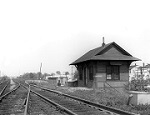
Did you realize you were right at Camp Nordland, a German/American Bund camp that was shut down by the government around the time of WW II? The L&HR delivered Germans via the Sussex Railroad from East Jersey,Newark, and NY City right near where you took the picture of the electrical relay box at Lake Iliff. The building is now part of Hillside Park.
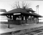
Lifecare Mews is a retirement community being built by the same company who bought the L&HR and Lackawanna Cutoff back in the 1980's. It's back on schedule to be built after working out utility problems. I'm familiar with the owner, and I've got some pics of the ROW from inside. There was a mile marker back there but looks like it got cleared out years ago. The Mulford station was pretty much where you took the picture of the small structure near the LifeCare Mews sign. Haven't been able to track down a picture of that station yet. My records show abandonement in 1933. Thanks for your offer to help with the preservation of structures on the ROW. As soon as I hear anything I'll let you know.
[/url]

 #241990  by NJ Vike
 
Hello Purplezep.

Thanks for the comments. I was there the same time you were as that's when I started hiking. You were approximately 2 miles away, if that.

Yes, I knew all about Camp Norland but only after reading about it in the Crist and Krause (SP?) book on the L&HR.

It's nice that Conrail left lots of ties signals and mileposts for us explorers and train fans to see although I'm sure that's not what they had in mind :-)

How long has it been since Lifecare Mews started this project? I've seen this place like this for about 10 years now.

I've got several other hiking trips planned to finish off the L&HR. One will start across from Limecrest to Lifecare Mews.

Some people believe that that small house by there was a RR station. I informed them that wasn't true as the ooks I have on the L&HR said that station burned down in the 1930s like you mentioned. I can't find any pictures of it nor do I know the exact location but I would surmise that it is probably near the entrance to the Lifecare Mews area.

There's a place where you can post your pictures to but I can't see to remember the place. Your Internet Provider should provide you with some space.

Let me know if you need assistance.

 #242220  by purplezep
 
Not sure of the exact start date of Lifecare Mews. I'll have to talk to my contact to find out. The station was right where that little house is, but that's definitely not the station. I have the maps from 1918 and it shows the station as being right there. There was a fiery accident in Mulford of the only Doodlebug car the L&HR owned in the 1930's, so that may have been the demise of the station.
I covered the ROW from Lake Iliff to Lifecare last fall, as well as Limecrest. There are some signal towers, ties, a mile marker, and a whistle post. Some of the ROW is extremely dense with pickers and brush, very difficult to navigate, but exciting nonetheless. I've pretty much covered and documented all the abandoned ROW, as well as most of the active track in NJ. It's cool to get different pictures during different seasons.
The most amazing thing is Andover junction-quite the hub of activity but now densely overgrown , as if nothing ever ran through there. You can still see the grade where the L&HR branched off the main to head towards Stanhope on the Sussex RR.
Good hunting! If you need help finding anything particular, let me know.

 #242339  by NJ Vike
 
I've covered much of NJ too but I'm really getting it done by foot :-)

I have explored the Sussex Branch and the L&HR at Andover Jct. and took the Sussex Branch just to where you go under the Cut-off.

Anyway, it looks like continuing towards Andover Jct. that there's lots of vegitation in the way.

The one place I would like to see is "G" Tower. Any ideas as to how to get there?

Thanks

 #242478  by purplezep
 
I was there last fall, it's off of Foul Rift Road near Belvidere. The foundation is still there yet, as well as some L&HR inactive track. You'll see some telegraph poles on the side of Foul Rift Road, then there's a few openings in the brush where you can either walk or take a mountain bike while heading back towards Belvidere. I believe the town name is also Foul Rift, but if you run a mapquest for Belvidere it will pull up Foul Rift Road. You'll be right near the Martins Creek Power Plant which is still served coal by the Bel-Del division of the PRR. I saw a 50 hopper train there in the winter and talked to the conductor. If you keep heading towards Belvidere, you will encounter a few cars left behind on inactive track, and eventually run into the Mansfield Street Station, which Amerigas now owns. You'll also see where the L&HR was double tracked, both tracks exist yet but are inactive

 #242493  by NJ Vike
 
purplezep wrote:I was there last fall, it's off of Foul Rift Road near Belvidere. The foundation is still there yet, as well as some L&HR inactive track. You'll see some telegraph poles on the side of Foul Rift Road, then there's a few openings in the brush where you can either walk or take a mountain bike while heading back towards Belvidere. I believe the town name is also Foul Rift, but if you run a mapquest for Belvidere it will pull up Foul Rift Road. You'll be right near the Martins Creek Power Plant which is still served coal by the Bel-Del division of the PRR. I saw a 50 hopper train there in the winter and talked to the conductor. If you keep heading towards Belvidere, you will encounter a few cars left behind on inactive track, and eventually run into the Mansfield Street Station, which Amerigas now owns. You'll also see where the L&HR was double tracked, both tracks exist yet but are inactive
Thanks for the info. I need to get there. This past winter, I was in the Brainards area and took some pictures there. There are a few concrete structures near the track. What they were I have no idea.

The tracks splits here and there's a bridge that goes over to PA. Is this track still active? How about going over the bridge?

 #242547  by purplezep
 
Track is still active over the trestle, wouldn't want to get caught there when a train is coming! I think it runs 1X/month. The bridge I'm thinking of runs over the Delaware to the power plant to deliver coal. Brainards did have a freight stop, that may have been remains of what you saw. The train I saw in the winter stopped right near the switchoff to transfer the cars from the main (Bel-Del) to the trestle to Martin's Creek.
Still haven't figured out how to attach pictures to the replies!

 #242666  by David
 
Ken--Mike and I checked out the G Tower foundation last summer. That was my third visit. Park at the old Mansfield Station and walk the L&HR line under a road bridge that you might have crossed over before you parked (Mansfield Ave). It is a little less then a mile of track to walk . It comes close to the tower foundation by the Bel-Del. As you walk the L&HR line, be on the look out for the 72 mile marker. It was the last milage marker on the old L&HR. Mike and I have a picture of it. Not a bad walk----

 #242681  by GOLDEN-ARM
 
Anyone got pix of those "left behind" cars? Where are they, and what reporting marks, if any? Thanks, :-D

 #242717  by NJ Vike
 
purplezep wrote:Track is still active over the trestle, wouldn't want to get caught there when a train is coming! I think it runs 1X/month. The bridge I'm thinking of runs over the Delaware to the power plant to deliver coal. Brainards did have a freight stop, that may have been remains of what you saw. The train I saw in the winter stopped right near the switchoff to transfer the cars from the main (Bel-Del) to the trestle to Martin's Creek.
Still haven't figured out how to attach pictures to the replies!
Contact me using this forum's e-mail option and I'll help you with uploading your pictures.

Thanks for the info too.

 #242718  by NJ Vike
 
David wrote:Ken--Mike and I checked out the G Tower foundation last summer. That was my third visit. Park at the old Mansfield Station and walk the L&HR line under a road bridge that you might have crossed over before you parked (Mansfield Ave). It is a little less then a mile of track to walk . It comes close to the tower foundation by the Bel-Del. As you walk the L&HR line, be on the look out for the 72 mile marker. It was the last milage marker on the old L&HR. Mike and I have a picture of it. Not a bad walk----
David,

Thanks. Let me know when you head out to NJ.

 #242719  by NJ Vike
 
GOLDEN-ARM wrote:Anyone got pix of those "left behind" cars? Where are they, and what reporting marks, if any? Thanks, :-D
Are you referring to those two Conrail cars left in Belvidere?

I do have shot of those if you're interested.

I can't believe they got left there :(

 #242827  by David
 
The cars are two gondolas in Conrail paint. Mike checked them out and found out that they are offically labled as "missing" or "lost". They are still filled with ties and junk from the ROW.

 #242961  by NJ Vike
 
David wrote:The cars are two gondolas in Conrail paint. Mike checked them out and found out that they are offically labled as "missing" or "lost". They are still filled with ties and junk from the ROW.
It's still kind of funny how they left them behind. I can hear someone in accounting scratching their heads back then.