Railroad Forums 

  • Jersey shore train stations

  • Pertaining to all railroading subjects, past and present, in New Jersey
Pertaining to all railroading subjects, past and present, in New Jersey

Moderator: David

 #1254352  by GSC
 
WhitingTrackPlan.jpg
This is about the best I can do. Note how the Tuckerton runs off to the lower right, the Pennsy to the left and right, and the CNJ to the top and bottom. Dotted lines show the original alignment.
 #1254353  by GSC
 
RRsta-whiting.jpg
Whitings Station, looking eastward.
 #1255438  by Splatz
 
GSC. Thank you. Better than what i have. I will run that book down and wait for a tax map lead here. Which Btw doesn't match waiting for a train at the Whiting Station on which I like to think was a warm sunny day in the spring when that photo was taken. Oddly the township I guess keeps the grass at the exact former site carefully manicured during the summer.
 #1257377  by GSC
 
TOMSTV wrote:http://s895.photobucket.com/user/TOMSTV ... 4.png.html?
Nice better view of the track plan than I got from the Brinckmann's Tuckerton RR book. Similar, and more detailed.

I don't know if any more new Tuckerton books exist. I bought mine directly from John Brinckmann, and he even signed it. His older style of writing is fascinating - something fun and flowery from around 1900 or so. Entertaining in itself.
 #1257378  by GSC
 
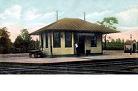
Splatz wrote:GSC. Thank you. Better than what i have. I will run that book down and wait for a tax map lead here. Which Btw doesn't match waiting for a train at the Whiting Station on which I like to think was a warm sunny day in the spring when that photo was taken. Oddly the township I guess keeps the grass at the exact former site carefully manicured during the summer.
That would be a most rewarding experience. Everything I have read about the era says that the junction was a bottleneck with heavy rail traffic. Pennsy surveyed several routes, mostly from around Medford to Manahawkin to bypass the congested three-way junction.

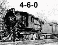
Wouldn't you just love to sit on that platform, cold glass of lemonade at the ready, and watch all of this "congestion"?
 #1257527  by R&DB
 
It would be kinda hard to turn an engine on that turntable today what with Station Road on top of it!
 #1257567  by GSC
 
No problem, the New Tuckerton RR runs push-pull.
 #1266541  by Splatz
 
img011.jpeg
Twilight Lake was once crossed by trestle as seen here in a period postcard. The captioner has the train headed "south" toward the Bay Head station, though looking at the photo it seems its northbound. The entire segment from Seaside Park to Bay Head junction suffered often from the intrusion of water not so much from nor'easters but the aftermath which when as it does today the wind pushes the Barnegat Bay ashore. The reconstruction of Rt.35 south may yield some ancient ROW ballast but I doubt it. Only the original straight line they surveyed in the late 1870s, with construction complete with resident railcars for the track workers occurred in 1883 evidence that anything like a steam engine ran on the barrier island with great regularity. I am guessing the line never even saw a diesel.